|
|
|
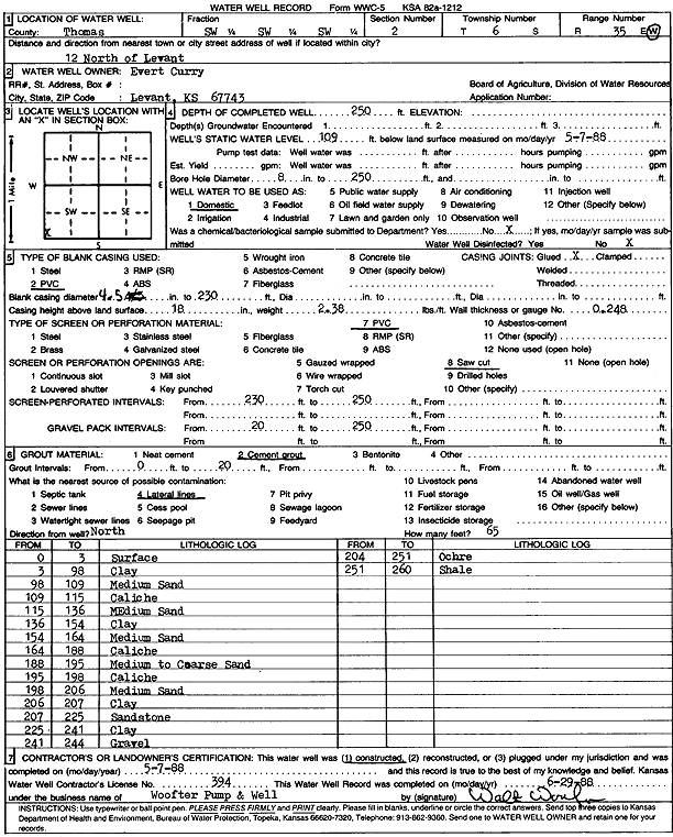
Specific Water Well Detail |
|
|
| Location Info | |||
| Owner: Curry, Evert | Status: Constructed | ||
| Location: T6S, R35W, Sec. 2, SW SW SW | County: Thomas | ||
| Directions: from Levant: 12 mi N | |||
| Latitude: 39.5556777 | Longitude: -101.2013888 | Datum NAD 27 | |
| Latitude: 39.5556784 | Longitude: -101.2018257 | Datum NAD 83 | |
| Longitude and latitude calculated by Survey from township-range-section-quarter calls. Only good to within the quarter call accuracy. | |||
| View well on interactive map | |||
| General Info | ||
| Well Depth: 250 ft. | Elevation: ft. | |
| Static Water Level: 109 ft. | Est. Yield: gpm. | |
| Comp. Date: 07-May-1988 | Well Use: Domestic | |
| DWR Applic. #: | Other ID: | |
| Driller Info | ||
| Driller: Walter Woofter Pump & Well | License #: 394 | |
| Scanned Form | View scan |
|
Chemical Sample Submitted?: No
Water Well disinfected?: | ||
| Ground water encountered: 0 ft. , 0 ft. , 0 ft. | ||
| Pump test data: Well water was 0 ft after 0 hours pumping 0 gpm | ||
| Casing Info | ||
| Casing Type: PVC
Casing Joints: |
Diam: 4 in. to 230 ft
Diam: 0 in. to 0 ft Diam: 0 in. to 0 ft | |
| Casing height above land surface: in
Casing Weight: lbs/ft Wall thickness or gauge no.: | ||
| Screen and Perforation Info | ||
| Screen Type: PVC | Screen Openings: Saw cut | |
| Screen-perforated intervals | From: 230 ft to 250 ft
From: 0 ft to 0 ft From: 0 ft to 0 ft | |
| Gravel pack intervals | From: ft to ft | |
| Grout Info | ||
| Grout used: Cement grout | From: 0 to 20 ft
From: 0 to 0 ft From: 0 to 0 ft | |
| Source of Possible Contamination | ||
| Source: Lateral lines | ||
| Direction from well: | Distance: 0 ft | |
| Lithologic Log
(Log data entered by KGS.) | ||
| From: 0 ft. to 3 ft. | surface | |
| From: 3 ft. to 98 ft. | clay | |
| From: 98 ft. to 109 ft. | medium sand | |
| From: 109 ft. to 115 ft. | caliche | |
| From: 115 ft. to 136 ft. | medium sand | |
| From: 136 ft. to 154 ft. | clay | |
| From: 154 ft. to 164 ft. | medium sand | |
| From: 164 ft. to 188 ft. | caliche | |
| From: 188 ft. to 195 ft. | medium to coarse sand | |
| From: 195 ft. to 198 ft. | caliche | |
| From: 198 ft. to 206 ft. | medium sand | |
| From: 206 ft. to 207 ft. | clay | |
| From: 207 ft. to 225 ft. | sandstone | |
| From: 225 ft. to 241 ft. | clay | |
| From: 241 ft. to 244 ft. | gravel | |
| From: 244 ft. to 251 ft. | ochre | |
| From: 251 ft. to 260 ft. | shale | |