|
|
|
Specific Water Well Detail |
|
|
| Location Info | |||
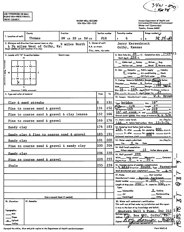
| Owner: Kersenbrock, Jerry | Status: Constructed | ||
| Location: T6S, R34W, Sec. 18, SW SE SW | County: Thomas | ||
| Directions: from Colby: 9 mi N and 5.5 mi W | |||
| Latitude: 39.5265578 | Longitude: -101.1597029 | Datum NAD 27 | |
| Latitude: 39.5265592 | Longitude: -101.1601389 | Datum NAD 83 | |
| Longitude and latitude calculated by Survey from township-range-section-quarter calls. Only good to within the quarter call accuracy. | |||
| View well on interactive map | |||
| General Info | ||
| Well Depth: 259 ft. | Elevation: ft. | |
| Static Water Level: 146 ft. | Est. Yield: 800 gpm. | |
| Comp. Date: 24-Jul-1975 | Well Use: Irrigation | |
| DWR Applic. #: | Other ID: | |
| Links | |
| View info from Wizard Water Level Data base... | |
| View info from WIMAS Water Right Data base... | |
| Driller Info | ||
| Driller: Western Well & Pump, Inc. | License #: 245 | |
| Scanned Form | View scan |
|
Chemical Sample Submitted?: No
Water Well disinfected?: | ||
| Ground water encountered: 0 ft. , 0 ft. , 0 ft. | ||
| Pump test data: Well water was 0 ft after 0 hours pumping 0 gpm | ||
| Casing Info | ||
| Casing Type:
Casing Joints: |
Diam: 0 in. to 0 ft
Diam: 0 in. to 0 ft Diam: 0 in. to 0 ft | |
| Casing height above land surface: in
Casing Weight: lbs/ft Wall thickness or gauge no.: | ||
| Screen and Perforation Info | ||
| Screen Type: | Screen Openings: | |
| Screen-perforated intervals | From: 169 ft to 249 ft
From: 249 ft to 259 ft From: 0 ft to 0 ft | |
| Gravel pack intervals | From: ft to ft | |
| Grout Info | ||
| Grout used: | From: 0 to 0 ft
From: 0 to 0 ft From: 0 to 0 ft | |
| Source of Possible Contamination | ||
| Source: | ||
| Direction from well: | Distance: 0 ft | |
| Lithologic Log
(Log data entered by KGS.) | ||
| From: 0 ft. to 131 ft. | clay and sand streaks | |
| From: 131 ft. to 152 ft. | fine to coarse sand and gravel | |
| From: 152 ft. to 166 ft. | fine to coarse sand and gravel and clay lenses | |
| From: 166 ft. to 176 ft. | fine to coarse sand and gravel | |
| From: 176 ft. to 183 ft. | sandy clay | |
| From: 183 ft. to 191 ft. | sandy clay and fine to coarse sand and gravel | |
| From: 191 ft. to 200 ft. | sandy clay | |
| From: 200 ft. to 206 ft. | fine to coarse sand and gravel and sandy clay | |
| From: 206 ft. to 220 ft. | sandy clay | |
| From: 220 ft. to 255 ft. | fine to coarse sand and gravel | |
| From: 255 ft. to 259 ft. | shale | |