|
|
|
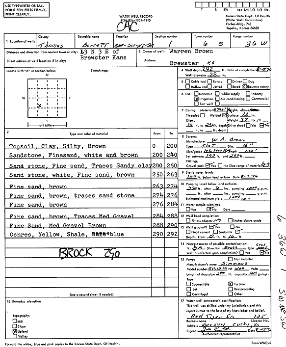
Specific Water Well Detail |
|
|
| Location Info | |||
| Owner: Brown, Warren | Status: Constructed | ||
| Location: T6S, R36W, Sec. 1, SW NE SW | County: Thomas | ||
| Directions: from Brewster: 13 mi N, 3 mi E | |||
| Latitude: 39.5591176 | Longitude: -101.2898994 | Datum NAD 27 | |
| Latitude: 39.5591174 | Longitude: -101.2903382 | Datum NAD 83 | |
| Longitude and latitude calculated by Survey from township-range-section-quarter calls. Only good to within the quarter call accuracy. | |||
| View well on interactive map | |||
| General Info | ||
| Well Depth: 292 ft. | Elevation: ft. | |
| Static Water Level: 150 ft. | Est. Yield: 1000 gpm. | |
| Comp. Date: 25-Aug-1976 | Well Use: Irrigation | |
| DWR Applic. #: | Other ID: | |
| Links | |
| View info from Wizard Water Level Data base... | |
| View info from WIMAS Water Right Data base... | |
| Driller Info | ||
| Driller: Duane Hauser, Red Tiger lrr. Drlg & Supply | License #: 125 | |
| Scanned Form | View scan |
|
Chemical Sample Submitted?: No
Water Well disinfected?: | ||
| Ground water encountered: 0 ft. , 0 ft. , 0 ft. | ||
| Pump test data: Well water was 0 ft after 0 hours pumping 0 gpm | ||
| Casing Info | ||
| Casing Type: Steel
Casing Joints: |
Diam: 16 in. to 192 ft | |
| Casing height above land surface: in
Casing Weight: lbs/ft Wall thickness or gauge no.: | ||
| Screen and Perforation Info | ||
| Screen Type: Steel | Screen Openings: | |
| Screen-perforated intervals | From: 192 ft to 292 ft | |
| Gravel pack intervals | From: ft to ft | |
| Grout Info | ||
| Grout used: | From: 0 to 0 ft
From: 0 to 0 ft From: 0 to 0 ft | |
| Source of Possible Contamination | ||
| Source: | ||
| Direction from well: | Distance: 0 ft | |
| Lithologic Log
(Log data entered by KGS.) | ||
| From: 9 ft. to 200 ft. | top soil, clay, silty, brown | |
| From: 200 ft. to 240 ft. | sandstone, fine sand, white and brown | |
| From: 240 ft. to 250 ft. | sandstone, fine sand, traces sandy clay | |
| From: 250 ft. to 263 ft. | sandstone, white, fine sand, brown | |
| From: 263 ft. to 274 ft. | fine sand, brown | |
| From: 274 ft. to 276 ft. | fine sand, brown, traces sandstone | |
| From: 276 ft. to 284 ft. | fine sand, brown | |
| From: 284 ft. to 288 ft. | fine sand, brown, traces medium gravel | |
| From: 288 ft. to 290 ft. | fine sand, medium gravel, brown | |
| From: 290 ft. to 292 ft. | ochre, yellow, shale, blue | |