|
|
|
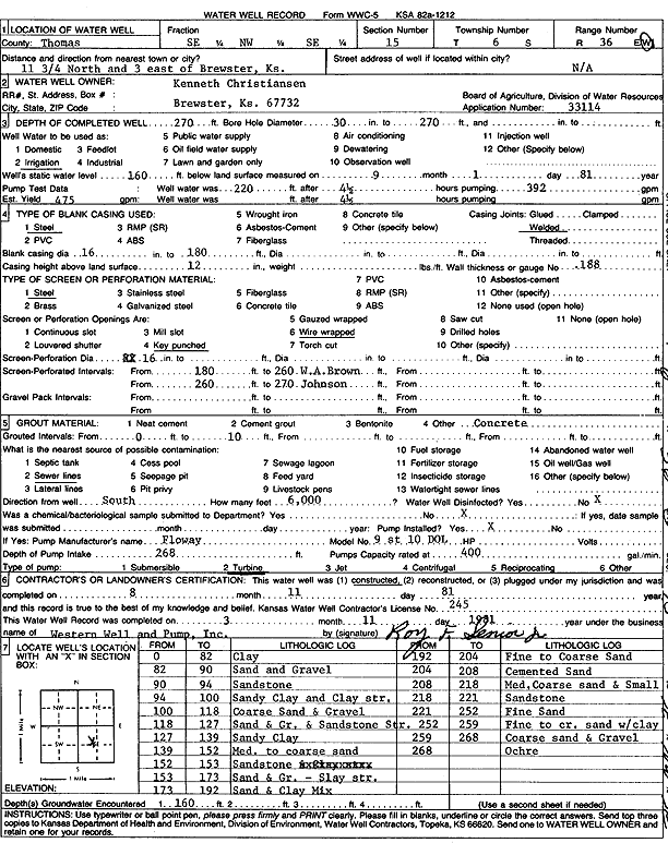
Specific Water Well Detail |
|
|
| Location Info | |||
| Owner: Christiansen, Kenneth | Status: Constructed | ||
| Location: T6S, R36W, Sec. 15, SE NW SE | County: Thomas | ||
| Directions: from Brewster: 11.75 mi N, 3 mi E | |||
| Latitude: 39.5306049 | Longitude: -101.3205797 | Datum NAD 27 | |
| Latitude: 39.5306047 | Longitude: -101.3210193 | Datum NAD 83 | |
| Longitude and latitude calculated by Survey from township-range-section-quarter calls. Only good to within the quarter call accuracy. | |||
| View well on interactive map | |||
| General Info | ||
| Well Depth: 270 ft. | Elevation: ft. | |
| Static Water Level: 160 ft. | Est. Yield: 475 gpm. | |
| Comp. Date: 11-Aug-1981 | Well Use: Irrigation | |
| DWR Applic. #: 33114 | Other ID: | |
| Links | |
| No Wizard information available. | |
| View info from WIMAS Water Right Data base... | |
| Driller Info | ||
| Driller: Roy Senior, Western Well & Pump, Inc. | License #: 245 | |
| Scanned Form | View scan |
|
Chemical Sample Submitted?: No
Water Well disinfected?: | ||
| Ground water encountered: 0 ft. , 0 ft. , 0 ft. | ||
| Pump test data: Well water was 0 ft after 0 hours pumping 0 gpm | ||
| Casing Info | ||
| Casing Type:
Casing Joints: |
Diam: 0 in. to 0 ft
Diam: 0 in. to 0 ft Diam: 0 in. to 0 ft | |
| Casing height above land surface: in
Casing Weight: lbs/ft Wall thickness or gauge no.: | ||
| Screen and Perforation Info | ||
| Screen Type: | Screen Openings: | |
| Screen-perforated intervals | From: 180 ft to 260 ft
From: 260 ft to 270 ft From: 0 ft to 0 ft | |
| Gravel pack intervals | From: ft to ft | |
| Grout Info | ||
| Grout used: | From: 0 to 0 ft
From: 0 to 0 ft From: 0 to 0 ft | |
| Source of Possible Contamination | ||
| Source: | ||
| Direction from well: | Distance: 0 ft | |
| Lithologic Log
(Log data entered by KGS.) | ||
| From: 0 ft. to 82 ft. | clay | |
| From: 82 ft. to 90 ft. | sand and gravel | |
| From: 90 ft. to 94 ft. | sandstone | |
| From: 94 ft. to 100 ft. | sandy clay and clay streaks | |
| From: 100 ft. to 118 ft. | coarse sand and gravel | |
| From: 118 ft. to 127 ft. | sand and gravel and sandstone streaks | |
| From: 127 ft. to 139 ft. | sandy clay | |
| From: 139 ft. to 152 ft. | medium to coarse sand | |
| From: 152 ft. to 153 ft. | sandstone | |
| From: 153 ft. to 173 ft. | sand and gravel, clay streaks | |
| From: 173 ft. to 192 ft. | sand and clay mix | |
| From: 192 ft. to 204 ft. | fine to coarse sand | |
| From: 204 ft. to 208 ft. | cemented sand | |
| From: 208 ft. to 218 ft. | medium coarse sand and small | |
| From: 218 ft. to 221 ft. | sandstone | |
| From: 221 ft. to 252 ft. | fine sand | |
| From: 252 ft. to 259 ft. | fine to coarse sand with clay | |
| From: 259 ft. to 268 ft. | coarse sand and gravel | |
| From: 268 ft. to ft. | ochre | |