|
|
|
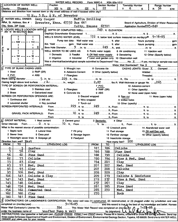
Specific Water Well Detail |
|
|
| Location Info | |||
| Owner: Murfin Drilling/Gary Cooper | Status: Constructed | ||
| Location: T6S, R36W, Sec. 22, NE SE SE | County: Thomas | ||
| Directions: from Brewster: 10 mi N, 3 mi E, .25 mi N | |||
| Latitude: 39.5142739 | Longitude: -101.3159088 | Datum NAD 27 | |
| Latitude: 39.5142741 | Longitude: -101.3163484 | Datum NAD 83 | |
| Longitude and latitude calculated by Survey from township-range-section-quarter calls. Only good to within the quarter call accuracy. | |||
| View well on interactive map | |||
| General Info | ||
| Well Depth: 249 ft. | Elevation: ft. | |
| Static Water Level: 172 ft. | Est. Yield: gpm. | |
| Comp. Date: 16-Sep-1985 | Well Use: Oil Field Water Supply | |
| DWR Applic. #: T85-840 | Other ID: | |
| Driller Info | ||
| Driller: Walter Woofter Pump & Well | License #: 394 | |
| Scanned Form | View scan |
|
Chemical Sample Submitted?: No
Water Well disinfected?: | ||
| Ground water encountered: 0 ft. , 0 ft. , 0 ft. | ||
| Pump test data: Well water was 0 ft after 0 hours pumping 0 gpm | ||
| Casing Info | ||
| Casing Type: PVC
Casing Joints: |
Diam: 5 in. to 229 ft
Diam: 0 in. to 0 ft Diam: 0 in. to 0 ft | |
| Casing height above land surface: in
Casing Weight: lbs/ft Wall thickness or gauge no.: | ||
| Screen and Perforation Info | ||
| Screen Type: PVC | Screen Openings: Saw cut | |
| Screen-perforated intervals | From: 229 ft to 249 ft
From: 0 ft to 0 ft From: 0 ft to 0 ft | |
| Gravel pack intervals | From: ft to ft | |
| Grout Info | ||
| Grout used: Bentonite | From: 0 to 10 ft
From: 0 to 0 ft From: 0 to 0 ft | |
| Source of Possible Contamination | ||
| Source: Oil well/gas well | ||
| Direction from well: | Distance: 0 ft | |
| Lithologic Log
(Log data entered by KGS.) | ||
| From: 0 ft. to 3 ft. | surface | |
| From: 3 ft. to 56 ft. | clay | |
| From: 56 ft. to 62 ft. | fine sand | |
| From: 62 ft. to 73 ft. | caliche | |
| From: 73 ft. to 83 ft. | clay | |
| From: 83 ft. to 91 ft. | medium sand | |
| From: 91 ft. to 93 ft. | clay | |
| From: 93 ft. to 106 ft. | medium sand | |
| From: 106 ft. to 141 ft. | caliche and clay | |
| From: 141 ft. to 143 ft. | medium sand | |
| From: 143 ft. to 148 ft. | caliche | |
| From: 148 ft. to 156 ft. | medium sand | |
| From: 156 ft. to 162 ft. | cemented sand | |
| From: 162 ft. to 180 ft. | clay | |
| From: 180 ft. to 181 ft. | fine sand | |
| From: 181 ft. to 186 ft. | caliche | |
| From: 186 ft. to 188 ft. | fine sand | |
| From: 188 ft. to 190 ft. | caliche | |
| From: 190 ft. to 194 ft. | fine and medium sand | |
| From: 194 ft. to 201 ft. | clay | |
| From: 201 ft. to 207 ft. | medium sand | |
| From: 207 ft. to 208 ft. | caliche | |
| From: 208 ft. to 209 ft. | clay | |
| From: 209 ft. to 219 ft. | caliche and sandstone | |
| From: 219 ft. to 237 ft. | fine and medium sand | |
| From: 237 ft. to 261 ft. | clay | |
| From: 261 ft. to 265 ft. | fine sand | |
| From: 265 ft. to 270 ft. | medium sand | |
| From: 270 ft. to ft. | rock | |