|
|
|
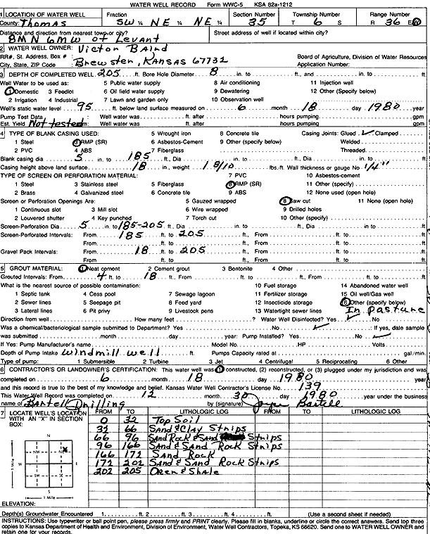
Specific Water Well Detail |
|
|
| Location Info | |||
| Owner: Baird, Victor | Status: Constructed | ||
| Location: T6S, R36W, Sec. 35, SW NE NE | County: Thomas | ||
| Directions: from Levant: 8 mi N, 6 mi W | |||
| Latitude: 39.494377 | Longitude: -101.2997666 | Datum NAD 27 | |
| Latitude: 39.4943775 | Longitude: -101.3002058 | Datum NAD 83 | |
| Longitude and latitude calculated by Survey from township-range-section-quarter calls. Only good to within the quarter call accuracy. | |||
| View well on interactive map | |||
| General Info | ||
| Well Depth: 205 ft. | Elevation: ft. | |
| Static Water Level: 95 ft. | Est. Yield: gpm. | |
| Comp. Date: 18-Jun-1980 | Well Use: Domestic | |
| DWR Applic. #: | Other ID: | |
| Driller Info | ||
| Driller: Robert Bartell Drilling & Machine Works | License #: 139 | |
| Scanned Form | View scan |
|
Chemical Sample Submitted?: No
Water Well disinfected?: | ||
| Ground water encountered: 0 ft. , 0 ft. , 0 ft. | ||
| Pump test data: Well water was 0 ft after 0 hours pumping 0 gpm | ||
| Casing Info | ||
| Casing Type:
Casing Joints: |
Diam: 0 in. to 0 ft
Diam: 0 in. to 0 ft Diam: 0 in. to 0 ft | |
| Casing height above land surface: in
Casing Weight: lbs/ft Wall thickness or gauge no.: | ||
| Screen and Perforation Info | ||
| Screen Type: | Screen Openings: | |
| Screen-perforated intervals | From: 185 ft to 205 ft
From: 0 ft to 0 ft From: 0 ft to 0 ft | |
| Gravel pack intervals | From: ft to ft | |
| Grout Info | ||
| Grout used: | From: 0 to 0 ft
From: 0 to 0 ft From: 0 to 0 ft | |
| Source of Possible Contamination | ||
| Source: | ||
| Direction from well: | Distance: 0 ft | |
| Lithologic Log
(Log data entered by KGS.) | ||
| From: 0 ft. to 32 ft. | top soil | |
| From: 32 ft. to 66 ft. | sand and clay strips | |
| From: 66 ft. to 96 ft. | sand rock and sand strips | |
| From: 96 ft. to 166 ft. | sand and sand rock strips | |
| From: 166 ft. to 171 ft. | sand rock | |
| From: 171 ft. to 202 ft. | sand and sand rock strips | |
| From: 202 ft. to 205 ft. | ochre and shale | |