|
|
|
Specific Water Well Detail |
|
|
| Location Info | |||
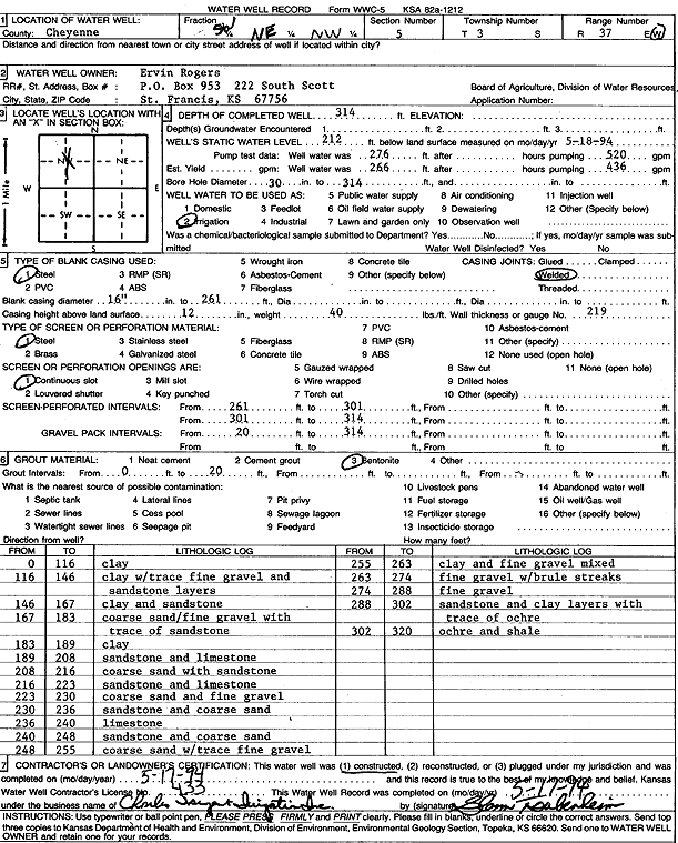
| Owner: Rogers, Ervin | Status: Constructed | ||
| Location: T3S, R37W, Sec. 5, SW NE NW | County: Cheyenne | ||
| Directions: | |||
| Latitude: 39.8266682 | Longitude: -101.4975534 | Datum NAD 27 | |
| Latitude: 39.8266639 | Longitude: -101.4979963 | Datum NAD 83 | |
| Longitude and latitude calculated by Survey from township-range-section-quarter calls. Only good to within the quarter call accuracy. | |||
| View well on interactive map | |||
| General Info | ||
| Well Depth: 314 ft. | Elevation: ft. | |
| Static Water Level: 212 ft. | Est. Yield: gpm. | |
| Comp. Date: 17-May-1994 | Well Use: Irrigation | |
| DWR Applic. #: | Other ID: | |
| Links | |
| No Wizard information available. | |
| View info from WIMAS Water Right Data base... | |
| Driller Info | ||
| Driller: Chas. Sargent Irrigation Co., Inc. | License #: 433 | |
| Scanned Form | View scan |
|
Chemical Sample Submitted?: No
Water Well disinfected?: | ||
| Ground water encountered: 0 ft. , 0 ft. , 0 ft. | ||
| Pump test data: Well water was 276 ft after 0 hours pumping 520 gpm | ||
| Casing Info | ||
| Casing Type: Steel
Casing Joints: |
Diam: 16 in. to 261 ft
Diam: 0 in. to 0 ft Diam: 0 in. to 0 ft | |
| Casing height above land surface: in
Casing Weight: lbs/ft Wall thickness or gauge no.: | ||
| Screen and Perforation Info | ||
| Screen Type: Steel | Screen Openings: Continuous slot | |
| Screen-perforated intervals | From: 261 ft to 301 ft
From: 301 ft to 314 ft From: 0 ft to 0 ft | |
| Gravel pack intervals | From: ft to ft | |
| Grout Info | ||
| Grout used: Bentonite | From: 0 to 20 ft
From: 0 to 0 ft From: 0 to 0 ft | |
| Source of Possible Contamination | ||
| Source: OTHER | ||
| Direction from well: | Distance: 0 ft | |
| Lithologic Log
(Log data entered by KGS.) | ||
| From: 0 ft. to 116 ft. | Clay | |
| From: 116 ft. to 146 ft. | Clay with trace fine gravel and sandstone layers | |
| From: 146 ft. to 167 ft. | Clay and sandstone | |
| From: 167 ft. to 183 ft. | Coarse sand and fine gravel with traces of sandstone | |
| From: 183 ft. to 189 ft. | Clay | |
| From: 189 ft. to 208 ft. | Sandstone and limestone | |
| From: 208 ft. to 216 ft. | Coarse sand with sandstone | |
| From: 216 ft. to 223 ft. | Sandstone and limestone | |
| From: 223 ft. to 230 ft. | Coarse sand and fine gravel | |
| From: 230 ft. to 236 ft. | Sandstone and coarse sand | |
| From: 236 ft. to 240 ft. | Limestone | |
| From: 240 ft. to 248 ft. | Sandstone and coarse sand | |
| From: 248 ft. to 255 ft. | Coarse sand with trace fine gravel | |
| From: 255 ft. to 263 ft. | Clay and fine gravel mixed | |
| From: 263 ft. to 274 ft. | Fine gravel with brule streaks | |
| From: 274 ft. to 288 ft. | Fine gravel | |
| From: 288 ft. to 302 ft. | Sandstone and clay layers with trace of ochre | |
| From: 302 ft. to 320 ft. | Ochre and shale | |