|
|
|
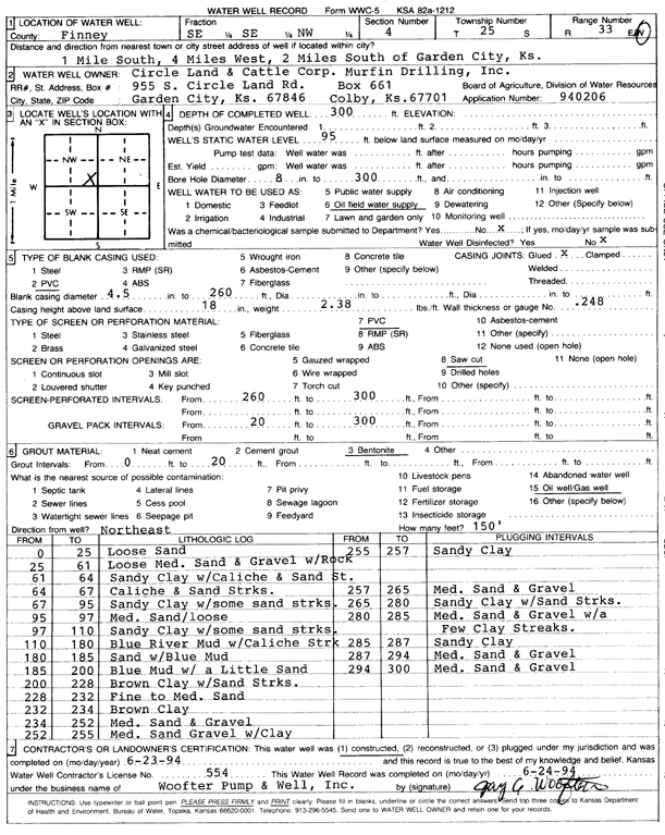
Specific Water Well Detail |
|
|
| Location Info | |||
| Owner: Murfin Drilling/Circle Land and Cattle Co. | Status: Constructed | ||
| Location: T25S, R33W, Sec. 4, SE SE NW | County: Finney | ||
| Directions: from Garden City, 1 mi S, 4 mi W, and 2 mi S | |||
| Latitude: 37.9104636 | Longitude: -100.9481469 | Datum NAD 27 | |
| Latitude: 37.9104873 | Longitude: -100.9485902 | Datum NAD 83 | |
| Longitude and latitude calculated by Survey from township-range-section-quarter calls. Only good to within the quarter call accuracy. | |||
| View well on interactive map | |||
| General Info | ||
| Well Depth: 300 ft. | Elevation: ft. | |
| Static Water Level: 95 ft. | Est. Yield: gpm. | |
| Comp. Date: 23-Jun-1994 | Well Use: Oil Field Water Supply | |
| DWR Applic. #: 940206 | Other ID: | |
| Links | |
| No Wizard information available. | |
| View info from WIMAS Water Right Data base... | |
| Driller Info | ||
| Driller: Jay C. Woofter Pump & Well, Inc. | License #: 554 | |
| Scanned Form | View scan |
|
Chemical Sample Submitted?: No
Water Well disinfected?: | ||
| Ground water encountered: 0 ft. , 0 ft. , 0 ft. | ||
| Pump test data: Well water was 0 ft after 0 hours pumping 0 gpm | ||
| Casing Info | ||
| Casing Type: PVC
Casing Joints: |
Diam: 4 in. to 260 ft
Diam: 0 in. to 0 ft Diam: 0 in. to 0 ft | |
| Casing height above land surface: in
Casing Weight: lbs/ft Wall thickness or gauge no.: | ||
| Screen and Perforation Info | ||
| Screen Type: PVC | Screen Openings: Saw cut | |
| Screen-perforated intervals | From: 260 ft to 300 ft
From: 0 ft to 0 ft From: 0 ft to 0 ft | |
| Gravel pack intervals | From: ft to ft | |
| Grout Info | ||
| Grout used: Bentonite | From: 0 to 20 ft
From: 0 to 0 ft From: 0 to 0 ft | |
| Source of Possible Contamination | ||
| Source: Oil well/gas well | ||
| Direction from well: | Distance: 0 ft | |
| Lithologic Log
(Log data entered by KGS.) | ||
| From: 0 ft. to 25 ft. | loose sand | |
| From: 25 ft. to 61 ft. | loose medium sand and gravel with rock | |
| From: 61 ft. to 64 ft. | sandy clay with caliche and sand st. | |
| From: 64 ft. to 67 ft. | caliche and sand streaks | |
| From: 67 ft. to 95 ft. | sandy clay with some sand streaks | |
| From: 95 ft. to 97 ft. | medium sand / loose | |
| From: 97 ft. to 110 ft. | sandy clay with some sand streaks | |
| From: 110 ft. to 180 ft. | blue river mud with caliche strk | |
| From: 180 ft. to 185 ft. | sand with blue mud | |
| From: 185 ft. to 200 ft. | blue mud with a little sand | |
| From: 200 ft. to 228 ft. | brown clay with sand streaks | |
| From: 228 ft. to 232 ft. | fine to medium sand | |
| From: 232 ft. to 234 ft. | brown clay | |
| From: 234 ft. to 252 ft. | medium sand and gravel | |
| From: 252 ft. to 255 ft. | medium sand gravel with clay | |
| From: 255 ft. to 257 ft. | sandy clay | |
| From: 257 ft. to 265 ft. | medium sand and gravel | |
| From: 265 ft. to 280 ft. | sandy clay with sand streaks | |
| From: 280 ft. to 285 ft. | medium sand and gravel with a few clay streaks. | |
| From: 285 ft. to 287 ft. | sandy clay | |
| From: 287 ft. to 294 ft. | medium sand and gravel | |
| From: 294 ft. to 300 ft. | medium sand and gravel | |