|
|
|
Specific Water Well Detail |
|
|
| Location Info | |||
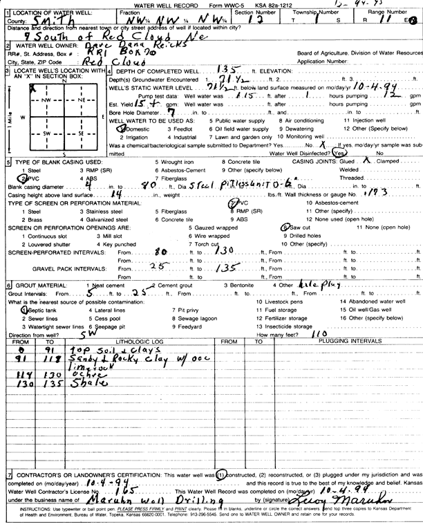
| Owner: Reicks, Dave and Dana | Status: Constructed | ||
| Location: T1S, R11W, Sec. 12, NW NW NW | County: Smith | ||
| Directions: from Red Cloud, NE, 7 mi S | |||
| Latitude: 39.9867662 | Longitude: -98.5218856 | Datum NAD 27 | |
| Latitude: 39.9867798 | Longitude: -98.5222233 | Datum NAD 83 | |
| Longitude and latitude calculated by Survey from township-range-section-quarter calls. Only good to within the quarter call accuracy. | |||
| View well on interactive map | |||
| General Info | ||
| Well Depth: 135 ft. | Elevation: ft. | |
| Static Water Level: 71.5 ft. | Est. Yield: 15 gpm. | |
| Comp. Date: 04-Oct-1994 | Well Use: Domestic | |
| DWR Applic. #: | Other ID: | |
| Driller Info | ||
| Driller: Leroy Maruhn Well Drilling, Inc. | License #: 165 | |
| Scanned Form | View scan |
|
Chemical Sample Submitted?: No
Water Well disinfected?: | ||
| Ground water encountered: 71 ft. , 0 ft. , 0 ft. | ||
| Pump test data: Well water was 115 ft after 1 hours pumping 12 gpm | ||
| Casing Info | ||
| Casing Type: PVC
Casing Joints: |
Diam: 4 in. to 80 ft
Diam: 0 in. to 0 ft Diam: 0 in. to 0 ft | |
| Casing height above land surface: in
Casing Weight: lbs/ft Wall thickness or gauge no.: | ||
| Screen and Perforation Info | ||
| Screen Type: PVC | Screen Openings: Saw cut | |
| Screen-perforated intervals | From: 80 ft to 130 ft
From: 0 ft to 0 ft From: 0 ft to 0 ft | |
| Gravel pack intervals | From: ft to ft | |
| Grout Info | ||
| Grout used: | From: 5 to 25 ft
From: 0 to 0 ft From: 0 to 0 ft | |
| Source of Possible Contamination | ||
| Source: Septic Tank | ||
| Direction from well: | Distance: 0 ft | |
| Lithologic Log
(Log data entered by KGS.) | ||
| From: 0 ft. to 91 ft. | top soil and clays | |
| From: 91 ft. to 118 ft. | sandy and rocky clay with occasional lime rock | |
| From: 118 ft. to 130 ft. | ochre | |
| From: 130 ft. to 135 ft. | shale | |