|
|
|
Specific Water Well Detail |
|
|
| Location Info | |||
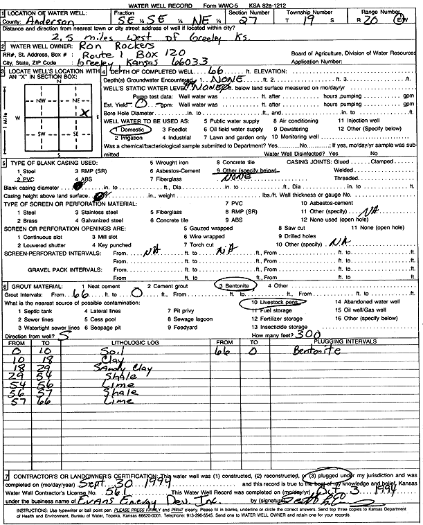
| Owner: Rockers, Ron | Status: Plugged | ||
| Location: T19S, R20E, Sec. 27, SE SE NE | County: Anderson | ||
| Directions: from Greeley: 2.5 mi W | |||
| Latitude: 38.3691667 | Longitude: -95.1769422 | Datum NAD 27 | |
| Latitude: 38.3691858 | Longitude: -95.1771924 | Datum NAD 83 | |
| Longitude and latitude calculated by Survey from township-range-section-quarter calls. Only good to within the quarter call accuracy. | |||
| View well on interactive map | |||
| General Info | ||
| Well Depth: 66 ft. | Elevation: ft. | |
| Static Water Level: ft. | Est. Yield: gpm. | |
| Comp. Date: 30-Sep-1994 | Well Use: Domestic | |
| DWR Applic. #: | Other ID: | |
| Driller Info | ||
| Driller: Evans Energy Development, Inc. | License #: 561 | |
| Scanned Form | View scan |
| Casing Info | ||
|
Casing Type: PVC
Diam: 0 in. Casing height above land surface: in | ||
| Grout Info | ||
| Grout used: Bentonite | From: 0 to 66 ft
From: 0 to 0 ft From: 0 to 0 ft | |
| Source of Possible Contamination | ||
| Source: Livestock pens | ||
| Direction from well: | Distance: 0 ft | |
| Lithologic Log
(Log data entered by KGS.) | ||
| From: 0 ft. to 10 ft. | soil | |
| From: 10 ft. to 18 ft. | clay | |
| From: 18 ft. to 29 ft. | sandy clay | |
| From: 29 ft. to 54 ft. | shale | |
| From: 54 ft. to 56 ft. | limestone | |
| From: 56 ft. to 57 ft. | shale | |
| From: 57 ft. to 66 ft. | limestone | |