|
|
|
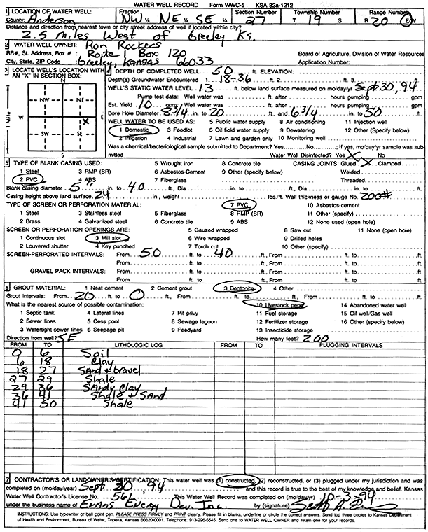
Specific Water Well Detail |
|
|
| Location Info | |||
| Owner: Rockers, Ron | Status: Constructed | ||
| Location: T19S, R20E, Sec. 27, NW NE SE | County: Anderson | ||
| Directions: from Greeley: 2.5 mi W | |||
| Latitude: 38.3673392 | Longitude: -95.1792169 | Datum NAD 27 | |
| Latitude: 38.3673583 | Longitude: -95.1794672 | Datum NAD 83 | |
| Longitude and latitude calculated by Survey from township-range-section-quarter calls. Only good to within the quarter call accuracy. | |||
| View well on interactive map | |||
| General Info | ||
| Well Depth: 50 ft. | Elevation: ft. | |
| Static Water Level: 13 ft. | Est. Yield: 10 gpm. | |
| Comp. Date: 30-Sep-1994 | Well Use: Domestic | |
| DWR Applic. #: | Other ID: | |
| Driller Info | ||
| Driller: Evans Energy Development, Inc. | License #: 561 | |
| Scanned Form | View scan |
|
Chemical Sample Submitted?: No
Water Well disinfected?: | ||
| Ground water encountered: 18 ft. , 0 ft. , 0 ft. | ||
| Pump test data: Well water was 0 ft after 0 hours pumping 0 gpm | ||
| Casing Info | ||
| Casing Type: PVC
Casing Joints: |
Diam: 5 in. to 40 ft
Diam: 0 in. to 0 ft Diam: 0 in. to 0 ft | |
| Casing height above land surface: in
Casing Weight: lbs/ft Wall thickness or gauge no.: | ||
| Screen and Perforation Info | ||
| Screen Type: PVC | Screen Openings: Mill slot | |
| Screen-perforated intervals | From: 40 ft to 50 ft
From: 0 ft to 0 ft From: 0 ft to 0 ft | |
| Gravel pack intervals | From: ft to ft | |
| Grout Info | ||
| Grout used: Bentonite | From: 0 to 20 ft
From: 0 to 0 ft From: 0 to 0 ft | |
| Source of Possible Contamination | ||
| Source: Livestock pens | ||
| Direction from well: | Distance: 0 ft | |
| Lithologic Log
(Log data entered by KGS.) | ||
| From: 0 ft. to 6 ft. | Soil | |
| From: 6 ft. to 18 ft. | Clay | |
| From: 18 ft. to 27 ft. | Sand and gravel | |
| From: 27 ft. to 29 ft. | Shale | |
| From: 29 ft. to 36 ft. | Sandy clay | |
| From: 36 ft. to 41 ft. | Shale and sand | |
| From: 41 ft. to 50 ft. | Shale | |