|
|
|
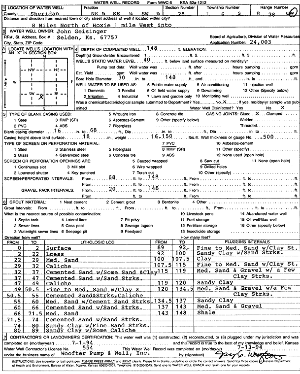
Specific Water Well Detail |
|
|
| Location Info | |||
| Owner: Geisinger, John | Status: Reconstructed | ||
| Location: T6S, R28W, Sec. 28, NE SE SW | County: Sheridan | ||
| Directions: from Hoxie: 8 mi N, 1 mi W into site | |||
| Latitude: 39.4981307 | Longitude: -100.4517436 | Datum NAD 27 | |
| Latitude: 39.4981345 | Longitude: -100.4521626 | Datum NAD 83 | |
| Longitude and latitude calculated by Survey from township-range-section-quarter calls. Only good to within the quarter call accuracy. | |||
| View well on interactive map | |||
| General Info | ||
| Well Depth: 148 ft. | Elevation: ft. | |
| Static Water Level: 40 ft. | Est. Yield: gpm. | |
| Comp. Date: 01-Jul-1994 | Well Use: Irrigation | |
| DWR Applic. #: 24,003 | Other ID: | |
| Links | |
| View info from Wizard Water Level Data base... | |
| View info from WIMAS Water Right Data base... | |
| Driller Info | ||
| Driller: Woofter Pump & Well, Inc. | License #: 554 | |
| Scanned Form | View scan |
|
Chemical Sample Submitted?: No
Water Well disinfected?: No | ||
| Ground water encountered: 0 ft. , 0 ft. , 0 ft. | ||
| Pump test data: Well water was 0 ft after 0 hours pumping 0 gpm | ||
| Bore hole diameter: 30 inches to 148 ft | ||
| Casing Info | ||
| Casing Type: PVC
Casing Joints: Glued |
Diam: 16 in. to 68 ft
Diam: 0 in. to 0 ft Diam: 0 in. to 0 ft | |
| Casing height above land surface: 18 in
Casing Weight: 16.15 lbs/ft Wall thickness or gauge no.: .500 | ||
| Screen and Perforation Info | ||
| Screen Type: PVC | Screen Openings: Saw cut | |
| Screen-perforated intervals | From: 68 ft to 148 ft
From: 0 ft to 0 ft From: 0 ft to 0 ft | |
| Gravel pack intervals | From: 20 ft to 148 ft | |
| Grout Info | ||
| Grout used: Cement grout | From: 0 to 20 ft
From: 0 to 0 ft From: 0 to 0 ft | |
| Source of Possible Contamination | ||
| Source: OTHER | ||
| Direction from well: | Distance: 0 ft | |
| Lithologic Log
(Log data entered by KGS.) | ||
| From: 0 ft. to 2 ft. | Surface | |
| From: 2 ft. to 22 ft. | Loess | |
| From: 22 ft. to 29 ft. | Medium sand | |
| From: 29 ft. to 32 ft. | Caliche | |
| From: 32 ft. to 37 ft. | Cemented sand with some sand and clay | |
| From: 37 ft. to 47 ft. | Cemented sand with sand streaks | |
| From: 47 ft. to 49 ft. | Caliche | |
| From: 49 ft. to 50.5 ft. | Fine to medium sand with clay clay | |
| From: 50.5 ft. to 55 ft. | Cemented sand and caliche streaks | |
| From: 55 ft. to 60 ft. | Medium sand with cement sand streaks | |
| From: 60 ft. to 66 ft. | Cemented sand with sand streaks | |
| From: 66 ft. to 71.5 ft. | Medium sand | |
| From: 71.5 ft. to 74 ft. | Cemented sand with sand streaks | |
| From: 74 ft. to 80 ft. | Sandy clay with fine sand streaks | |
| From: 80 ft. to 89 ft. | Sandy clay with some caliche | |
| From: 89 ft. to 92 ft. | Fine to medium sand with clay streaks | |
| From: 92 ft. to 100 ft. | Sandy clay with sand streaks | |
| From: 100 ft. to 107.5 ft. | Clay | |
| From: 107.5 ft. to 115 ft. | Fine to medium sand with clay streaks | |
| From: 115 ft. to 119 ft. | Medium sand and gravel with a few clay streaks | |
| From: 119 ft. to 120 ft. | Sandy clay | |
| From: 120 ft. to 134.5 ft. | Medium sand and gravel with a few clay streaks | |
| From: 134.5 ft. to 137 ft. | Sandy clay | |
| From: 137 ft. to 143 ft. | Medium sand and gravel | |
| From: 143 ft. to 148 ft. | Shale | |