|
|
|
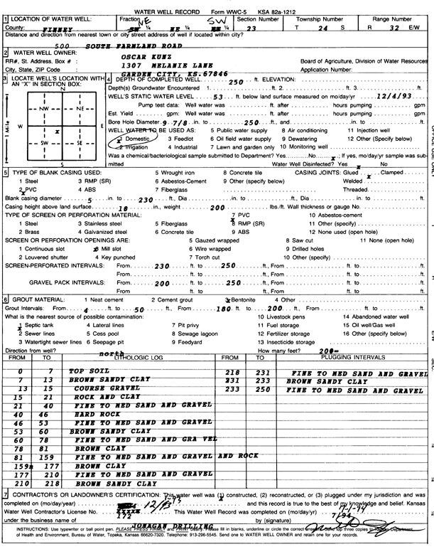
Specific Water Well Detail |
|
|
| Location Info | |||
| Owner: Kunz, Oscar | Status: Constructed | ||
| Location: T24S, R32W, Sec. 23, NE NE SW | County: Finney | ||
| Directions: 500 S Farmland Rd | |||
| Latitude: 37.9521015 | Longitude: -100.8022786 | Datum NAD 27 | |
| Latitude: 37.9521241 | Longitude: -100.8027156 | Datum NAD 83 | |
| Longitude and latitude calculated by Survey from township-range-section-quarter calls. Only good to within the quarter call accuracy. | |||
| View well on interactive map | |||
| General Info | ||
| Well Depth: 250 ft. | Elevation: ft. | |
| Static Water Level: 53 ft. | Est. Yield: gpm. | |
| Comp. Date: 01-Dec-1993 | Well Use: Domestic | |
| DWR Applic. #: | Other ID: | |
| Driller Info | ||
| Driller: Jonagan Water Well Service LLC | License #: 172 | |
| Scanned Form | View scan |
|
Chemical Sample Submitted?: No
Water Well disinfected?: | ||
| Ground water encountered: 0 ft. , 0 ft. , 0 ft. | ||
| Pump test data: Well water was 0 ft after 0 hours pumping 0 gpm | ||
| Casing Info | ||
| Casing Type: PVC
Casing Joints: |
Diam: 5 in. to 230 ft
Diam: 0 in. to 0 ft Diam: 0 in. to 0 ft | |
| Casing height above land surface: in
Casing Weight: lbs/ft Wall thickness or gauge no.: | ||
| Screen and Perforation Info | ||
| Screen Type: PVC | Screen Openings: Mill slot | |
| Screen-perforated intervals | From: 230 ft to 250 ft
From: 0 ft to 0 ft From: 0 ft to 0 ft | |
| Gravel pack intervals | From: ft to ft | |
| Grout Info | ||
| Grout used: Bentonite | From: 4 to 50 ft
From: 180 to 200 ft From: 0 to 0 ft | |
| Source of Possible Contamination | ||
| Source: Septic Tank | ||
| Direction from well: | Distance: 0 ft | |
| Lithologic Log
(Log data entered by KGS.) | ||
| From: 0 ft. to 7 ft. | top soil | |
| From: 7 ft. to 13 ft. | brown sandy clay | |
| From: 13 ft. to 15 ft. | coarse gravel | |
| From: 15 ft. to 21 ft. | rock and clay | |
| From: 21 ft. to 40 ft. | fine to medium sand and gravel | |
| From: 40 ft. to 46 ft. | hard rock | |
| From: 46 ft. to 53 ft. | fine to medium sand and gravel | |
| From: 53 ft. to 60 ft. | brown sandy clay | |
| From: 60 ft. to 78 ft. | fine to medium sand and gra vel | |
| From: 78 ft. to 81 ft. | brown clay | |
| From: 81 ft. to 159 ft. | fine to medium sand and gravel and rock | |
| From: 159 ft. to 177 ft. | brown clay | |
| From: 177 ft. to 210 ft. | fine to medium sand and gravel | |
| From: 210 ft. to 218 ft. | brown sandy clay | |
| From: 218 ft. to 231 ft. | fine to medium sand and gravel | |
| From: 231 ft. to 233 ft. | brown sandy clay | |
| From: 233 ft. to 250 ft. | fine to medium sand and gravel | |