|
|
|
Specific Water Well Detail |
|
|
| Location Info | |||
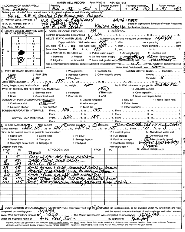
| Owner: U.S. Army Corps of Engineers | Status: Constructed | ||
| Location: T24S, R31W, Sec. 34, NW SE SW | County: Finney | ||
| Directions: from Garden City Municipal Airport, 0.25 mi SE | |||
| Latitude: 37.9187844 | Longitude: -100.713486 | Datum NAD 27 | |
| Latitude: 37.9188067 | Longitude: -100.71392 | Datum NAD 83 | |
| Longitude and latitude calculated by Survey from township-range-section-quarter calls. Only good to within the quarter call accuracy. | |||
| View well on interactive map | |||
| General Info | ||
| Well Depth: 135 ft. | Elevation: ft. | |
| Static Water Level: 130 ft. | Est. Yield: gpm. | |
| Comp. Date: 14-Nov-1994 | Well Use: Monitoring well/observation/piezometer | |
| DWR Applic. #: | Other ID: | |
| Driller Info | ||
| Driller: A. W. Pool, Inc. | License #: 555 | |
| Scanned Form | View scan |
|
Chemical Sample Submitted?: No
Water Well disinfected?: | ||
| Ground water encountered: 130 ft. , 0 ft. , 0 ft. | ||
| Pump test data: Well water was 0 ft after 0 hours pumping 0 gpm | ||
| Casing Info | ||
| Casing Type: PVC
Casing Joints: |
Diam: 2 in. to 135 ft
Diam: 0 in. to 0 ft Diam: 0 in. to 0 ft | |
| Casing height above land surface: in
Casing Weight: lbs/ft Wall thickness or gauge no.: | ||
| Screen and Perforation Info | ||
| Screen Type: PVC | Screen Openings: Mill slot | |
| Screen-perforated intervals | From: 125 ft to 135 ft
From: 0 ft to 0 ft From: 0 ft to 0 ft | |
| Gravel pack intervals | From: ft to ft | |
| Grout Info | ||
| Grout used: Cement grout, Bentonite | From: 0 to 3 ft
From: 3 to 115 ft From: 115 to 120 ft | |
| Source of Possible Contamination | ||
| Source: OTHER | ||
| Direction from well: | Distance: 0 ft | |
| Lithologic Log
(Log data entered by KGS.) | ||
| From: 0 ft. to 1 ft. | topsoil | |
| From: 1 ft. to 5 ft. | clay with silt, dry firm caliche | |
| From: 5 ft. to 20 ft. | sand and clay, some caliche | |
| From: 20 ft. to 29 ft. | caliche, firm | |
| From: 29 ft. to 45 ft. | sand trace gravel, cemented caliche brown | |
| From: 45 ft. to 60 ft. | gravel, some sand, loose to medium dense | |
| From: 60 ft. to 75 ft. | sand, fine grained, well sorted, dry | |
| From: 75 ft. to 101 ft. | sand, trace gravel, with clay yellowish brown | |
| From: 101 ft. to 135 ft. | sand, moist, medium dense, yellowish brown, caliche | |