|
|
|
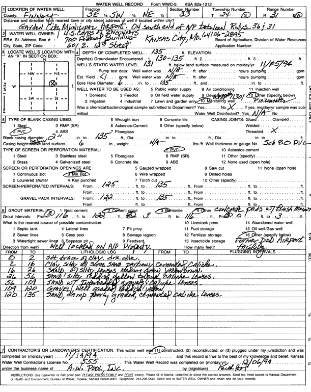
Specific Water Well Detail |
|
|
| Location Info | |||
| Owner: U.S. Corps of Engineers | Status: Constructed | ||
| Location: T24S, R31W, Sec. 33, SE SW NE | County: Finney | ||
| Directions: on S end of airport between runways 31 and 36 | |||
| Latitude: 37.9242852 | Longitude: -100.7248074 | Datum NAD 27 | |
| Latitude: 37.9243074 | Longitude: -100.7252417 | Datum NAD 83 | |
| Longitude and latitude calculated by Survey from township-range-section-quarter calls. Only good to within the quarter call accuracy. | |||
| View well on interactive map | |||
| General Info | ||
| Well Depth: 135 ft. | Elevation: ft. | |
| Static Water Level: 131 ft. | Est. Yield: gpm. | |
| Comp. Date: 14-Nov-1994 | Well Use: Monitoring well/observation/piezometer | |
| DWR Applic. #: | Other ID: | |
| Driller Info | ||
| Driller: A.W. Pool, Inc. | License #: 555 | |
| Scanned Form | View scan |
|
Chemical Sample Submitted?: No
Water Well disinfected?: | ||
| Ground water encountered: 130 ft. , 0 ft. , 0 ft. | ||
| Pump test data: Well water was 0 ft after 0 hours pumping 0 gpm | ||
| Casing Info | ||
| Casing Type: PVC
Casing Joints: |
Diam: 2 in. to 135 ft
Diam: 0 in. to 0 ft Diam: 0 in. to 0 ft | |
| Casing height above land surface: in
Casing Weight: lbs/ft Wall thickness or gauge no.: | ||
| Screen and Perforation Info | ||
| Screen Type: PVC | Screen Openings: Mill slot | |
| Screen-perforated intervals | From: 125 ft to 135 ft
From: 0 ft to 0 ft From: 0 ft to 0 ft | |
| Gravel pack intervals | From: ft to ft | |
| Grout Info | ||
| Grout used: Cement grout, Bentonite | From: 0 to 3 ft
From: 3 to 116 ft From: 116 to 122 ft | |
| Source of Possible Contamination | ||
| Source: OTHER | ||
| Direction from well: | Distance: 0 ft | |
| Lithologic Log
(Log data entered by KGS.) | ||
| From: 0 ft. to 2 ft. | silt, trace of clay, dark olive | |
| From: 2 ft. to 16 ft. | clay, silty with some sand partially cemented caliche | |
| From: 16 ft. to 26 ft. | sand, with silty lenses, medium grain yellow brown | |
| From: 26 ft. to 56 ft. | sand, silty reddish yellow to pink, caliche lenses | |
| From: 56 ft. to 109 ft. | sand with interbedded gravels, caliche lenses | |
| From: 109 ft. to 120 ft. | gravel, well graded, reddish yellow | |
| From: 120 ft. to 135 ft. | sand, damp poorly graded, cemented caliche lenses | |