|
|
|
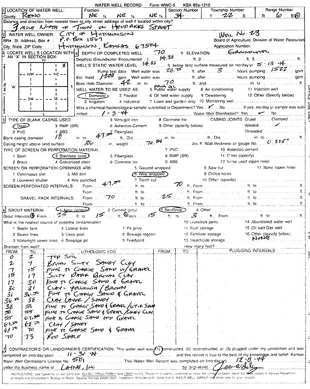
Specific Water Well Detail |
|
|
| Location Info | |||
| Owner: City of Hutchinson | Status: Constructed | ||
| Location: T22S, R6W, Sec. 34, NE NE NE | County: Reno | ||
| Directions: from town: 3 mi N on Hendricks St | |||
| Latitude: 38.0992432 | Longitude: -97.9602322 | Datum NAD 27 | |
| Latitude: 38.0992543 | Longitude: -97.9605627 | Datum NAD 83 | |
| Longitude and latitude calculated by Survey from township-range-section-quarter calls. Only good to within the quarter call accuracy. | |||
| View well on interactive map | |||
| General Info | ||
| Well Depth: 70 ft. | Elevation: ft. | |
| Static Water Level: 14.33 ft. | Est. Yield: 1200 gpm. | |
| Comp. Date: 30-Nov-1994 | Well Use: Domestic | |
| DWR Applic. #: | Other ID: Well 23 | |
| Driller Info | ||
| Driller: Layne Western | License #: 581 | |
| Scanned Form | View scan |
|
Chemical Sample Submitted?: Yes
Water Well disinfected?: | ||
| Ground water encountered: 14.33 ft. , 0 ft. , 0 ft. | ||
| Pump test data: Well water was 28.75 ft after 3 hours pumping 15.22 gpm | ||
| Casing Info | ||
| Casing Type: Steel
Casing Joints: |
Diam: 18 in. to 47.5 ft
Diam: 0 in. to 0 ft Diam: 0 in. to 0 ft | |
| Casing height above land surface: in
Casing Weight: lbs/ft Wall thickness or gauge no.: | ||
| Screen and Perforation Info | ||
| Screen Type: Stainless Steel | Screen Openings: Wire wrapped | |
| Screen-perforated intervals | From: 25.5 ft to 47.3 ft
From: 0 ft to 0 ft From: 0 ft to 0 ft | |
| Gravel pack intervals | From: ft to ft | |
| Grout Info | ||
| Grout used: Neat cement, Bentonite | From: 3 to 15 ft
From: 15 to 25 ft From: 0 to 0 ft | |
| Source of Possible Contamination | ||
| Source: OTHER | ||
| Direction from well: | Distance: 0 ft | |
| Lithologic Log
(Log data entered by KGS.) | ||
| From: 0 ft. to 2 ft. | top soil | |
| From: 2 ft. to 7 ft. | brown silty sandy clay | |
| From: 7 ft. to 15 ft. | fine to coarse sand with gravel | |
| From: 15 ft. to 17 ft. | silty dark brown clay | |
| From: 17 ft. to 30 ft. | fine to coarse sand and gravel | |
| From: 30 ft. to 31 ft. | clay, yellowish brown | |
| From: 31 ft. to 36.5 ft. | fine to coarse sand and gravel | |
| From: 36.5 ft. to 50 ft. | fine to coarse sand and gravel | |
| From: 50 ft. to 55 ft. | fine to coarse sand and gravel and sandy clay | |
| From: 55 ft. to 67.5 ft. | fine to coarse sand and gravel | |
| From: 67.5 ft. to 68.5 ft. | sandy clay | |
| From: 68.5 ft. to 70 ft. | fine to coarse sand and gravel | |
| From: 70 ft. to 73 ft. | red shale | |