|
|
|
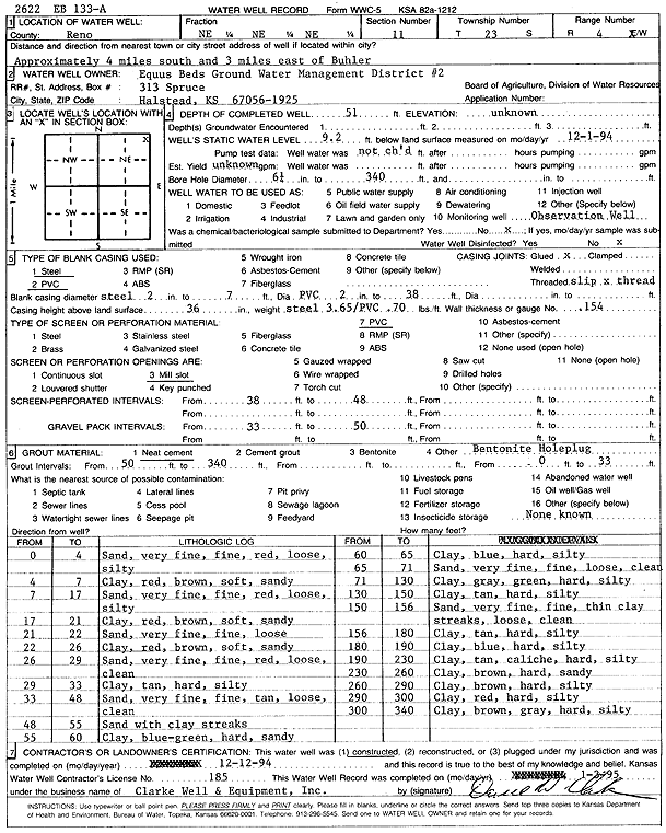
Specific Water Well Detail |
|
|
| Location Info | |||
| Owner: Equus Beds GMD 2 | Status: Constructed | ||
| Location: T23S, R4W, Sec. 11, NE NE NE | County: Reno | ||
| Directions: from Buhler: 4 mi S, 3 mi E | |||
| Latitude: 38.0712546 | Longitude: -97.7211768 | Datum NAD 27 | |
| Latitude: 38.0712653 | Longitude: -97.7215012 | Datum NAD 83 | |
| Longitude and latitude calculated by Survey from township-range-section-quarter calls. Only good to within the quarter call accuracy. | |||
| View well on interactive map | |||
| General Info | ||
| Well Depth: 51 ft. | Elevation: ft. | |
| Static Water Level: 9.2 ft. | Est. Yield: gpm. | |
| Comp. Date: 12-Dec-1994 | Well Use: Monitoring well/observation/piezometer | |
| DWR Applic. #: | Other ID: EB 133A | |
| Links | |
| View info from Wizard Water Level Data base... | |
| No WIMAS information available. | |
| Driller Info | ||
| Driller: Clarke Well and Equipment, Inc. | License #: 185 | |
| Scanned Form | View scan |
|
Chemical Sample Submitted?: No
Water Well disinfected?: | ||
| Ground water encountered: 0 ft. , 0 ft. , 0 ft. | ||
| Pump test data: Well water was 0 ft after 0 hours pumping 0 gpm | ||
| Casing Info | ||
| Casing Type: Steel
Casing Joints: |
Diam: 2 in. to 7 ft
Diam: 0 in. to 0 ft Diam: 0 in. to 0 ft | |
| Casing height above land surface: in
Casing Weight: lbs/ft Wall thickness or gauge no.: | ||
| Screen and Perforation Info | ||
| Screen Type: PVC | Screen Openings: Mill slot | |
| Screen-perforated intervals | From: 38 ft to 48 ft
From: 0 ft to 0 ft From: 0 ft to 0 ft | |
| Gravel pack intervals | From: ft to ft | |
| Grout Info | ||
| Grout used: Neat cement, | From: 0 to 33 ft
From: 50 to 340 ft From: 0 to 0 ft | |
| Source of Possible Contamination | ||
| Source: OTHER | ||
| Direction from well: | Distance: 0 ft | |
| Lithologic Log
(Log data entered by KGS.) | ||
| From: 0 ft. to 4 ft. | silty sand; very fine, fine, red, loose | |
| From: 4 ft. to 7 ft. | sandy clay, red, brown, soft | |
| From: 7 ft. to 17 ft. | silty sand; very fine, fine, red, loose | |
| From: 17 ft. to 21 ft. | sandy clay, red, brown, soft | |
| From: 21 ft. to 22 ft. | sand; very fine, fine, loose | |
| From: 22 ft. to 26 ft. | sandy clay; red, brown, soft | |
| From: 26 ft. to 29 ft. | sand; very fine, fine, red, loose, clean | |
| From: 29 ft. to 33 ft. | silty clay, tan, hard | |
| From: 33 ft. to 48 ft. | sand; very fine, fine, tan, loose, clean | |
| From: 48 ft. to 55 ft. | sand with clay streaks | |
| From: 55 ft. to 60 ft. | sandy clay, blue green, hard | |
| From: 60 ft. to 65 ft. | silty clay, blue, hard | |
| From: 65 ft. to 71 ft. | sand; very fine, fine, loose, clean | |
| From: 71 ft. to 130 ft. | silty clay, gray, green, hard | |
| From: 130 ft. to 150 ft. | silty clay, tan, hard | |
| From: 150 ft. to 156 ft. | very fine-fine sand with thin clay streaks, loose, clean | |
| From: 156 ft. to 180 ft. | silty clay, tan, hard | |
| From: 180 ft. to 190 ft. | silty clay, blue, hard | |
| From: 190 ft. to 230 ft. | silty clay, tan, caliche, hard | |
| From: 230 ft. to 260 ft. | sandy clay, brown, hard | |
| From: 260 ft. to 290 ft. | silty clay, brown, hard | |
| From: 290 ft. to 300 ft. | silty clay, red, hard | |
| From: 300 ft. to 340 ft. | silty clay, brown, gray, hard | |