|
|
|
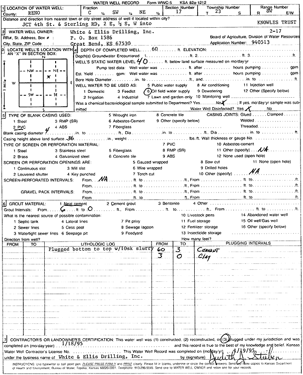
Specific Water Well Detail |
|
|
| Location Info | |||
| Owner: White and Ellis Drilling | Status: Plugged | ||
| Location: T23S, R8W, Sec. 17, C SW NE | County: Reno | ||
| Directions: from 4th St and Sterling Rd: 2 mi E, 0.5 mi S, W into | |||
| Latitude: 38.0519115 | Longitude: -98.2224971 | Datum NAD 27 | |
| Latitude: 38.0519243 | Longitude: -98.2228383 | Datum NAD 83 | |
| Longitude and latitude calculated by Survey from township-range-section-quarter calls. Only good to within the quarter call accuracy. | |||
| View well on interactive map | |||
| General Info | ||
| Well Depth: 60 ft. | Elevation: ft. | |
| Static Water Level: 40 ft. | Est. Yield: gpm. | |
| Comp. Date: 18-Jan-1995 | Well Use: Oil Field Water Supply | |
| DWR Applic. #: 940513 | Other ID: Knowles Trust 2-17 | |
| Links | |
| No Wizard information available. | |
| View info from WIMAS Water Right Data base... | |
| Driller Info | ||
| Driller: White and Ellis Drilling | License #: | |
| Scanned Form | View scan |
| Casing Info | ||
|
Casing Type: PVC
Diam: 4 in. Casing height above land surface: in | ||
| Grout Info | ||
| Grout used: Neat cement | From: 0 to 6 ft
From: 0 to 0 ft From: 0 to 0 ft | |
| Source of Possible Contamination | ||
| Source: OTHER | ||
| Direction from well: | Distance: 0 ft | |