|
|
|
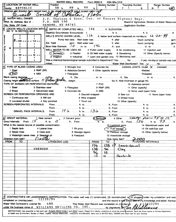
Specific Water Well Detail |
|
|
| Location Info | |||
| Owner: Theissen, J.P., and Sons | Status: Plugged | ||
| Location: T1S, R3W, Sec. 1, SW NW NW | County: Republic | ||
| Directions: from Chester, NE, 0.5 mi S | |||
| Latitude: 39.9991435 | Longitude: -97.6112273 | Datum NAD 27 | |
| Latitude: 39.9991512 | Longitude: -97.6115472 | Datum NAD 83 | |
| Longitude and latitude calculated by Survey from township-range-section-quarter calls. Only good to within the quarter call accuracy. | |||
| View well on interactive map | |||
| General Info | ||
| Well Depth: 196 ft. | Elevation: ft. | |
| Static Water Level: 138 ft. | Est. Yield: gpm. | |
| Comp. Date: 20-Dec-1994 | Well Use: Domestic | |
| DWR Applic. #: | Other ID: | |
| Driller Info | ||
| Driller: Ron Williams Drilling Co., Inc. | License #: 480 | |
| Scanned Form | View scan |
| Casing Info | ||
|
Casing Type: PVC
Diam: 0 in. Casing height above land surface: in | ||
| Grout Info | ||
| Grout used: Cement grout, Bentonite | From: 0 to 15 ft
From: 93 to 136 ft From: 0 to 0 ft | |
| Source of Possible Contamination | ||
| Source: Fuel storage | ||
| Direction from well: N | Distance: 999 ft | |