|
|
|
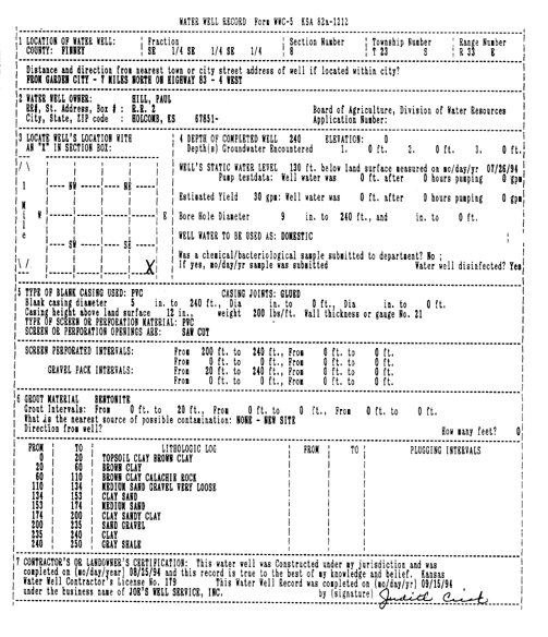
Specific Water Well Detail |
|
|
| Location Info | |||
| Owner: Hill, Paul | Status: Constructed | ||
| Location: T23S, R33W, Sec. 8, SE SE SE | County: Finney | ||
| Directions: from Garden City: 7 mi N on Hwy 83, 4 W | |||
| Latitude: 38.0626966 | Longitude: -100.9575091 | Datum NAD 27 | |
| Latitude: 38.0627202 | Longitude: -100.9579502 | Datum NAD 83 | |
| Longitude and latitude calculated by Survey from township-range-section-quarter calls. Only good to within the quarter call accuracy. | |||
| View well on interactive map | |||
| General Info | ||
| Well Depth: 240 ft. | Elevation: ft. | |
| Static Water Level: 130 ft. | Est. Yield: 30 gpm. | |
| Comp. Date: 25-Aug-1994 | Well Use: Domestic | |
| DWR Applic. #: | Other ID: | |
| Driller Info | ||
| Driller: Joe's Well Service, Inc. | License #: 179 | |
| Scanned Form | View scan |
|
Chemical Sample Submitted?: No
Water Well disinfected?: | ||
| Ground water encountered: 0 ft. , 0 ft. , 0 ft. | ||
| Pump test data: Well water was 0 ft after 0 hours pumping 0 gpm | ||
| Casing Info | ||
| Casing Type: PVC
Casing Joints: |
Diam: 5 in. to 240 ft
Diam: 0 in. to 0 ft Diam: 0 in. to 0 ft | |
| Casing height above land surface: in
Casing Weight: lbs/ft Wall thickness or gauge no.: | ||
| Screen and Perforation Info | ||
| Screen Type: PVC | Screen Openings: Saw cut | |
| Screen-perforated intervals | From: 200 ft to 240 ft
From: 0 ft to 0 ft From: 0 ft to 0 ft | |
| Gravel pack intervals | From: ft to ft | |
| Grout Info | ||
| Grout used: Bentonite | From: 0 to 20 ft
From: 0 to 0 ft From: 0 to 0 ft | |
| Source of Possible Contamination | ||
| Source: OTHER | ||
| Direction from well: | Distance: 0 ft | |
| Lithologic Log
(Log data entered by KGS.) | ||
| From: 0 ft. to 20 ft. | topsoil clay brown clay | |
| From: 20 ft. to 60 ft. | brown clay | |
| From: 60 ft. to 110 ft. | brown clay caliche rock | |
| From: 110 ft. to 134 ft. | medium sand gravel very loose | |
| From: 134 ft. to 153 ft. | clay sand | |
| From: 153 ft. to 174 ft. | medium sand | |
| From: 174 ft. to 200 ft. | clay sandy clay | |
| From: 200 ft. to 235 ft. | sand gravel | |
| From: 235 ft. to 240 ft. | clay | |
| From: 240 ft. to 250 ft. | gray shale | |