|
|
|
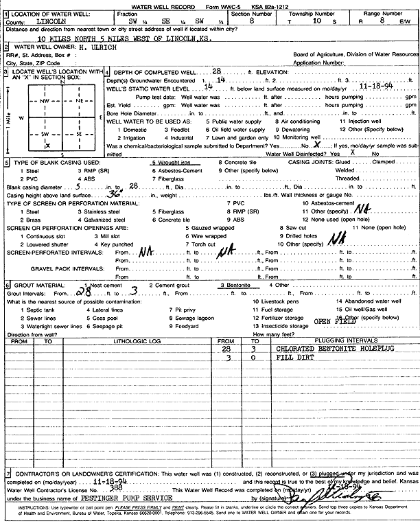
Specific Water Well Detail |
|
|
| Location Info | |||
| Owner: Ulrich, H. | Status: Plugged | ||
| Location: T10S, R8W, Sec. 8, SW SE SW | County: Lincoln | ||
| Directions: from Lincoln, 10 mi N and 5 mi W | |||
| Latitude: 39.1913603 | Longitude: -98.2407634 | Datum NAD 27 | |
| Latitude: 39.1913674 | Longitude: -98.241096 | Datum NAD 83 | |
| Longitude and latitude calculated by Survey from township-range-section-quarter calls. Only good to within the quarter call accuracy. | |||
| View well on interactive map | |||
| General Info | ||
| Well Depth: 28 ft. | Elevation: ft. | |
| Static Water Level: 14 ft. | Est. Yield: gpm. | |
| Comp. Date: 18-Nov-1994 | Well Use: (unstated)/abandoned | |
| DWR Applic. #: | Other ID: | |
| Driller Info | ||
| Driller: Paul Pestinger Pump & Water Well Drlg., Inc. | License #: 388 | |
| Scanned Form | View scan |
| Casing Info | ||
|
Casing Type: WROUGHT IRON
Diam: 5 in. Casing height above land surface: in | ||
| Grout Info | ||
| Grout used: Bentonite | From: 3 to 28 ft
From: 0 to 0 ft From: 0 to 0 ft | |
| Source of Possible Contamination | ||
| Source: OTHER | ||
| Direction from well: | Distance: 0 ft | |