|
|
|
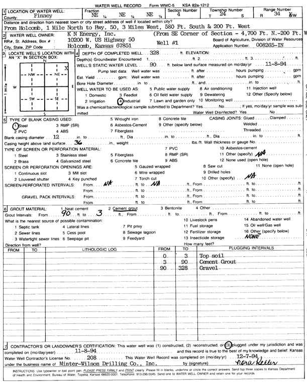
Specific Water Well Detail |
|
|
| Location Info | |||
| Owner: K.N. Energy, Inc. | Status: Plugged | ||
| Location: T24S, R34W, Sec. 4, NE NE NE | County: Finney | ||
| Directions: from Holcomb: 1 mi N to Hwy 50, 3 mi W, 580 feet S, and 200 feet W | |||
| Latitude: 38.0024415 | Longitude: -101.0489865 | Datum NAD 27 | |
| Latitude: 38.002465 | Longitude: -101.0494313 | Datum NAD 83 | |
| Longitude and latitude calculated by Survey from township-range-section-quarter calls. Only good to within the quarter call accuracy. | |||
| View well on interactive map | |||
| General Info | ||
| Well Depth: 328 ft. | Elevation: ft. | |
| Static Water Level: 90 ft. | Est. Yield: gpm. | |
| Comp. Date: 08-Nov-1994 | Well Use: Industrial | |
| DWR Applic. #: 8265-IN | Other ID: | |
| Links | |
| No Wizard information available. | |
| View info from WIMAS Water Right Data base... | |
| Driller Info | ||
| Driller: MW Drilling | License #: 208 | |
| Scanned Form | View scan |
| Casing Info | ||
|
Casing Type: Steel
Diam: 12 in. Casing height above land surface: in | ||
| Grout Info | ||
| Grout used: Cement grout | From: 3 to 90 ft
From: 0 to 0 ft From: 0 to 0 ft | |
| Source of Possible Contamination | ||
| Source: OTHER | ||
| Direction from well: | Distance: 0 ft | |