|
|
|
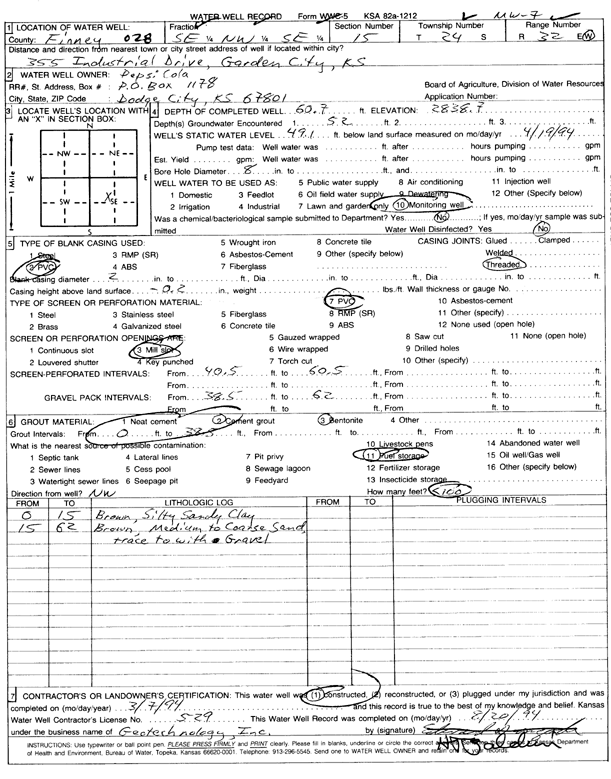
Specific Water Well Detail |
|
|
| Location Info | |||
| Owner: Pepsi Cola Bottling Co. | Status: Constructed | ||
| Location: T24S, R32W, Sec. 15, SE NW SE | County: Finney | ||
| Directions: 355 Industrial Drive, Garden City | |||
| Latitude: 37.9648318 | Longitude: -100.8158858 | Datum NAD 27 | |
| Latitude: 37.9648545 | Longitude: -100.8163233 | Datum NAD 83 | |
| Longitude and latitude calculated by Survey from township-range-section-quarter calls. Only good to within the quarter call accuracy. | |||
| View well on interactive map | |||
| General Info | ||
| Well Depth: 60.7 ft. | Elevation: 2838.7 ft. | |
| Static Water Level: 49.1 ft. | Est. Yield: gpm. | |
| Comp. Date: 07-Mar-1994 | Well Use: Monitoring well/observation/piezometer | |
| DWR Applic. #: | Other ID: MW 7 | |
| Driller Info | ||
| Driller: Geotechnology, Inc. | License #: 529 | |
| Scanned Form | View scan |
|
Chemical Sample Submitted?: No
Water Well disinfected?: | ||
| Ground water encountered: 52 ft. , 0 ft. , 0 ft. | ||
| Pump test data: Well water was 0 ft after 0 hours pumping 0 gpm | ||
| Casing Info | ||
| Casing Type: PVC
Casing Joints: |
Diam: 2 in. to 0 ft
Diam: 0 in. to 0 ft Diam: 0 in. to 0 ft | |
| Casing height above land surface: in
Casing Weight: lbs/ft Wall thickness or gauge no.: | ||
| Screen and Perforation Info | ||
| Screen Type: PVC | Screen Openings: Mill slot | |
| Screen-perforated intervals | From: 40.5 ft to 60.5 ft
From: 0 ft to 0 ft From: 0 ft to 0 ft | |
| Gravel pack intervals | From: ft to ft | |
| Grout Info | ||
| Grout used: Cement grout, Bentonite | From: 0 to 38.5 ft
From: 0 to 0 ft From: 0 to 0 ft | |
| Source of Possible Contamination | ||
| Source: Fuel storage | ||
| Direction from well: NW | Distance: 100 ft | |
| Lithologic Log
(Log data entered by KGS.) | ||
| From: 0 ft. to 15 ft. | brown, silty sandy clay | |
| From: 15 ft. to 62 ft. | brown, medium to coarse sand, trace to with gravel | |