|
|
|
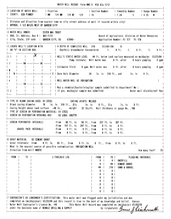
Specific Water Well Detail |
|
|
| Location Info | |||
| Owner: Ester Mai Trust | Status: Plugged | ||
| Location: T24S, R33W, Sec. 15, NW NW NE | County: Finney | ||
| Directions: from Garden City, 1.5 mi W | |||
| Latitude: 37.9739445 | Longitude: -100.9276397 | Datum NAD 27 | |
| Latitude: 37.9739681 | Longitude: -100.9280815 | Datum NAD 83 | |
| Longitude and latitude calculated by Survey from township-range-section-quarter calls. Only good to within the quarter call accuracy. | |||
| View well on interactive map | |||
| General Info | ||
| Well Depth: 310 ft. | Elevation: ft. | |
| Static Water Level: 44 ft. | Est. Yield: gpm. | |
| Comp. Date: 23-Dec-1994 | Well Use: Irrigation | |
| DWR Applic. #: FI 177 | Other ID: | |
| Links | |
| View info from Wizard Water Level Data base... | |
| View info from WIMAS Water Right Data base... | |
| Driller Info | ||
| Driller: Hydro Res. Mid Continent #145 | License #: 145 | |
| Scanned Form | View scan |
| Casing Info | ||
|
Casing Type: Steel
Diam: 16 in. Casing height above land surface: in | ||
| Grout Info | ||
| Grout used: Cement grout | From: 4 to 45 ft
From: 0 to 0 ft From: 0 to 0 ft | |
| Source of Possible Contamination | ||
| Source: OTHER | ||
| Direction from well: N | Distance: 75 ft | |