|
|
|
Specific Water Well Detail |
|
|
| Location Info | |||
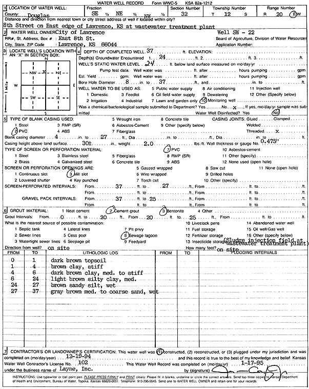
| Owner: City of Lawrence | Status: Constructed | ||
| Location: T12S, R20E, Sec. 32, SE NE NW | County: Douglas | ||
| Directions: Lawrence Wastewater Plant, 8th St on E edge of Lawrence | |||
| Latitude: 38.9688417 | Longitude: -95.21525 | Datum NAD 27 | |
| Latitude: 38.9688441 | Longitude: -95.2154997 | Datum NAD 83 | |
| Longitude and latitude calculated by Survey from township-range-section-quarter calls. Only good to within the quarter call accuracy. | |||
| View well on interactive map | |||
| General Info | ||
| Well Depth: 37 ft. | Elevation: ft. | |
| Static Water Level: 24 ft. | Est. Yield: gpm. | |
| Comp. Date: 19-Dec-1994 | Well Use: Monitoring well/observation/piezometer | |
| DWR Applic. #: | Other ID: SW 22 | |
| Driller Info | ||
| Driller: Layne-Christensen Co. | License #: 102 | |
| Scanned Form | View scan |
|
Chemical Sample Submitted?: No
Water Well disinfected?: | ||
| Ground water encountered: 24 ft. , 0 ft. , 0 ft. | ||
| Pump test data: Well water was 0 ft after 0 hours pumping 0 gpm | ||
| Casing Info | ||
| Casing Type: PVC
Casing Joints: |
Diam: 4 in. to 27 ft
Diam: 0 in. to 0 ft Diam: 0 in. to 0 ft | |
| Casing height above land surface: in
Casing Weight: lbs/ft Wall thickness or gauge no.: | ||
| Screen and Perforation Info | ||
| Screen Type: PVC | Screen Openings: Mill slot | |
| Screen-perforated intervals | From: 27 ft to 37 ft
From: 0 ft to 0 ft From: 0 ft to 0 ft | |
| Gravel pack intervals | From: ft to ft | |
| Grout Info | ||
| Grout used: Cement grout, Bentonite | From: 0 to 20 ft
From: 20 to 25 ft From: 0 to 0 ft | |
| Source of Possible Contamination | ||
| Source: Sewage lagoon | ||
| Direction from well: | Distance: 0 ft | |
| Lithologic Log
(Log data entered by KGS.) | ||
| From: 0 ft. to 1 ft. | dark brown top soil | |
| From: 1 ft. to 4 ft. | brown clay, stiff | |
| From: 4 ft. to 6 ft. | dark brown clay, medium to stiff | |
| From: 6 ft. to 24 ft. | light brown silty clay, medium | |
| From: 24 ft. to 27 ft. | brown sandy silt, wet | |
| From: 27 ft. to 37 ft. | gray brown medium to coarse sand, wet | |