|
|
|
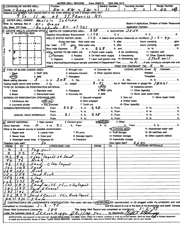
Specific Water Well Detail |
|
|
| Location Info | |||
| Owner: Schlepp, Melvin | Status: Constructed | ||
| Location: T5S, R42W, Sec. 11, NW NW SW | County: Cheyenne | ||
| Directions: from St. Francis, 9 mi S and 11 mi W | |||
| Latitude: 39.632431 | Longitude: -102.0111521 | Datum NAD 27 | |
| Latitude: 39.6324251 | Longitude: -102.0116128 | Datum NAD 83 | |
| Longitude and latitude calculated by Survey from township-range-section-quarter calls. Only good to within the quarter call accuracy. | |||
| View well on interactive map | |||
| General Info | ||
| Well Depth: 228 ft. | Elevation: 3550 ft. | |
| Static Water Level: 174 ft. | Est. Yield: 10 gpm. | |
| Comp. Date: 02-Mar-1995 | Well Use: Domestic, Livestock | |
| DWR Applic. #: | Other ID: | |
| Driller Info | ||
| Driller: Schoenrogge Drilling, Inc. | License #: 184 | |
| Scanned Form | View scan |
|
Chemical Sample Submitted?: No
Water Well disinfected?: | ||
| Ground water encountered: 174 ft. , 0 ft. , 0 ft. | ||
| Pump test data: Well water was 0 ft after 0 hours pumping 0 gpm | ||
| Casing Info | ||
| Casing Type: PVC
Casing Joints: |
Diam: 5 in. to 208 ft
Diam: 0 in. to 0 ft Diam: 0 in. to 0 ft | |
| Casing height above land surface: in
Casing Weight: lbs/ft Wall thickness or gauge no.: | ||
| Screen and Perforation Info | ||
| Screen Type: PVC | Screen Openings: Mill slot | |
| Screen-perforated intervals | From: 208 ft to 228 ft
From: 0 ft to 0 ft From: 0 ft to 0 ft | |
| Gravel pack intervals | From: ft to ft | |
| Grout Info | ||
| Grout used: Bentonite | From: 0 to 21 ft
From: 0 to 0 ft From: 0 to 0 ft | |
| Source of Possible Contamination | ||
| Source: Livestock pens | ||
| Direction from well: S | Distance: 999 ft | |
| Lithologic Log
(Log data entered by KGS.) | ||
| From: 0 ft. to 2 ft. | Topsoil | |
| From: 2 ft. to 72 ft. | Clay | |
| From: 72 ft. to 94 ft. | Clay layers of sand | |
| From: 94 ft. to 96 ft. | Rock | |
| From: 96 ft. to 143 ft. | Sand, clay layers | |
| From: 143 ft. to 149 ft. | Sand | |
| From: 149 ft. to 150 ft. | Rock | |
| From: 150 ft. to 159 ft. | Sand rock | |
| From: 159 ft. to 172 ft. | Clay | |
| From: 172 ft. to 173 ft. | Rock | |
| From: 173 ft. to 187 ft. | Sand with thin clay layers | |
| From: 187 ft. to 195 ft. | Sand and gravel | |
| From: 195 ft. to 196 ft. | Rock | |
| From: 196 ft. to 227 ft. | Sand and gravel, thin rock layers | |
| From: 227 ft. to 230 ft. | Shale | |