|
|
|
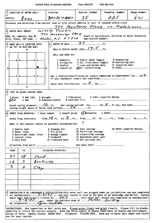
Specific Water Well Detail |
|
|
| Location Info | |||
| Owner: Wesley Towers | Status: Plugged | ||
| Location: T22S, R6W, Sec. 35, SW SE NE | County: Reno | ||
| Directions: 700 Monterey Pl, Hutchinson | |||
| Latitude: 38.0941208 | Longitude: -97.9438912 | Datum NAD 27 | |
| Latitude: 38.0941318 | Longitude: -97.9442213 | Datum NAD 83 | |
| Longitude and latitude calculated by Survey from township-range-section-quarter calls. Only good to within the quarter call accuracy. | |||
| View well on interactive map | |||
| General Info | ||
| Well Depth: 47 ft. | Elevation: ft. | |
| Static Water Level: 17.5 ft. | Est. Yield: gpm. | |
| Comp. Date: 31-Mar-1995 | Well Use: Air Conditioning | |
| DWR Applic. #: | Other ID: | |
| Driller Info | ||
| Driller: Miller Drilling | License #: 447 | |
| Scanned Form | View scan |
| Casing Info | ||
|
Casing Type: PVC
Diam: 10 in. Casing height above land surface: in | ||
| Grout Info | ||
| Grout used: Bentonite | From: 3 to 18 ft
From: 0 to 0 ft From: 0 to 0 ft | |
| Source of Possible Contamination | ||
| Source: OTHER | ||
| Direction from well: | Distance: 0 ft | |