|
|
|
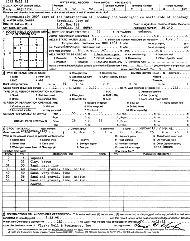
Specific Water Well Detail |
|
|
| Location Info | |||
| Owner: City of Republic | Status: Constructed | ||
| Location: T1S, R4W, Sec. 31, NW SW NW | County: Republic | ||
| Directions: from Broadway and Washington, 300 feet E on north side of Broadway | |||
| Latitude: 39.9247731 | Longitude: -97.8181379 | Datum NAD 27 | |
| Latitude: 39.9247834 | Longitude: -97.8184587 | Datum NAD 83 | |
| Longitude and latitude calculated by Survey from township-range-section-quarter calls. Only good to within the quarter call accuracy. | |||
| View well on interactive map | |||
| General Info | ||
| Well Depth: 63 ft. | Elevation: ft. | |
| Static Water Level: 41 ft. | Est. Yield: gpm. | |
| Comp. Date: 22-Mar-1995 | Well Use: Public Water Supply | |
| DWR Applic. #: 30240 | Other ID: Well 3 | |
| Links | |
| No Wizard information available. | |
| View info from WIMAS Water Right Data base... | |
| Driller Info | ||
| Driller: Clarke Well and Equipment, Inc. | License #: 185 | |
| Scanned Form | View scan |
|
Chemical Sample Submitted?: No
Water Well disinfected?: | ||
| Ground water encountered: 0 ft. , 0 ft. , 0 ft. | ||
| Pump test data: Well water was 0 ft after 0 hours pumping 0 gpm | ||
| Casing Info | ||
| Casing Type: PVC
Casing Joints: |
Diam: 6 in. to 55 ft
Diam: 0 in. to 0 ft Diam: 0 in. to 0 ft | |
| Casing height above land surface: in
Casing Weight: lbs/ft Wall thickness or gauge no.: | ||
| Screen and Perforation Info | ||
| Screen Type: Stainless Steel | Screen Openings: Continuous slot | |
| Screen-perforated intervals | From: 55 ft to 62 ft
From: 0 ft to 0 ft From: 0 ft to 0 ft | |
| Gravel pack intervals | From: ft to ft | |
| Grout Info | ||
| Grout used: Cement grout, | From: 0 to 5 ft
From: 5 to 25 ft From: 25 to 26 ft | |
| Source of Possible Contamination | ||
| Source: OTHER | ||
| Direction from well: | Distance: 0 ft | |
| Lithologic Log
(Log data entered by KGS.) | ||
| From: 0 ft. to 4 ft. | top soil | |
| From: 4 ft. to 31 ft. | clay, brown | |
| From: 31 ft. to 33 ft. | sand, very fine | |
| From: 33 ft. to 40 ft. | sand and gravel, fine, medium | |
| From: 40 ft. to 50 ft. | sand, very fine, fine | |
| From: 50 ft. to 56 ft. | sand and gravel, fine, medium | |
| From: 56 ft. to 62 ft. | sand and gravel, fine, medium, coarse | |