|
|
|
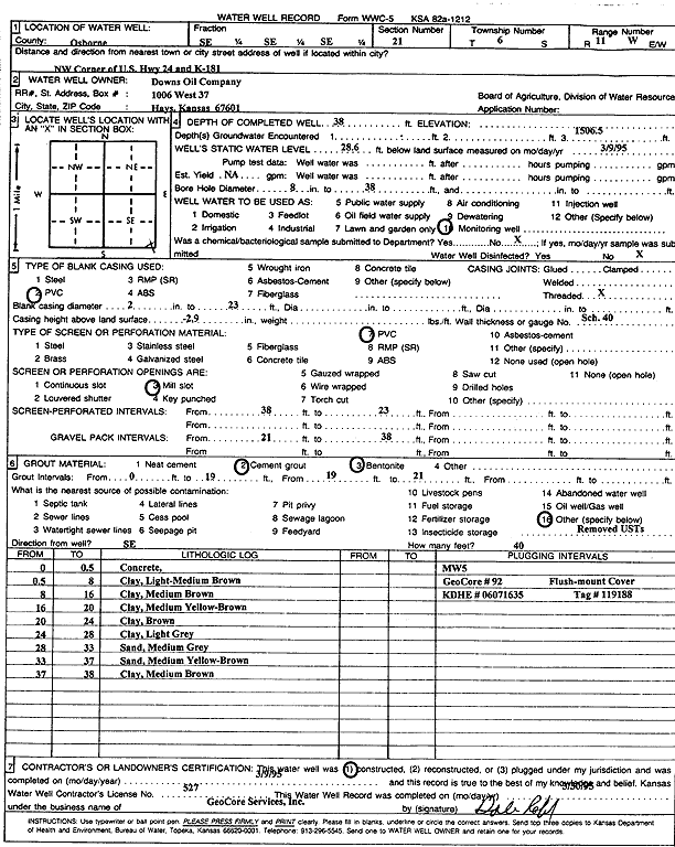
Specific Water Well Detail |
|
|
| Location Info | |||
| Owner: Downs Oil Co. | Status: Constructed | ||
| Location: T6S, R11W, Sec. 21, SE SE SE | County: Osborne | ||
| Directions: US Hwy 24 and K-181, NW corner | |||
| Latitude: 39.5102067 | Longitude: -98.5451504 | Datum NAD 27 | |
| Latitude: 39.5102173 | Longitude: -98.5454937 | Datum NAD 83 | |
| Longitude and latitude calculated by Survey from township-range-section-quarter calls. Only good to within the quarter call accuracy. | |||
| View well on interactive map | |||
| General Info | ||
| Well Depth: 38 ft. | Elevation: ft. | |
| Static Water Level: 28.6 ft. | Est. Yield: gpm. | |
| Comp. Date: 09-Mar-1995 | Well Use: Monitoring well/observation/piezometer | |
| DWR Applic. #: | Other ID: MW 5 | |
| Driller Info | ||
| Driller: GeoCore Services Inc. | License #: 527 | |
| Scanned Form | View scan |
|
Chemical Sample Submitted?: No
Water Well disinfected?: | ||
| Ground water encountered: 0 ft. , 0 ft. , 1506.5 ft. | ||
| Pump test data: Well water was 0 ft after 0 hours pumping 0 gpm | ||
| Casing Info | ||
| Casing Type: PVC
Casing Joints: |
Diam: 2 in. to 23 ft
Diam: 0 in. to 0 ft Diam: 0 in. to 0 ft | |
| Casing height above land surface: in
Casing Weight: lbs/ft Wall thickness or gauge no.: | ||
| Screen and Perforation Info | ||
| Screen Type: PVC | Screen Openings: Mill slot | |
| Screen-perforated intervals | From: 23 ft to 38 ft
From: 0 ft to 0 ft From: 0 ft to 0 ft | |
| Gravel pack intervals | From: ft to ft | |
| Grout Info | ||
| Grout used: Cement grout, Bentonite | From: 0 to 19 ft
From: 19 to 21 ft From: 0 to 0 ft | |
| Source of Possible Contamination | ||
| Source: OTHER | ||
| Direction from well: SE | Distance: 40 ft | |
| Lithologic Log
(Log data entered by KGS.) | ||
| From: 0 ft. to .5 ft. | concrete | |
| From: .5 ft. to 8 ft. | clay, light-medium brown | |
| From: 8 ft. to 16 ft. | clay, medium brown | |
| From: 16 ft. to 20 ft. | clay, medium yellow-brown | |
| From: 20 ft. to 24 ft. | clay, brown | |
| From: 24 ft. to 28 ft. | clay, light gray | |
| From: 28 ft. to 33 ft. | sand, medium gray | |
| From: 33 ft. to 37 ft. | sand, medium yellow-brown | |
| From: 37 ft. to 38 ft. | clay, medium brown | |