|
|
|
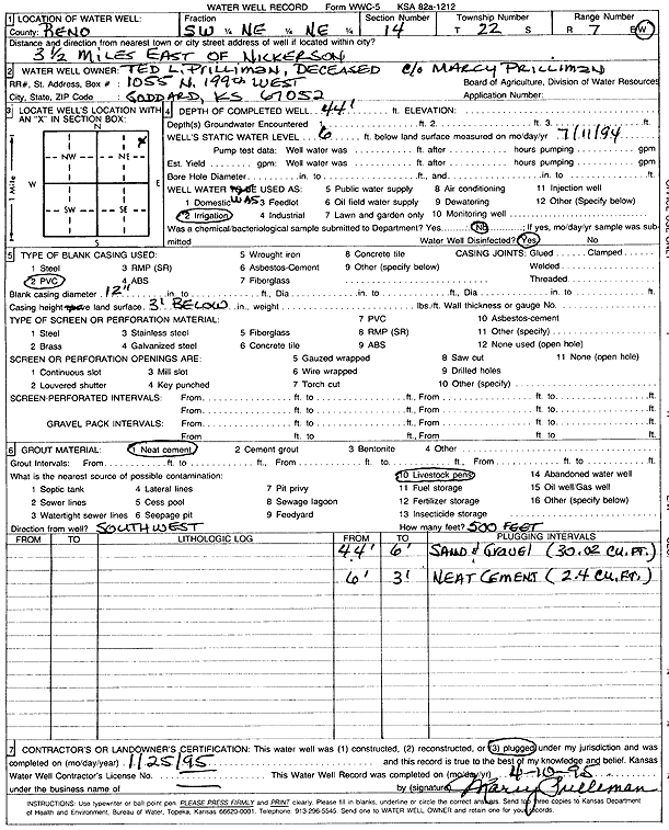
Specific Water Well Detail |
|
|
| Location Info | |||
| Owner: Prilliman, Ted L. | Status: Plugged | ||
| Location: T22S, R7W, Sec. 14, SW NE NE | County: Reno | ||
| Directions: from Nickerson: 3.5 mi E | |||
| Latitude: 38.1419478 | Longitude: -98.0535718 | Datum NAD 27 | |
| Latitude: 38.1419589 | Longitude: -98.0539052 | Datum NAD 83 | |
| Longitude and latitude calculated by Survey from township-range-section-quarter calls. Only good to within the quarter call accuracy. | |||
| View well on interactive map | |||
| General Info | ||
| Well Depth: 44 ft. | Elevation: ft. | |
| Static Water Level: 6 ft. | Est. Yield: gpm. | |
| Comp. Date: 25-Jan-1995 | Well Use: Irrigation | |
| DWR Applic. #: | Other ID: | |
| Links | |
| No Wizard information available. | |
| View info from WIMAS Water Right Data base... | |
| Driller Info | ||
| Driller: Mary Prilliman | License #: | |
| Scanned Form | View scan |
| Casing Info | ||
|
Casing Type: PVC
Diam: 12 in. Casing height above land surface: in | ||
| Grout Info | ||
| Grout used: Neat cement | From: 3 to 6 ft
From: 0 to 0 ft From: 0 to 0 ft | |
| Source of Possible Contamination | ||
| Source: Livestock pens | ||
| Direction from well: SW | Distance: 500 ft | |