|
|
|
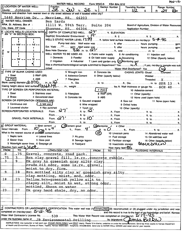
Specific Water Well Detail |
|
|
| Location Info | |||
| Owner: Zarda, Ben | Status: Constructed | ||
| Location: T12S, R24E, Sec. 1, SE SW SE | County: Johnson | ||
| Directions: 5440 Merriam Dr, Merriam | |||
| Latitude: 39.0304363 | Longitude: -94.6920758 | Datum NAD 27 | |
| Latitude: 39.0304416 | Longitude: -94.6923127 | Datum NAD 83 | |
| Longitude and latitude calculated by Survey from township-range-section-quarter calls. Only good to within the quarter call accuracy. | |||
| View well on interactive map | |||
| General Info | ||
| Well Depth: 27 ft. | Elevation: ft. | |
| Static Water Level: 17.99 ft. | Est. Yield: gpm. | |
| Comp. Date: 02-May-1995 | Well Use: Monitoring well/observation/piezometer | |
| DWR Applic. #: | Other ID: MW 12 | |
| Driller Info | ||
| Driller: JB Environmental Drilling | License #: 539 | |
| Scanned Form | View scan |
|
Chemical Sample Submitted?: No
Water Well disinfected?: | ||
| Ground water encountered: 1900 ft. , 0 ft. , 0 ft. | ||
| Pump test data: Well water was 0 ft after 0 hours pumping 0 gpm | ||
| Casing Info | ||
| Casing Type: PVC
Casing Joints: |
Diam: 2.4 in. to 12 ft
Diam: 0 in. to 0 ft Diam: 0 in. to 0 ft | |
| Casing height above land surface: in
Casing Weight: lbs/ft Wall thickness or gauge no.: | ||
| Screen and Perforation Info | ||
| Screen Type: PVC | Screen Openings: Mill slot | |
| Screen-perforated intervals | From: 12 ft to 27 ft
From: 0 ft to 0 ft From: 0 ft to 0 ft | |
| Gravel pack intervals | From: ft to ft | |
| Grout Info | ||
| Grout used: Cement grout, Bentonite | From: 0 to 4 ft
From: 4 to 10 ft From: 0 to 0 ft | |
| Source of Possible Contamination | ||
| Source: OTHER | ||
| Direction from well: W | Distance: 85 ft | |
| Lithologic Log
(Log data entered by KGS.) | ||
| From: 0 ft. to .8 ft. | gravel, concrete, rock pack | |
| From: .8 ft. to 3 ft. | brown clay, gravel fill, limestone rock, concrete rubble | |
| From: 3 ft. to 9 ft. | dark gray to greenish gray silty clay, crude oil odor, some limestone rock gravel, moist to dry, firm | |
| From: 9 ft. to 18 ft. | brown mottled silty clay with greenish gray silty clay mottling, moist, moderate odor | |
| From: 18 ft. to 23 ft. | yellow brown-greenish yellow silt to clayey silt, moist to wet, strong odor, mottled, sheen on water | |
| From: 23 ft. to 27 ft. | dark gray hard shale, dry, no odor | |