|
|
|
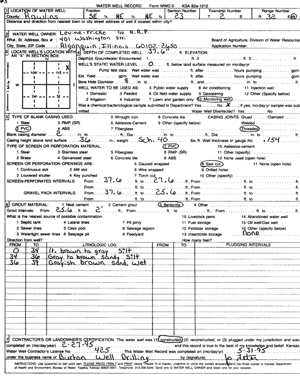
Specific Water Well Detail |
|
|
| Location Info | |||
| Owner: Levine-Fricke | Status: Constructed | ||
| Location: T2S, R32W, Sec. 23, SE NE NE | County: Rawlins | ||
| Directions: | |||
| Latitude: 39.8692894 | Longitude: -100.871208 | Datum NAD 27 | |
| Latitude: 39.8692924 | Longitude: -100.8716397 | Datum NAD 83 | |
| Longitude and latitude calculated by Survey from township-range-section-quarter calls. Only good to within the quarter call accuracy. | |||
| View well on interactive map | |||
| General Info | ||
| Well Depth: 37.6 ft. | Elevation: ft. | |
| Static Water Level: ft. | Est. Yield: gpm. | |
| Comp. Date: 27-Feb-1995 | Well Use: Monitoring well/observation/piezometer | |
| DWR Applic. #: | Other ID: | |
| Driller Info | ||
| Driller: Burton Well Drilling, Inc. | License #: 425 | |
| Scanned Form | View scan |
|
Chemical Sample Submitted?: No
Water Well disinfected?: | ||
| Ground water encountered: 0 ft. , 0 ft. , 0 ft. | ||
| Pump test data: Well water was 0 ft after 0 hours pumping 0 gpm | ||
| Casing Info | ||
| Casing Type: PVC
Casing Joints: |
Diam: 2 in. to 0 ft
Diam: 0 in. to 0 ft Diam: 0 in. to 0 ft | |
| Casing height above land surface: in
Casing Weight: lbs/ft Wall thickness or gauge no.: | ||
| Screen and Perforation Info | ||
| Screen Type: PVC | Screen Openings: Saw cut | |
| Screen-perforated intervals | From: 27.6 ft to 37.6 ft
From: 0 ft to 0 ft From: 0 ft to 0 ft | |
| Gravel pack intervals | From: ft to ft | |
| Grout Info | ||
| Grout used: Bentonite | From: 2 to 25.6 ft
From: 0 to 0 ft From: 0 to 0 ft | |
| Source of Possible Contamination | ||
| Source: OTHER | ||
| Direction from well: | Distance: 0 ft | |
| Lithologic Log
(Log data entered by KGS.) | ||
| From: 0 ft. to 34 ft. | light brown to gray silt | |
| From: 34 ft. to 36 ft. | gray to brown sandy silt | |
| From: 36 ft. to 39 ft. | grayish brown sand, wet | |