|
|
|
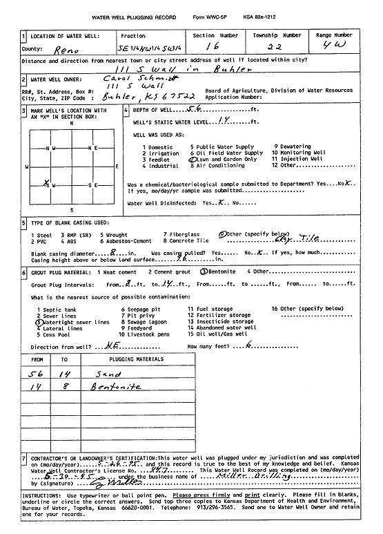
Specific Water Well Detail |
|
|
| Location Info | |||
| Owner: Schmidt, Carol | Status: Plugged | ||
| Location: T22S, R4W, Sec. 16, SE NW SW | County: Reno | ||
| Directions: 111 S Wall, Buhler | |||
| Latitude: 38.1347667 | Longitude: -97.7720616 | Datum NAD 27 | |
| Latitude: 38.134777 | Longitude: -97.7723872 | Datum NAD 83 | |
| Longitude and latitude calculated by Survey from township-range-section-quarter calls. Only good to within the quarter call accuracy. | |||
| View well on interactive map | |||
| General Info | ||
| Well Depth: 56 ft. | Elevation: ft. | |
| Static Water Level: 14 ft. | Est. Yield: gpm. | |
| Comp. Date: 26-May-1995 | Well Use: Domestic, Lawn and Garden | |
| DWR Applic. #: | Other ID: | |
| Driller Info | ||
| Driller: Miller Drilling | License #: 447 | |
| Scanned Form | View scan |
| Casing Info | ||
|
Casing Type: OTHER
Diam: 8 in. Casing height above land surface: in | ||
| Grout Info | ||
| Grout used: Bentonite | From: 8 to 14 ft
From: 0 to 0 ft From: 0 to 0 ft | |
| Source of Possible Contamination | ||
| Source: Watertight sewer lines | ||
| Direction from well: NE | Distance: 6 ft | |