|
|
|
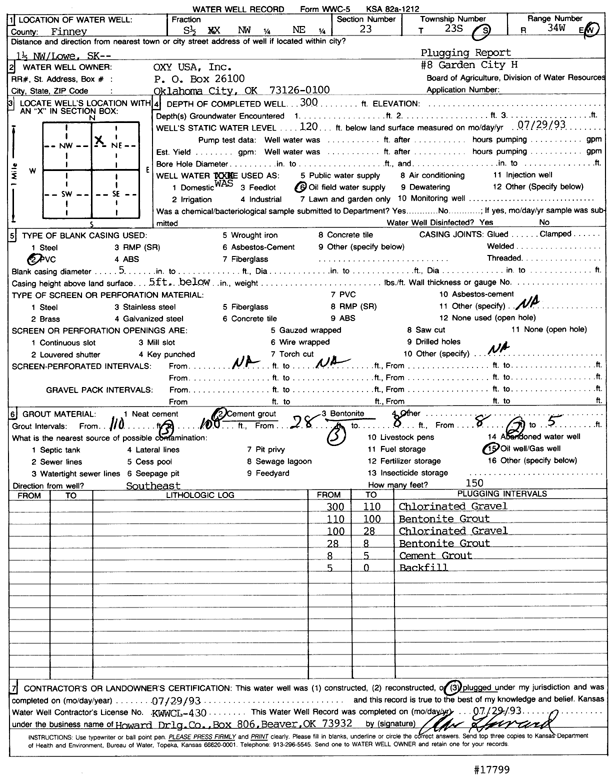
Specific Water Well Detail |
|
|
| Location Info | |||
| Owner: Oxy USA, Inc. | Status: Plugged | ||
| Location: T23S, R34W, Sec. 23, S2 NW NE | County: Finney | ||
| Directions: from Lowe, 1.5 mi MW | |||
| Latitude: 38.0442901 | Longitude: -101.0174191 | Datum NAD 27 | |
| Latitude: 38.044314 | Longitude: -101.0178626 | Datum NAD 83 | |
| Longitude and latitude calculated by Survey from township-range-section-quarter calls. Only good to within the quarter call accuracy. | |||
| View well on interactive map | |||
| General Info | ||
| Well Depth: 300 ft. | Elevation: ft. | |
| Static Water Level: 120 ft. | Est. Yield: gpm. | |
| Comp. Date: 29-Jul-1993 | Well Use: Oil Field Water Supply | |
| DWR Applic. #: | Other ID: Garden City H 8 | |
| Links | |
| No Wizard information available. | |
| View info from WIMAS Water Right Data base... | |
| Driller Info | ||
| Driller: Howard Drilling Co. | License #: 430 | |
| Scanned Form | View scan |
| Casing Info | ||
|
Casing Type: PVC
Diam: 5 in. Casing height above land surface: in | ||
| Grout Info | ||
| Grout used: Cement grout, Bentonite | From: 5 to 8 ft
From: 8 to 28 ft From: 100 to 110 ft | |
| Source of Possible Contamination | ||
| Source: Oil well/gas well | ||
| Direction from well: SE | Distance: 150 ft | |