|
|
|
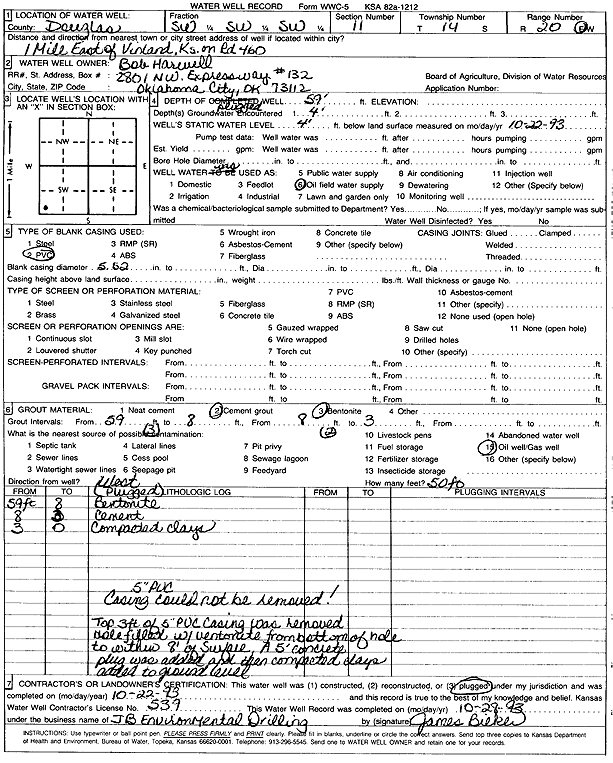
Specific Water Well Detail |
|
|
| Location Info | |||
| Owner: Harwell, Bob | Status: Plugged | ||
| Location: T14S, R20E, Sec. 11, SW SW SW | County: Douglas | ||
| Directions: from Vinland: 1 mi E on Rd 460 | |||
| Latitude: 38.8415346 | Longitude: -95.1662581 | Datum NAD 27 | |
| Latitude: 38.8415403 | Longitude: -95.1665069 | Datum NAD 83 | |
| Longitude and latitude calculated by Survey from township-range-section-quarter calls. Only good to within the quarter call accuracy. | |||
| View well on interactive map | |||
| General Info | ||
| Well Depth: 59 ft. | Elevation: ft. | |
| Static Water Level: 4 ft. | Est. Yield: gpm. | |
| Comp. Date: 22-Oct-1993 | Well Use: Oil Field Water Supply | |
| DWR Applic. #: | Other ID: | |
| Links | |
| No Wizard information available. | |
| View info from WIMAS Water Right Data base... | |
| Driller Info | ||
| Driller: JB Environmental Drilling | License #: 539 | |
| Scanned Form | View scan |
| Casing Info | ||
|
Casing Type: PVC
Diam: 5.5 in. Casing height above land surface: in | ||
| Grout Info | ||
| Grout used: Cement grout, Bentonite | From: 3 to 8 ft
From: 8 to 59 ft From: 0 to 0 ft | |
| Source of Possible Contamination | ||
| Source: Oil well/gas well | ||
| Direction from well: W | Distance: 50 ft | |