|
|
|
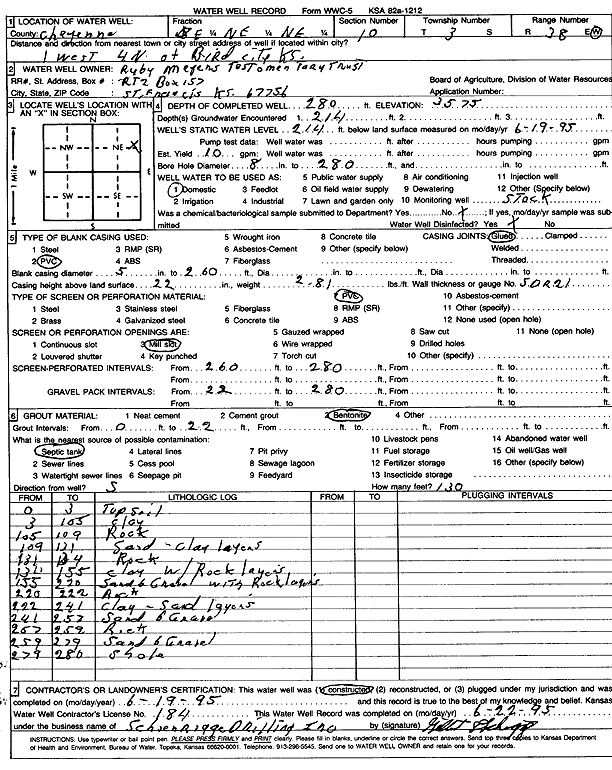
Specific Water Well Detail |
|
|
| Location Info | |||
| Owner: Ruby Meyers Trust | Status: Constructed | ||
| Location: T3S, R38W, Sec. 10, SE NE NE | County: Cheyenne | ||
| Directions: from Bird City, 1 mi W and 4 mi N | |||
| Latitude: 39.8122644 | Longitude: -101.5610599 | Datum NAD 27 | |
| Latitude: 39.8122593 | Longitude: -101.5615047 | Datum NAD 83 | |
| Longitude and latitude calculated by Survey from township-range-section-quarter calls. Only good to within the quarter call accuracy. | |||
| View well on interactive map | |||
| General Info | ||
| Well Depth: 280 ft. | Elevation: 3575 ft. | |
| Static Water Level: 214 ft. | Est. Yield: 10 gpm. | |
| Comp. Date: 19-Jun-1995 | Well Use: Domestic, Livestock | |
| DWR Applic. #: | Other ID: | |
| Driller Info | ||
| Driller: Schoenrogge Drilling, Inc. | License #: 184 | |
| Scanned Form | View scan |
|
Chemical Sample Submitted?: No
Water Well disinfected?: | ||
| Ground water encountered: 2.14 ft. , 0 ft. , 0 ft. | ||
| Pump test data: Well water was 0 ft after 0 hours pumping 0 gpm | ||
| Casing Info | ||
| Casing Type: PVC
Casing Joints: |
Diam: 5 in. to 260 ft
Diam: 0 in. to 0 ft Diam: 0 in. to 0 ft | |
| Casing height above land surface: in
Casing Weight: lbs/ft Wall thickness or gauge no.: | ||
| Screen and Perforation Info | ||
| Screen Type: PVC | Screen Openings: Mill slot | |
| Screen-perforated intervals | From: 260 ft to 280 ft
From: 0 ft to 0 ft From: 0 ft to 0 ft | |
| Gravel pack intervals | From: ft to ft | |
| Grout Info | ||
| Grout used: Bentonite | From: 0 to 22 ft
From: 0 to 0 ft From: 0 to 0 ft | |
| Source of Possible Contamination | ||
| Source: Septic Tank | ||
| Direction from well: S | Distance: 130 ft | |
| Lithologic Log
(Log data entered by KGS.) | ||
| From: 0 ft. to 3 ft. | Topsoil | |
| From: 3 ft. to 105 ft. | Clay | |
| From: 105 ft. to 109 ft. | Rock | |
| From: 109 ft. to 131 ft. | Sand, clay layers | |
| From: 131 ft. to 134 ft. | Rock | |
| From: 134 ft. to 155 ft. | Clay with rock layers | |
| From: 155 ft. to 220 ft. | Sand and gravel with rock layers | |
| From: 220 ft. to 222 ft. | Rock | |
| From: 222 ft. to 241 ft. | Clay, sand layers | |
| From: 241 ft. to 257 ft. | Sand and gravel | |
| From: 257 ft. to 259 ft. | Rock | |
| From: 259 ft. to 279 ft. | Sand and gravel | |
| From: 279 ft. to 280 ft. | Shale | |