Select location of well to view details.
Click on column heading to sort.
|
|
|
County: Rooks Select location of well to view details. Click on column heading to sort. |
|
|
|
| View page: 1 || 2 || 3 || 4 || 5 || 6 || 7 || 8 || 9 || 10 || Next > | |||||||||
| T-R-S | Owner | Well Depth Ascend. Desc. |
Static Water Level Ascend. Desc. |
Est. Yield Ascend. Desc. |
Well Use | Other ID | Action Taken | Completion Date Ascend. Desc. |
Scan? |
|
T6S, R17W, Sec. 1 NE NW NE |
Molzahn, Bill | 58 ft. | 14 ft. | .5 gpm. | Domestic, Livestock | Constructed | 06-Mar-2026 |
KOLAR |
|
|
T6S, R17W, Sec. 3 NW NW NW NE |
Dix, Jeff | 27 ft. | 9 ft. | 10 gpm. | Domestic, Livestock | Constructed | 22-Nov-2010 | ||
|
T6S, R17W, Sec. 5 C NW SW |
Muir, Verl | 54 ft. | 22 ft. | Domestic | Constructed | 13-Feb-2008 | |||
|
T6S, R17W, Sec. 6 SE SE SE SE |
Apple, Nate | 28 ft. | 14 ft. | 8 gpm. | Domestic, Livestock | Constructed | 18-Sep-2018 |
KOLAR |
|
|
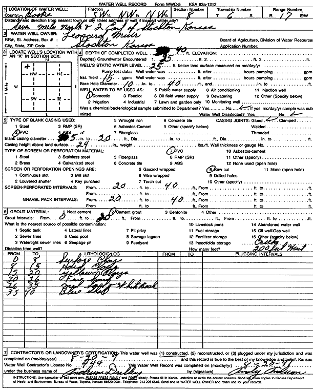
T6S, R17W, Sec. 8 SW NW NW |
Muir, Leonard | 40 ft. | 25 ft. | 15 gpm. | Domestic | Constructed | 20-Aug-1991 | Scan | |
|
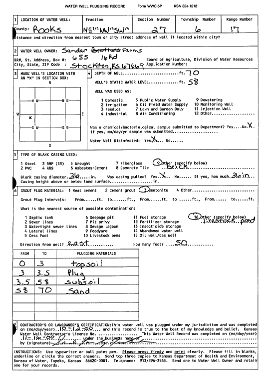
T6S, R17W, Sec. 27 NE NW SW |
Sander Farms | 70 ft. | 58 ft. | (unstated)/abandoned | Plugged | 12-Oct-2000 | Scan | ||
|
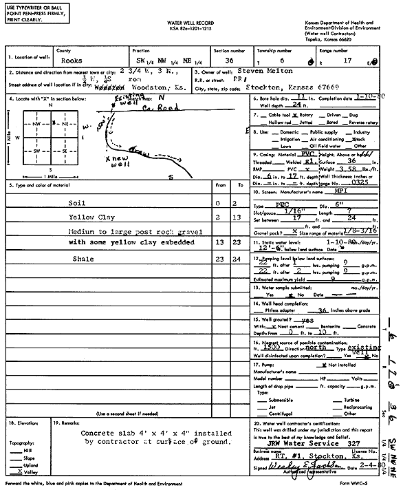
T6S, R17W, Sec. 36 SW NW NE |
Melton, Steven | 24 ft. | 12.5 ft. | 9 gpm. | Domestic, Livestock | Constructed | 10-Jan-1980 | Scan | |
|
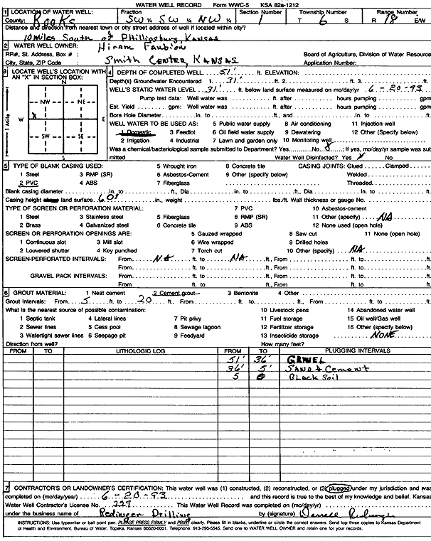
T6S, R18W, Sec. 1 SW SW NW |
Faubion, Hiram | 51 ft. | 31 ft. | Domestic | Plugged | 20-Jun-1993 | Scan | ||
|
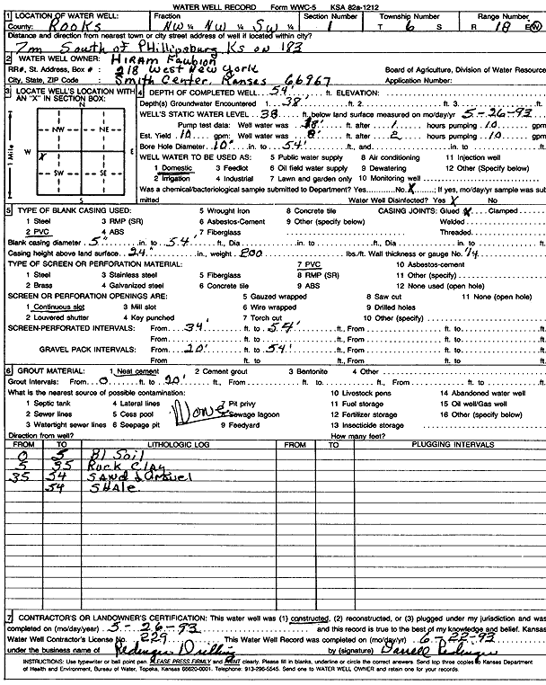
T6S, R18W, Sec. 1 NW NW SW |
Faubion, Hiram | 54 ft. | 38 ft. | 10 gpm. | Domestic | Constructed | 26-May-1993 | Scan | |
|
T6S, R18W, Sec. 1 NW NW |
Kansas Dept. of Transportation, KDOT | 40 ft. | 5.7 ft. | Test Hole, Geotechnical | 183-82 K-3835-01 | Constructed | 14-Aug-1990 | ||
|
T6S, R18W, Sec. 1 NW NW |
Kansas Dept. of Transportation, KDOT | 55 ft. | Test Hole, Geotechnical | 183-82 K-3835-01 | Constructed | 24-Oct-1989 | |||
|
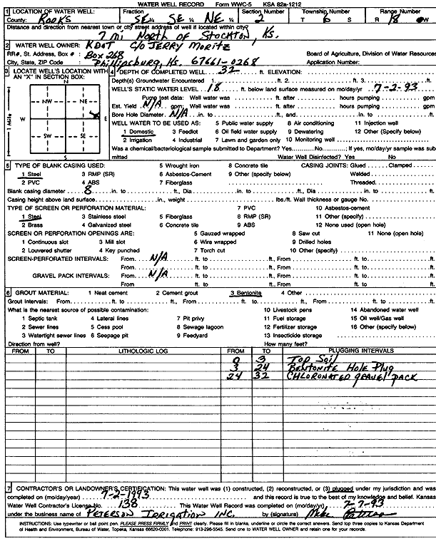
T6S, R18W, Sec. 2 SE SE NE |
Kansas Dept. of Transportation, KDOT | 32 ft. | 18 ft. | Domestic | Plugged | 02-Jul-1993 | Scan | ||
|
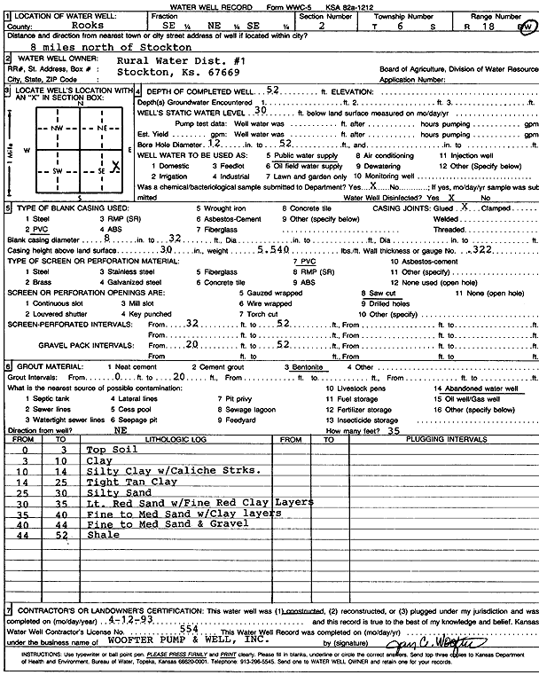
T6S, R18W, Sec. 2 SE NE SE |
Rooks Co. RWD 1 | 52 ft. | 30 ft. | Public Water Supply | Constructed | 12-Apr-1993 | Scan | ||
|
T6S, R18W, Sec. 4 NE NE SE SE |
Mongeau, Martin | 30 ft. | 13 ft. | 12 gpm. | Domestic, Livestock | Constructed | 13-Mar-2015 | ||
|
T6S, R18W, Sec. 5 SW NE SE |
McLaughlin, Don | 64 ft. | 21 ft. | Domestic | Constructed | 06-Feb-2008 | |||
|
T6S, R18W, Sec. 5 SW SE SW |
Roese, Bob | 51 ft. | 12 ft. | Domestic | Constructed | 26-Nov-2008 | |||
|
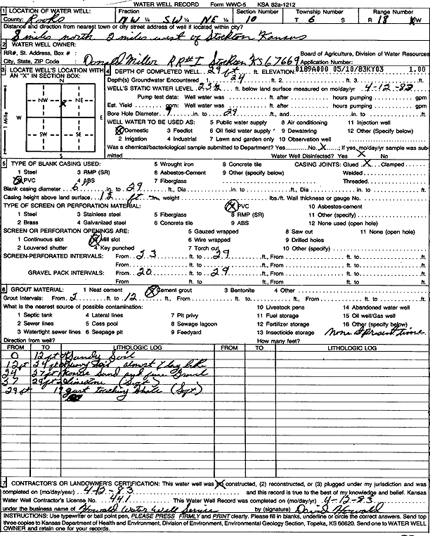
T6S, R18W, Sec. 10 NW SW NE |
Miller, Don | 29 ft. | 23.5 ft. | Domestic | Constructed | 12-Apr-1983 | Scan | ||
|
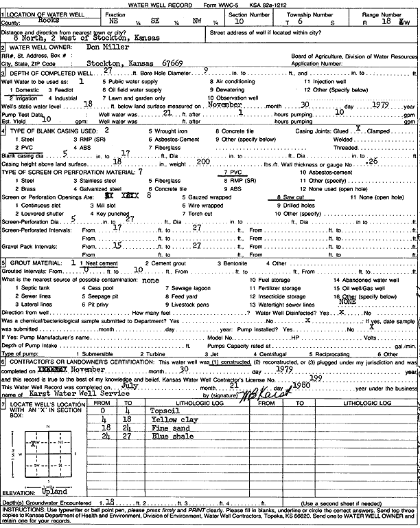
T6S, R18W, Sec. 10 NE SE NW |
Miller, Don | 27 ft. | 18 ft. | 10 gpm. | Domestic | Constructed | 30-Nov-1979 | Scan | |
|
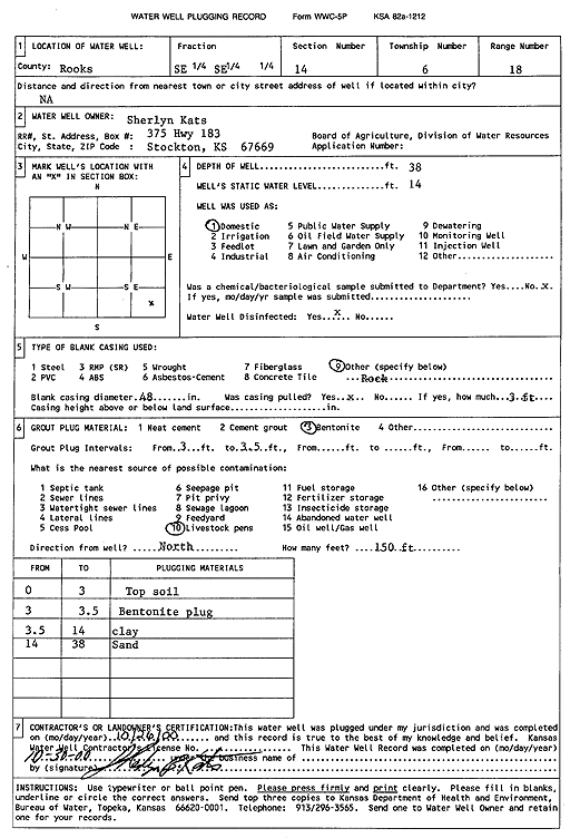
T6S, R18W, Sec. 14 SE SE |
Kats, Sherlyn | 38 ft. | 14 ft. | Domestic | Plugged | 26-Oct-2000 | Scan | ||
|
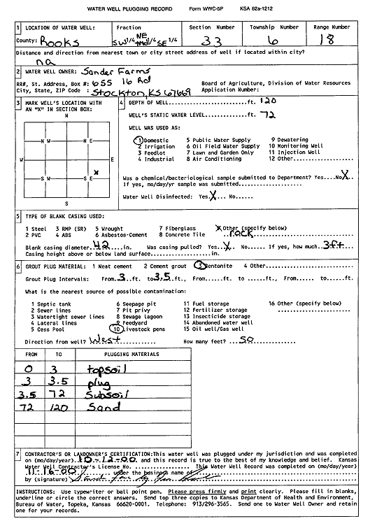
T6S, R18W, Sec. 33 SW NE SE |
Sander Farms | 120 ft. | 72 ft. | Domestic | Plugged | 12-Oct-2000 | Scan | ||
|
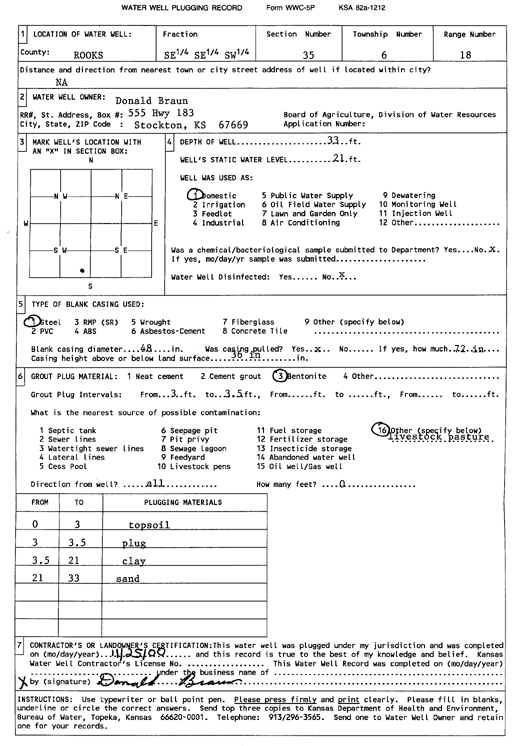
T6S, R18W, Sec. 35 SE SE SW |
Braun, Donald | 33 ft. | 21 ft. | Domestic | Plugged | 25-Nov-2000 | Scan | ||
|
T6S, R18W, Sec. 35 NW SW NW SE |
Niblock, Lee | 30 ft. | 2 ft. | 20 gpm. | Domestic, Livestock | Constructed | 22-Oct-2018 |
KOLAR |
|
|
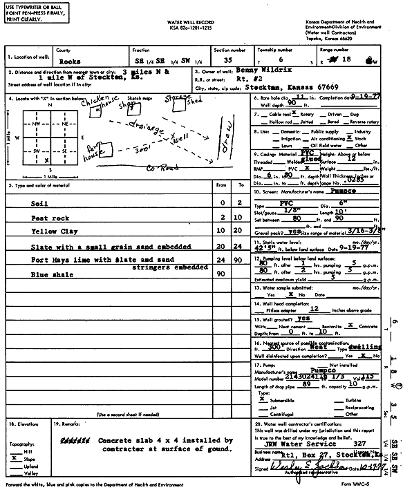
T6S, R18W, Sec. 35 SE SE SW |
Wildrix, Benny | 90 ft. | 42.5 ft. | 5 gpm. | Domestic, Livestock | Constructed | 19-Sep-1977 | Scan | |
|
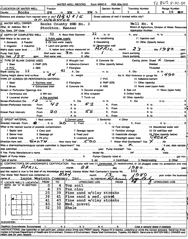
T6S, R19W, Sec. 1 SW NW NW |
Rooks Co. RWD 3 | 52 ft. | 19 ft. | 125 gpm. | Public Water Supply | well 4 | Constructed | 22-Apr-1980 | Scan |
|
T6S, R19W, Sec. 4 SE NE NE |
Brown, Delton | 59 ft. | 12 gpm. | Domestic | Constructed | 01-Apr-2005 | |||
|
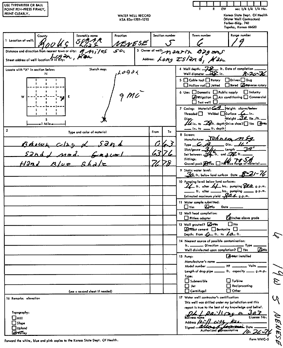
T6S, R19W, Sec. 5 NE NE SE |
Bagens, Martin | 78 ft. | 30 ft. | 800 gpm. | Irrigation | Constructed | 20-Aug-1976 | Scan | |
|
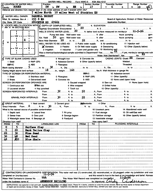
T6S, R19W, Sec. 7 NW NW NE SE |
Brobst, Darrell | 30 ft. | 5 ft. | 17 gpm. | Domestic, Livestock | Constructed | 07-Oct-2012 | ||
|
T6S, R19W, Sec. 7 NE NE NE SE |
Brobst, Darrell | 30 ft. | 15 gpm. | Domestic, Livestock | Constructed | 19-Oct-2012 | |||
|
T6S, R19W, Sec. 8 NE NE SE |
Nix, Pat | 40 ft. | 11 ft. | 12 gpm. | Domestic, Livestock | Constructed | 27-May-2025 |
KOLAR |
|
|
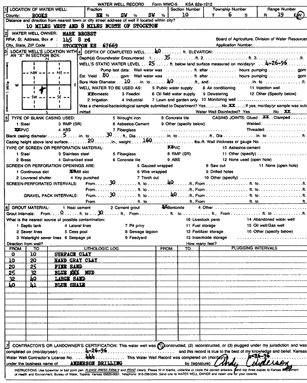
T6S, R19W, Sec. 10 NE SW SW |
Brobst, Mark | 40 ft. | 25 ft. | 80 gpm. | Domestic | Constructed | 26-Apr-1996 | Scan | |
|
T6S, R19W, Sec. 15 NE NW SE |
Stewart, Glenn | 41 ft. | 25 ft. | Domestic, Livestock | Constructed | 30-Apr-2025 |
KOLAR |
||
|
T6S, R19W, Sec. 17 SW SW NE |
Brobst, Darrell | 52 ft. | 20 ft. | 50 gpm. | Domestic | Constructed | 05-Nov-1996 | Scan | |
|
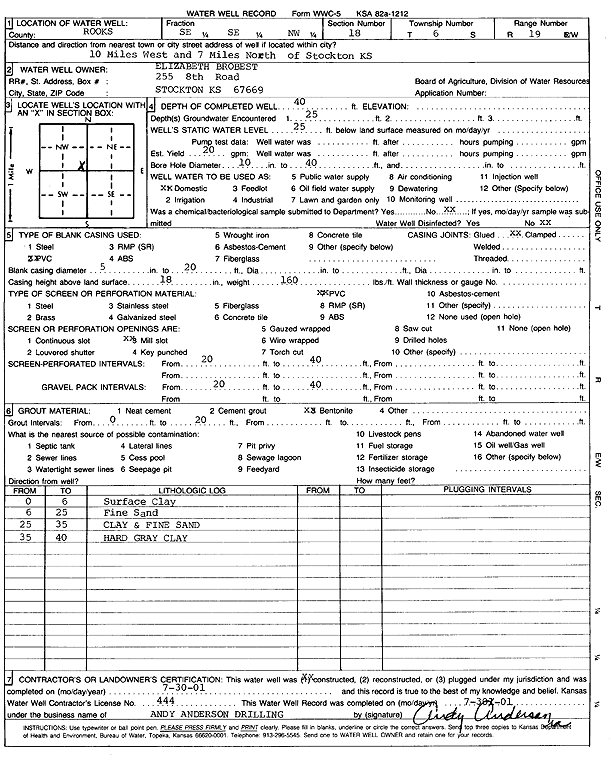
T6S, R19W, Sec. 18 SE SE NW |
Brobst, Elizabeth | 40 ft. | 25 ft. | 20 gpm. | Domestic | Constructed | 30-Jul-2001 | Scan | |
|
T6S, R19W, Sec. 20 NW SE SE |
Hamitt, Don | 19 ft. | 9 ft. | 8 gpm. | Domestic | Constructed | 27-May-2010 | ||
|
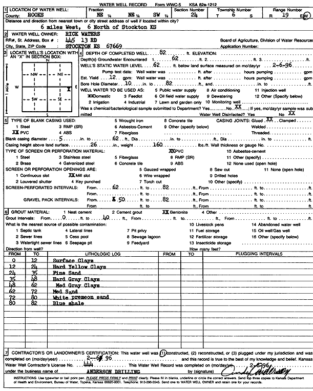
T6S, R19W, Sec. 24 NE NE SW |
Waters, Rick | 82 ft. | 62 ft. | 12 gpm. | Domestic | Constructed | 06-Feb-1996 | Scan | |
|
T6S, R19W, Sec. 29 SE SE NE |
Miller, Kenton | 35 ft. | 33 ft. | Domestic | Plugged | 23-Sep-2004 | |||
|
T6S, R19W, Sec. 29 SE SE NE |
Miller, Kenton | 58 ft. | 40 ft. | 10 gpm. | Domestic | Constructed | 23-Sep-2004 | ||
|
T6S, R19W, Sec. 34 SE NE |
Strutt, Gerald D. and Clara | 14 ft. | 11.5 ft. | 4 gpm. | Domestic, Livestock | Constructed | 28-Apr-2008 | ||
|
T6S, R19W, Sec. 35 SW SE SE |
Fellhoelter, Steve | 38 ft. | 12 ft. | 20 gpm. | Domestic | Constructed | 14-Sep-2007 | ||
|
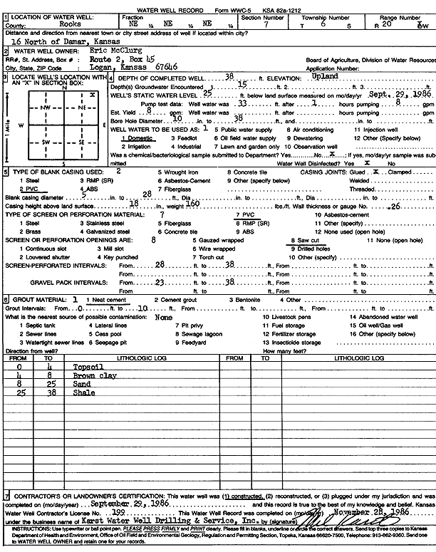
T6S, R20W, Sec. 7 NE NE NE |
McClurg, Eric | 38 ft. | 25 ft. | 8 gpm. | Domestic | Constructed | 29-Sep-1986 | Scan | |
|
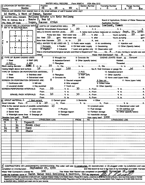
T6S, R20W, Sec. 8 SE SE NW |
McClurg Estate | 30 ft. | 20 ft. | 20 gpm. | Domestic | Constructed | 29-Sep-1986 | Scan | |
|
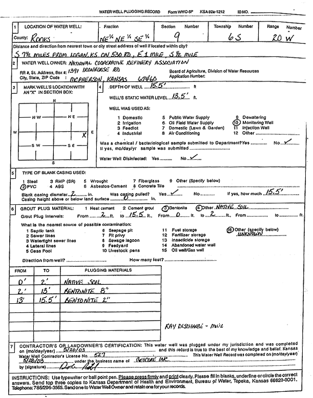
T6S, R20W, Sec. 9 NE NE SE |
National Cooperative Refinery Association | 15.5 ft. | 13.5 ft. | Monitoring well/observation/piezometer | MW 2 | Plugged | 20-May-2003 | Scan | |
|
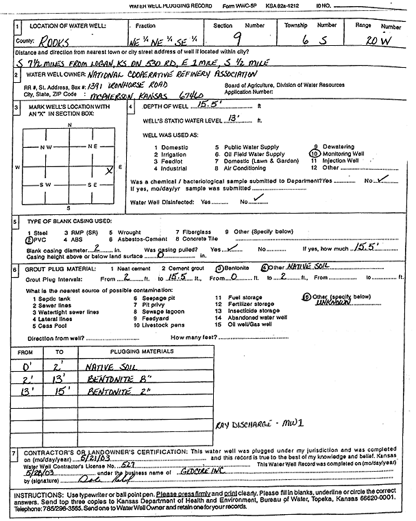
T6S, R20W, Sec. 9 NE NE SE |
National Cooperative Refinery Association | 15.5 ft. | 13 ft. | Monitoring well/observation/piezometer | MW 1 | Plugged | 21-May-2003 | Scan | |
|
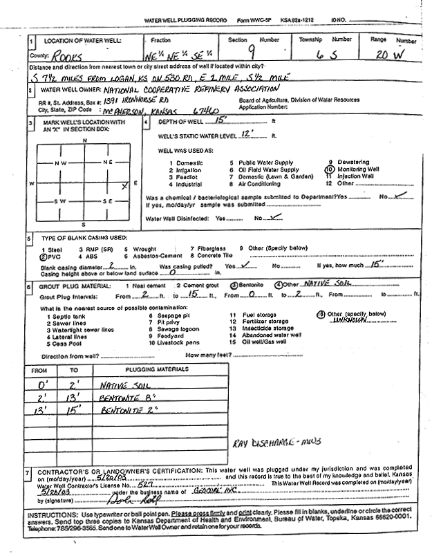
T6S, R20W, Sec. 9 NE NE SE |
National Cooperative Refinery Association | 15 ft. | 12 ft. | Monitoring well/observation/piezometer | MW 3 | Plugged | 20-May-2003 | Scan | |
|
T6S, R20W, Sec. 10 NW |
Kaw Pipeline | 15 ft. | 7 ft. | Monitoring well/observation/piezometer | MW 2 | Constructed | 18-Oct-2000 | Scan | |
|
T6S, R20W, Sec. 10 NW |
Kaw Pipeline | 15 ft. | 7 ft. | Monitoring well/observation/piezometer | MW 3 | Constructed | 18-Oct-2000 | Scan | |
|
T6S, R20W, Sec. 10 NW |
Kaw Pipeline | 15 ft. | 7 ft. | Monitoring well/observation/piezometer | MW 1 | Constructed | 18-Oct-2000 | Scan | |
|
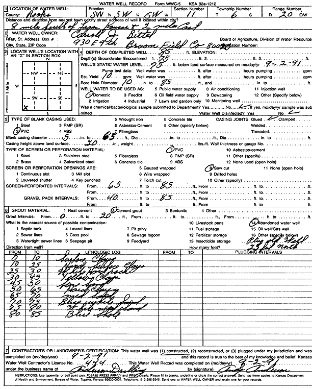
T6S, R20W, Sec. 11 SW SW SW |
Bittel, Carroll J. | 85 ft. | 75 ft. | 10 gpm. | Domestic | Constructed | 02-Sep-1991 | Scan | |
|
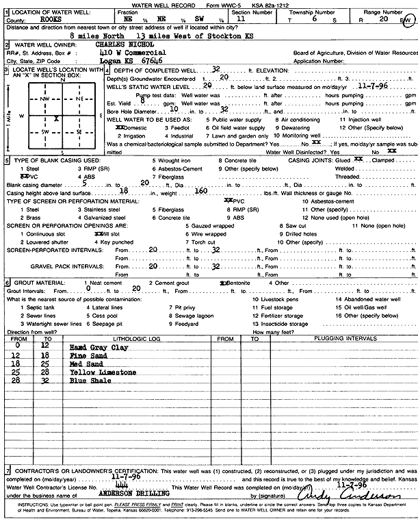
T6S, R20W, Sec. 11 NE NE SW |
Nichol, Charles | 32 ft. | 20 ft. | 8 gpm. | Domestic | Constructed | 07-Nov-1996 | Scan | |
|
T6S, R20W, Sec. 15 SE SE SW SW |
Gartrell, Greg | 80 ft. | 50 ft. | Domestic, Livestock | Plugged | 30-Sep-2020 |
KOLAR |
||
| View page: 1 || 2 || 3 || 4 || 5 || 6 || 7 || 8 || 9 || 10 || Next > | |||||||||