KGS Photo Display System

Excavation Below Rock Shelter on Burntwood Creek
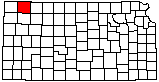
location map
Help Comments
County: Rawlins Subjects: Landscapes --Geoarchaeology
Landscapes --Loess
Outcrops --Ogallala Formation
Landscapes --Excavation Site

photo--if missing then file not yet transferred

Photo courtesy John Charlton/KGS.
July 2006.

Kansas Geological Survey, Educational Resources
Feel free to use photos from the Kansas Geological Survey's collection for any non-commercial use.
Please credit the Kansas Geological Survey for photos you use.
Comments to webadmin@kgs.ku.edu
URL=http://www.kgs.ku.edu/Images/DB/index.html
Program updated Nov. 11, 2004. Photos added periodically.