Coronado Heights (Aerial)
|
|
|
|
|
Coronado Heights (Aerial)
|
|
|
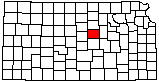
| County: Saline |
Subjects:
--National Register of Historic Places
Outcrops --Dakota Formation Architecture --WPA Structure Architecture --Cemetery Transportation --Kansas Scenic Byways Transportation --Prairie Trail Scenic Byway Landscapes --Aerial Photo --Historic Site |
|
|
|
|
Photo courtesy Daniel F. Merriam/KGS.
1969. | |
