Select location of well to view details.
Click on column heading to sort.
|
|
|
County: Lane Select location of well to view details. Click on column heading to sort. |
|
|
|
| View page: < Prev || 11 || 12 || 13 || 14 || 15 || 16 || 17 || 18 || 19 || 20 | |||||||||
| T-R-S | Owner | Well Depth Ascend. Desc. |
Static Water Level Ascend. Desc. |
Est. Yield Ascend. Desc. |
Well Use | Other ID | Action Taken | Completion Date Ascend. Desc. |
Scan? |
|
T18S, R29W, Sec. 24 NW NW NE |
Chevron Environmental Management Co. | 65 ft. | 51.05 ft. | Monitoring well/observation/piezometer | 3 | Constructed | 22-Jun-2007 | ||
|
T18S, R29W, Sec. 24 NW NW NE |
Chevron Environmental Management Co. | 65 ft. | 51.6 ft. | Monitoring well/observation/piezometer | 8 | Constructed | 07-Jan-2008 | ||
|
T18S, R29W, Sec. 24 NW NW NE |
Chevron Environmental Management Co. | 65 ft. | 51.89 ft. | Monitoring well/observation/piezometer | 12 | Constructed | 30-Jul-2008 | ||
|
T18S, R29W, Sec. 24 NW NW NE |
Chevron Environmental Management Co. | 61.98 ft. | 53.87 ft. | Monitoring well/observation/piezometer | MW 1 | Plugged | 11-Jun-2018 | ||
|
T18S, R29W, Sec. 24 NW NW NE |
Chevron Environmental Management Co. | 60.81 ft. | 52.88 ft. | Monitoring well/observation/piezometer | MW 2 | Plugged | 11-Jun-2018 | ||
|
T18S, R29W, Sec. 24 NW NW NE |
Chevron Environmental Management Co. | 63.88 ft. | 52.65 ft. | Monitoring well/observation/piezometer | MW 3 | Plugged | 11-Jun-2018 | ||
|
T18S, R29W, Sec. 24 NW NW NE |
Chevron Environmental Management Co. | 67.02 ft. | 53.85 ft. | Monitoring well/observation/piezometer | MW 3 A | Plugged | 11-Jun-2018 | ||
|
T18S, R29W, Sec. 24 NW NW NE |
Chevron Environmental Management Co. | 60.99 ft. | 52.86 ft. | Monitoring well/observation/piezometer | MW 5 | Plugged | 11-Jun-2018 | ||
|
T18S, R29W, Sec. 24 NW NW NE |
Chevron Environmental Management Co. | 65 ft. | 50.08 ft. | Monitoring well/observation/piezometer | 13 | Constructed | 29-Jul-2008 | ||
|
T18S, R29W, Sec. 24 NW NW NE |
Chevron Environmental Management Co. | 63.32 ft. | 54.04 ft. | Monitoring well/observation/piezometer | MW 6 | Plugged | 11-Jun-2018 | ||
|
T18S, R29W, Sec. 24 NW NW NE |
Chevron Environmental Management Co. | 55.67 ft. | 53.43 ft. | Monitoring well/observation/piezometer | MW 8 | Plugged | 11-Jun-2018 | ||
|
T18S, R29W, Sec. 24 NW NW NE |
Chevron Environmental Management Co. | 57.01 ft. | 53.85 ft. | Monitoring well/observation/piezometer | MW 12 | Plugged | 11-Jun-2018 | ||
|
T18S, R29W, Sec. 24 SE SE SE |
Lewis, Eugene | 65 ft. | 41 ft. | Domestic | Constructed | 31-Jul-1985 | |||
|
T18S, R29W, Sec. 24 SE SE SE |
Shapland, Keith | 62 ft. | 26 ft. | 29 gpm. | Domestic | Constructed | 21-Jul-2006 | ||
|
T18S, R29W, Sec. 24 NE SE SE |
Whipple, Rex | 60 ft. | 26 ft. | Domestic, Livestock | Constructed | 04-May-1978 | |||
|
T18S, R29W, Sec. 25 SE SE SW |
Hilgenberg, Robert | 84 ft. | 30 ft. | 5 gpm. | Domestic | Constructed | 01-Aug-1992 | ||
|
T18S, R29W, Sec. 27 SW SE SW |
McWhirter, Neil | 120 ft. | Oil Field Water Supply | Constructed | 27-Sep-2005 | ||||
|
T18S, R29W, Sec. 27 NE NE NW |
McWhirter, Neil | 114 ft. | 35 ft. | 70 gpm. | Domestic, Livestock | Constructed | 23-Jul-2010 | ||
|
T18S, R29W, Sec. 27 NE NE NW |
McWhirter, Neil | 40 ft. | 36 ft. | Domestic, Livestock | Plugged | 23-Jul-2010 | |||
|
T18S, R29W, Sec. 27 NE NE SE NE |
McWhirter, Neil (was Larson Engineering Inc) | 125 ft. | 65 ft. | 50 gpm. | Domestic, changed from Oil Field Water Supply | WR Unit 1-27 | Constructed | 01-Feb-2013 |
KOLAR |
|
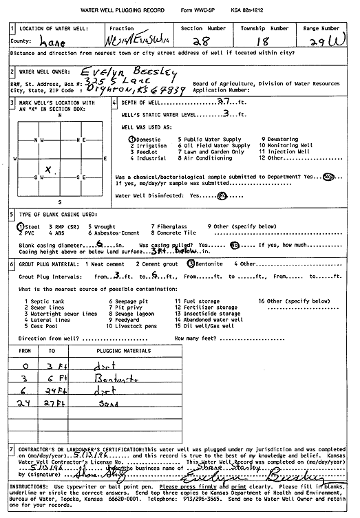
T18S, R29W, Sec. 28 C NE SW |
Beesley, Evelyn | 27 ft. | 3 ft. | Domestic | Plugged | 13-May-1996 | Scan | ||
|
T18S, R29W, Sec. 28 SE NE SE |
Beesley, Evelyn | 63 ft. | 20 ft. | Domestic | Plugged | 13-May-1996 | Scan | ||
|
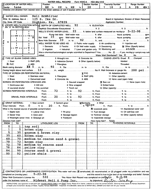
T18S, R29W, Sec. 28 NE SE NE |
McWhirter, Neil | 92 ft. | 22 ft. | 15 gpm. | Domestic, Livestock | Constructed | 22-May-1998 | Scan | |
|
T18S, R29W, Sec. 28 SW SW SW SW |
McWhirter, Neil | 130 ft. | 90 ft. | 20 gpm. | Domestic, Livestock | Constructed | 02-Sep-2014 |
KOLAR |
|
|
T18S, R29W, Sec. 33 SE SE SW |
Murphy, Elvin | 90 ft. | 55 ft. | Domestic | Constructed | 25-Sep-1980 | |||
|
T18S, R29W, Sec. 35 NW NW NW NW |
Paris, Robert | 54 ft. | 24 ft. | Domestic | Plugged | 20-Sep-2011 | |||
|
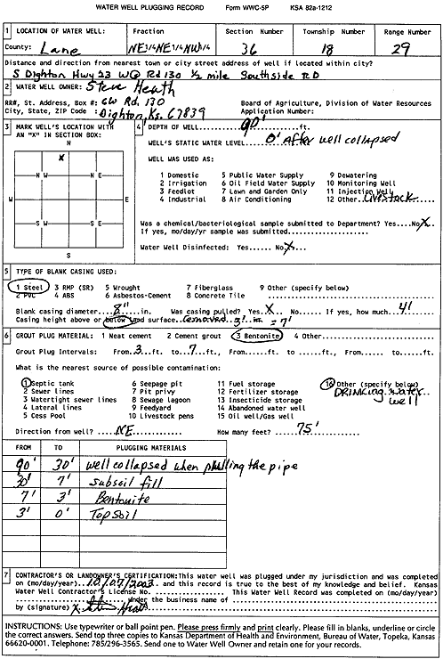
T18S, R29W, Sec. 36 NE NE NW |
Heath, Steve | 90 ft. | Domestic, Livestock | Plugged | 07-Oct-2003 | Scan | |||
|
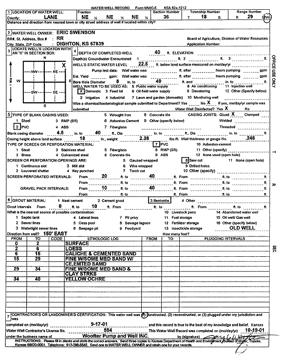
T18S, R29W, Sec. 36 NE NE NE |
Swenson, Eric | 40 ft. | 22.5 ft. | Domestic | Constructed | 17-Sep-2001 | Scan | ||
|
T18S, R30W, Sec. 1 NW NW SW |
Sharp Farms | 130 ft. | 80 ft. | 415 gpm. | Irrigation | Constructed | 05-Mar-1977 | ||
|
T18S, R30W, Sec. 1 C S2 NE |
Sharp Farms | 133 ft. | 80 ft. | 106 gpm. | Irrigation | Constructed | 27-May-1983 | ||
|
T18S, R30W, Sec. 1 NE SW NE |
Sharp Seed Farms | 133 ft. | 82 ft. | Irrigation | Plugged | 07-May-1992 | |||
|
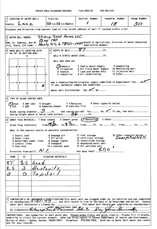
T18S, R30W, Sec. 1 SE SE SW |
Sharp Seed Farms | 87 ft. | Domestic | Plugged | 21-Jun-1999 | Scan | |||
|
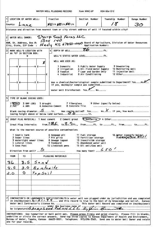
T18S, R30W, Sec. 1 NE NE NE |
Sharp Seed Farms | 86 ft. | (unstated)/abandoned | Plugged | 21-Jun-1999 | Scan | |||
|
T18S, R30W, Sec. 2 NW NW NW NW |
University of Kansas | 140 ft. | 125 ft. | Monitoring well/observation/piezometer | Monitoring | Constructed | 30-Mar-2016 |
KOLAR |
|
|
T18S, R30W, Sec. 2 NE SW SW |
West, Wilson | 136 ft. | 86 ft. | 370 gpm. | Irrigation | Constructed | 09-Mar-1976 | ||
|
T18S, R30W, Sec. 3 NE SW SW |
Dunn and Gardner | 105 ft. | 65 ft. | Oil Field Water Supply | Constructed | 30-Aug-1978 | |||
|
T18S, R30W, Sec. 3 SE NE NW |
Sharp Farms | 135 ft. | 81 ft. | 500 gpm. | Irrigation | Constructed | 18-Apr-1980 | ||
|
T18S, R30W, Sec. 3 SE SW NW |
Sharp, Mr. and Mrs. Gail E. | 134 ft. | 85 ft. | Irrigation | Constructed | 04-Jan-1984 | |||
|
T18S, R30W, Sec. 4 NW NE NW |
Sharp Farms | 130 ft. | 70 ft. | 580 gpm. | Irrigation | Constructed | 08-Apr-1976 | ||
|
T18S, R30W, Sec. 4 NW NW NE |
Sharp Farms | 133 ft. | 75 ft. | 640 gpm. | Irrigation | Constructed | 29-Oct-1975 | ||
|
T18S, R30W, Sec. 4 SE NE NE |
Sharp Farms | 132 ft. | 80 ft. | 730 gpm. | Irrigation | Constructed | 29-Jun-1977 | ||
|
T18S, R30W, Sec. 4 SE SE SE |
Shull, Curtis | 125 ft. | 77 ft. | Domestic, Livestock | Constructed | 15-May-1980 | |||
|
T18S, R30W, Sec. 5 NE NE NE |
Doll, Wayne | 132 ft. | 75 ft. | Domestic | Constructed | 07-Mar-1979 | |||
|
T18S, R30W, Sec. 6 NW NE SW |
Ramsey, Jon | 133 ft. | Oil Field Water Supply | Constructed | 19-Feb-2005 | ||||
|
T18S, R30W, Sec. 6 SE NW NW |
Warrior Drilling | 137 ft. | 70 ft. | 60 gpm. | Oil Field Water Supply | Constructed | 08-Feb-1987 | ||
|
T18S, R30W, Sec. 7 SW NW SW |
Herndon, Walter | 150 ft. | 70 ft. | 550 gpm. | Irrigation | Constructed | 22-Feb-1977 | ||
|
T18S, R30W, Sec. 8 NE SE SE |
Gustavson, Kennett | 135 ft. | 88 ft. | 10 gpm. | Domestic, Livestock | Constructed | 24-Jun-1978 | ||
|
T18S, R30W, Sec. 9 SW SE NE |
Herndon, Joel | 93 ft. | 88 ft. | Domestic | Plugged | 18-Sep-2015 | |||
|
T18S, R30W, Sec. 9 SW SE NE |
Herndon, Joel | 130 ft. | 91 ft. | 50 gpm. | Domestic | Constructed | 18-Sep-2015 | ||
|
T18S, R30W, Sec. 9 NE SW NE |
Herndon, Owen | 127 ft. | 60 ft. | 500 gpm. | Irrigation | Constructed | 31-Mar-1977 | ||
| View page: < Prev || 11 || 12 || 13 || 14 || 15 || 16 || 17 || 18 || 19 || 20 | |||||||||