Select location of well to view details.
Click on column heading to sort.
|
|
|
County: Lane Select location of well to view details. Click on column heading to sort. |
|
|
|
| View page: 1 || 2 || 3 || 4 || 5 || 6 || 7 || 8 || 9 || 10 || Next > | |||||||||
| T-R-S | Owner | Well Depth Ascend. Desc. |
Static Water Level Ascend. Desc. |
Est. Yield Ascend. Desc. |
Well Use | Other ID | Action Taken | Completion Date Ascend. Desc. |
Scan? |
|
T17S, R29W, Sec. 23 SE SW NE |
Honeyman, Allan | 160 ft. | 102 ft. | Oil Field Water Supply | Plugged | 06-Aug-2008 | |||
|
T17S, R29W, Sec. 23 SE SW NE |
Honeyman, Allen | 160 ft. | 102 ft. | Oil Field Water Supply | Constructed | 16-May-2007 | |||
|
T17S, R29W, Sec. 23 C NW NE |
Shapland, Claude/Slawson Drilling | 140 ft. | 90 ft. | Oil Field Water Supply | Constructed | 20-Jun-1985 | |||
|
T17S, R29W, Sec. 24 NE NE NE |
James, John | 160 ft. | 98 ft. | Domestic | Constructed | 06-Sep-1983 | |||
|
T17S, R29W, Sec. 25 SE NW SW |
Penka, Victor | 71 ft. | 38 ft. | 20 gpm. | Domestic | Constructed | 20-Oct-1989 | ||
|
T17S, R29W, Sec. 25 C NE |
Riley, Bill/White and Ellis Drilling, Inc. | 140 ft. | 80 ft. | 60 gpm. | Oil Field Water Supply | Riley 1 | Constructed | 28-Nov-1984 | |
|
T17S, R29W, Sec. 25 SE NE NE |
White and Ellis Drilling, Inc. | 140 ft. | 80 ft. | Oil Field Water Supply | Riley 1 | Plugged | 12-Dec-1984 | ||
|
T17S, R29W, Sec. 26 NE SE NW |
Riley, Gerald | 164 ft. | 100 ft. | Irrigation | Constructed | 17-Apr-2008 | |||
|
T17S, R29W, Sec. 27 SE SW SE SW |
Richards, Howard | 140 ft. | 68 ft. | 20 gpm. | Domestic, Livestock | Constructed | 14-Nov-2016 | ||
|
T17S, R29W, Sec. 27 SE SE NW |
Richards, Laurence | 142 ft. | 89 ft. | Oil Field Water Supply | Constructed | 15-Sep-1988 | |||
|
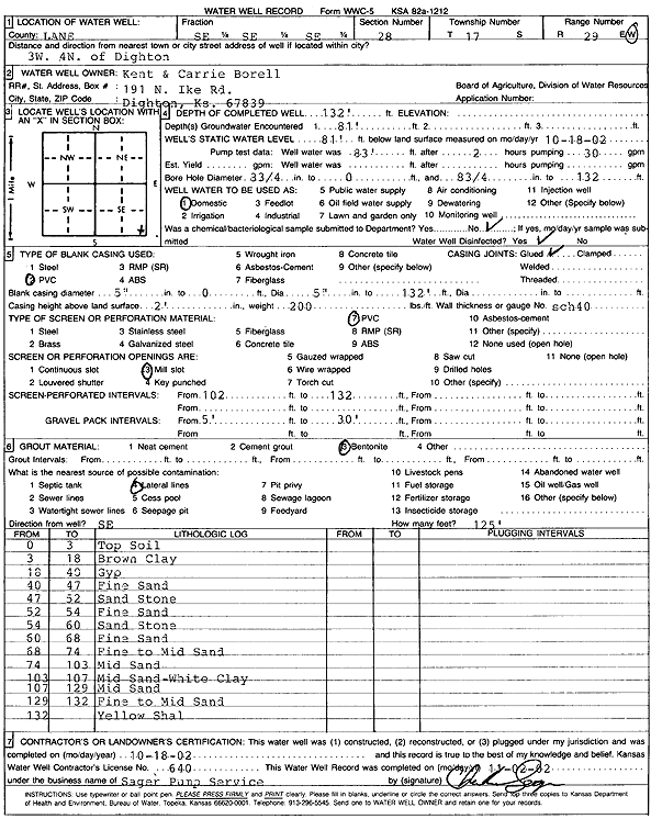
T17S, R29W, Sec. 28 SE SE SE |
Borell, Kent and Carrie | 132 ft. | 81 ft. | Domestic | Constructed | 18-Oct-2002 | Scan | ||
|
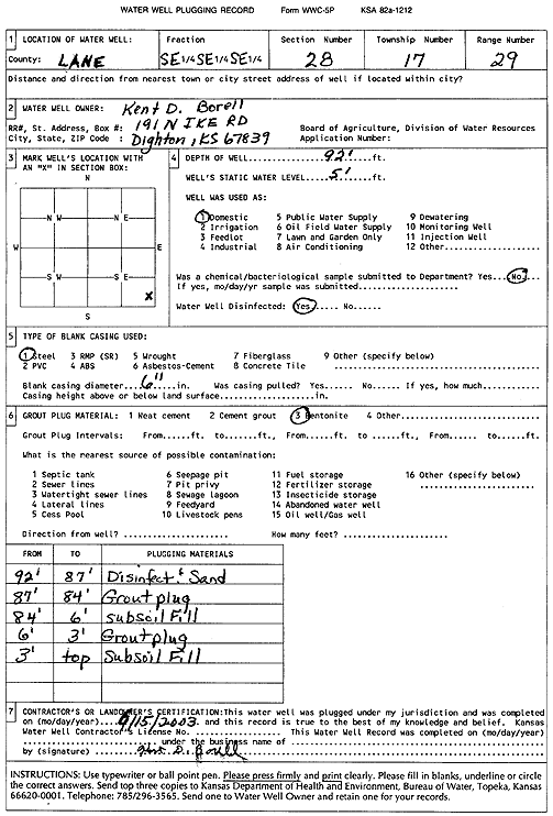
T17S, R29W, Sec. 28 SE SE SE |
Borell, Kent D. | 92 ft. | 5 ft. | Domestic | Plugged | 15-Jun-2003 | Scan | ||
|
T17S, R29W, Sec. 29 NW NW NE |
Zink, Lee | 125 ft. | 84 ft. | Domestic | Constructed | 17-Jul-1986 | |||
|
T17S, R29W, Sec. 30 NW NW NW |
Cramer, Dexter/Murfin Drilling Co. | 100 ft. | 82 ft. | Oil Field Water Supply | Constructed | 16-Dec-1984 | Scan | ||
|
T17S, R29W, Sec. 31 SE NE NE |
Crenic, Rosen | 92 ft. | 30 ft. | Domestic, Livestock | Constructed | 25-Jul-1978 | |||
|
T17S, R29W, Sec. 31 NE SE NW |
Cronic, G./Pickrell Drilling | 120 ft. | 65 ft. | Oil Field Water Supply | Constructed | 18-Oct-1984 | |||
|
T17S, R29W, Sec. 33 NE NW SE |
Pinkston, Marvin | 106 ft. | 70 ft. | 35 gpm. | Domestic, Livestock | Constructed | 11-Sep-2008 | ||
|
T17S, R29W, Sec. 34 SW SW SW |
James, Pete | 100 ft. | 90 ft. | Domestic | Plugged | 20-May-1992 | |||
|
T17S, R29W, Sec. 35 NW SW SE |
Riley, Gerald | 116 ft. | 68 ft. | 350 gpm. | Irrigation | Constructed | 12-Jul-1976 | ||
|
T17S, R29W, Sec. 35 SW SE SW |
Riley, Gerald | 118 ft. | 68 ft. | 350 gpm. | Irrigation | Constructed | 12-Jul-1976 | ||
|
T17S, R29W, Sec. 36 SE SE NW |
Blue Goose Drilling | 125 ft. | 70 ft. | 40 gpm. | Oil Field Water Supply | Constructed | 01-Mar-1986 | ||
|
T17S, R29W, Sec. 36 SE SE NE |
Boomhower, Gene | 115 ft. | 87 ft. | Feedlot | Constructed | 15-Jul-1988 | |||
|
T17S, R29W, Sec. 36 SW SW SW |
Boomhower, Gene | 85 ft. | 10 ft. | Domestic | Plugged | 22-Jun-1995 | |||
|
T17S, R29W, Sec. 36 NE NE SW |
Riley, Alice | 121 ft. | 77 ft. | Oil Field Water Supply | Constructed | 29-Jul-1987 | |||
|
T17S, R30W, Sec. 1 NW SE NW |
Jennison, Karl | 175 ft. | 115 ft. | 450 gpm. | Irrigation | Constructed | 24-May-1979 | ||
|
T17S, R30W, Sec. 1 NW NW NE |
Jennison, Karl | 175 ft. | 112 ft. | 510 gpm. | Irrigation | Constructed | 11-Oct-1976 | ||
|
T17S, R30W, Sec. 1 NW SW NW |
Jennison, Karl | 173 ft. | 118 ft. | 10 gpm. | Domestic | Constructed | 29-Nov-1978 | ||
|
T17S, R30W, Sec. 1 SW SW NW |
Jennison, Karl | 184 ft. | 120 ft. | 520 gpm. | Irrigation | Constructed | 08-Oct-1976 | ||
|
T17S, R30W, Sec. 1 NW NW SE |
Jennison, Karl | 182 ft. | 118 ft. | 300 gpm. | Irrigation | Constructed | 09-Oct-1976 | ||
|
T17S, R30W, Sec. 2 NE NE NW |
Sharp Farms | 178 ft. | 119 ft. | 350 gpm. | Irrigation | Constructed | 04-Mar-1977 | ||
|
T17S, R30W, Sec. 2 SW NW NW |
USD 468, Healy Public Schools | 120 ft. | 119.5 ft. | Public Water Supply | Plugged | 02-Oct-2004 | |||
|
T17S, R30W, Sec. 3 SE NE SE |
Foos, Willard E. | 25.5 ft. | Domestic | Plugged | 19-Oct-1996 | ||||
|
T17S, R30W, Sec. 3 SE NE SE |
Foos, Willard E. | 18.5 ft. | Domestic | Plugged | 19-Oct-1996 | ||||
|
T17S, R30W, Sec. 3 NW SE SE |
Sharp Bros Seed Co | 128 ft. | 107 ft. | Domestic | Cordova | Plugged | 18-May-2012 | ||
|
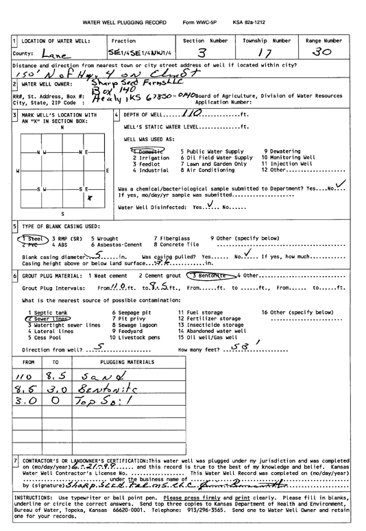
T17S, R30W, Sec. 3 NW SE SE |
Sharp Seed Farms LLC | 123 ft. | 110 ft. | Domestic | Plugged | 20-Mar-2012 | |||
|
T17S, R30W, Sec. 3 NW SE SE |
Sharp Seed Farms LLC | 107 ft. | Domestic | Melbrandt | Plugged | 25-Mar-2012 | |||
|
T17S, R30W, Sec. 3 SE SE NW |
Sharp Seed Farms, LLC | 110 ft. | Domestic | Plugged | 21-Jun-1999 | Scan | |||
|
T17S, R30W, Sec. 3 SE SE NW |
110 ft. | Domestic | Plugged | 21-Jun-1999 | Scan | ||||
|
T17S, R30W, Sec. 4 NW NW SE |
J.L.S. Enterprises | 175 ft. | 116 ft. | Domestic | Constructed | 10-Jul-1986 | |||
|
T17S, R30W, Sec. 4 SE SE SW |
Prairie Fire Bio-Energy | 173 ft. | 114 ft. | 73 gpm. | Domestic | Constructed | 24-Jul-2008 | ||
|
T17S, R30W, Sec. 5 NW NW NW |
Wilkens, Kenneth | 175 ft. | 111 ft. | 470 gpm. | Irrigation | Constructed | 11-Mar-1976 | ||
|
T17S, R30W, Sec. 6 NW SW SW |
Brook, Bryan | 180 ft. | 122 ft. | Domestic | Constructed | 16-Nov-1977 | |||
|
T17S, R30W, Sec. 6 NW SE SE |
151 ft. | 125.5 ft. | Domestic | Plugged | 20-Mar-2012 | ||||
|
T17S, R30W, Sec. 7 C SW SE |
Cramer, George | 182 ft. | 116 ft. | Oil Field Water Supply | Cramer 1-7 | Constructed | 07-Jul-1985 | ||
|
T17S, R30W, Sec. 7 SE NE NW |
Cramer, Keith | 172 ft. | 107 ft. | 550 gpm. | Irrigation | Constructed | 17-Mar-1977 | ||
|
T17S, R30W, Sec. 7 NE NW NW |
Cramer, Keith | 172 ft. | 104 ft. | 540 gpm. | Irrigation | Constructed | 04-Apr-1977 | ||
|
T17S, R30W, Sec. 7 NW NE NE |
Cramer, Keith | 176 ft. | 107 ft. | Domestic | Constructed | 06-Jul-1977 | |||
|
T17S, R30W, Sec. 7 SE NE NW |
Cramer, Keith | 175 ft. | 115 ft. | Domestic | Constructed | 29-Jun-1989 | |||
|
T17S, R30W, Sec. 8 NW NW NW |
Graves, Johnnie | 175 ft. | 100 ft. | Domestic | Constructed | 08-Jul-1976 | |||
|
T17S, R30W, Sec. 9 SE NW SW |
Graves Farms | 175 ft. | 105 ft. | 500 gpm. | Irrigation | Constructed | 01-Apr-1981 | ||
| View page: 1 || 2 || 3 || 4 || 5 || 6 || 7 || 8 || 9 || 10 || Next > | |||||||||