Select location of well to view details.
Click on column heading to sort.
|
|
|
County: Leavenworth Select location of well to view details. Click on column heading to sort. |
|
|
|
| View page: < Prev || 31 || 32 || 33 || 34 || 35 || 36 || 37 || 38 || 39 || 40 || Next > | |||||||||
| T-R-S | Owner | Well Depth Ascend. Desc. |
Static Water Level Ascend. Desc. |
Est. Yield Ascend. Desc. |
Well Use | Other ID | Action Taken | Completion Date Ascend. Desc. |
Scan? |
|
T11S, R20E, Sec. 36 NE SE SW |
Grinter, J.W. | 82 ft. | 26.9 ft. | Domestic | Constructed | 26-Apr-1973 | |||
|
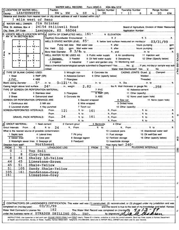
T11S, R20E, Sec. 36 NW NW SE |
Grinter, Jim | 161 ft. | 85 ft. | 50 gpm. | Domestic | Constructed | 31-Mar-1999 | Scan | |
|
T11S, R20E, Sec. 36 SW SW SW |
Grinter, Tom | 129 ft. | 64 ft. | 40 gpm. | Domestic | Constructed | 05-Jun-1976 | ||
|
T11S, R20E, Sec. 36 SW SW NW |
Hagenbuck, Frank | 140 ft. | 30 ft. | 3 gpm. | Domestic | Constructed | 19-Apr-1982 | ||
|
T11S, R20E, Sec. 36 SW NW SW |
Ohara, Pat | 160 ft. | 49 ft. | 30 gpm. | Domestic | Constructed | 27-Jan-2005 | ||
|
T11S, R20E, Sec. 36 SE SW SE |
Strunk, Rex | 85 ft. | 18 ft. | 20 gpm. | Domestic | Constructed | 26-Aug-1986 | ||
|
T11S, R21E, Sec. 1 SW NW SE |
Breuer, Ray | 60 ft. | 10 ft. | 75 gpm. | Domestic | Constructed | 03-Mar-2006 | ||
|
T11S, R21E, Sec. 1 SW SW SE |
Kelly, Jack | 75 ft. | 25 ft. | 30 gpm. | Domestic | Constructed | 06-Oct-1976 | ||
|
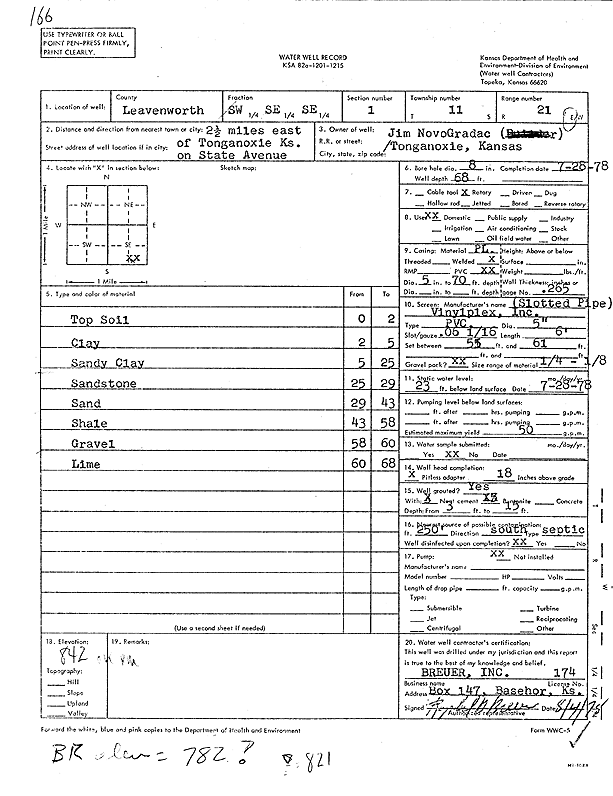
T11S, R21E, Sec. 1 SE SE SE |
NovoGradac, Jim | 68 ft. | 23 ft. | 50 gpm. | Domestic | Constructed | 28-Jul-1978 | Scan | |
|
T11S, R21E, Sec. 1 SE SW SE |
Novogradac, Paul | 74 ft. | 30 ft. | 5 gpm. | Domestic | Constructed | 22-Jan-1996 | ||
|
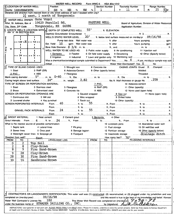
T11S, R21E, Sec. 1 SE NE NW |
Vogel, Gene | 55 ft. | 20 ft. | 10 gpm. | Domestic, Livestock | Constructed | 16-Sep-1998 | Scan | |
|
T11S, R21E, Sec. 1 NE NW NW |
Vogel, Gene | 140 ft. | 79 ft. | 10 gpm. | Domestic | Constructed | 20-Apr-1990 | ||
|
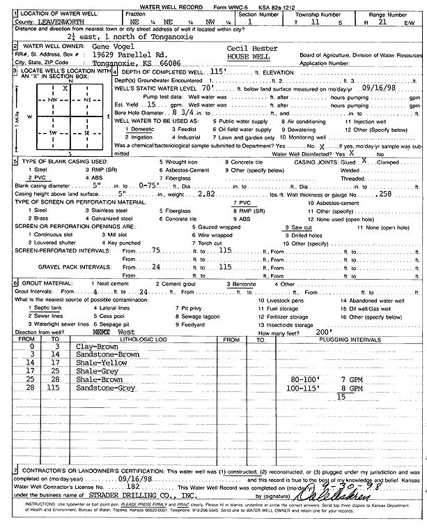
T11S, R21E, Sec. 1 NE NE NW |
Vogel, Gene | 115 ft. | 70 ft. | 15 gpm. | Domestic | Constructed | 16-Sep-1998 | Scan | |
|
T11S, R21E, Sec. 2 NW NW NE |
., Rural Water District No. 9 | 122 ft. | 83 ft. | Test hole/well | TW1-21 | Plugged | 09-Sep-2024 |
KOLAR |
|
|
T11S, R21E, Sec. 2 SW SW NE |
., Rural Water District No. 9 | 150 ft. | 101 ft. | Test hole/well | Tw21 | Plugged | 09-Sep-2024 |
KOLAR |
|
|
T11S, R21E, Sec. 2 NW NW NE |
., Rural WAter District No.9 | 121 ft. | 85 ft. | Test hole/well | Plugged | 09-Sep-2024 |
KOLAR |
||
|
T11S, R21E, Sec. 2 SW SW NE |
., Rural WAter District No.9 | 150 ft. | 101 ft. | Test hole/well | Plugged | 09-Sep-2024 |
KOLAR |
||
|
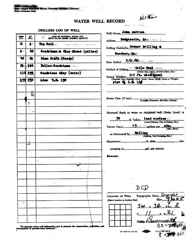
T11S, R21E, Sec. 2 SW SE |
DeFries, John | 139 ft. | 70 ft. | 25 gpm. | (unstated)/abandoned | Constructed | 12-May-1960 | Scan | |
|
T11S, R21E, Sec. 2 SW NW NW NE |
Leavenworth Co. RWD 9 | 122 ft. | 80 ft. | Test Hole, Cased | TW 1-21 | Constructed | 01-Dec-2021 |
KOLAR |
|
|
T11S, R21E, Sec. 2 NW SW SW NE |
Leavenworth Co. RWD 9 | 145 ft. | 99 ft. | 60 gpm. | Test Hole, Cased | TW 2-21 | Constructed | 10-Jun-2021 |
KOLAR |
|
T11S, R21E, Sec. 3 NE NE NW |
Goepfert, Delbert | 100 ft. | 15 ft. | 4 gpm. | Domestic | Constructed | 19-Jul-1985 | ||
|
T11S, R21E, Sec. 3 NE NE NW |
Goepfert, Delbert | 26 ft. | 20 ft. | Domestic | Plugged | 07-May-1991 | |||
|
T11S, R21E, Sec. 3 SE NE SE |
Leavenworth Co. RWD 9 | 105 ft. | 49 ft. | 40 gpm. | Public Water Supply | Well 6 | Constructed | 21-Aug-2025 |
KOLAR |
|
T11S, R21E, Sec. 3 NE SE SE |
Leavenworth Co. RWD 9 | 84 ft. | 33 ft. | 28 gpm. | Public Water Supply | Well 7 | Constructed | 19-Aug-2025 |
KOLAR |
|
T11S, R21E, Sec. 3 SE SE SE SE |
Leavenworth Co. RWD 9 | 100 ft. | 46 ft. | 200 gpm. | Test Hole, Cased | TW 3-21 | Constructed | 09-Jun-2021 |
KOLAR |
|
T11S, R21E, Sec. 3 NE SE NE SE |
Leavenworth Co. RWD 9 | 116 ft. | 58 ft. | 54 gpm. | Test Hole, Cased | TH 4-21 | Constructed | 10-Jun-2021 |
KOLAR |
|
T11S, R21E, Sec. 3 SE NE NE |
Leavenworth Co. RWD 9 | 139.4 ft. | 70 ft. | Public Water Supply | Plugged | 18-Sep-2019 | |||
|
T11S, R21E, Sec. 3 NE NW NE |
Patterson, Keith | 100 ft. | 46 ft. | 5 gpm. | Domestic | Constructed | 27-Aug-1996 | ||
|
T11S, R21E, Sec. 3 SE NE NW |
Spafford, R.E. | 160 ft. | 15 ft. | 1.5 gpm. | Domestic | Constructed | 22-Feb-1977 | ||
|
T11S, R21E, Sec. 3 NW NW NE |
Suburban Water Co. | 65 ft. | 26 ft. | 30 gpm. | Monitoring well/observation/piezometer | Constructed | 25-Feb-1987 | ||
|
T11S, R21E, Sec. 3 SE SE NW |
Waters, Frank | 155 ft. | 29 ft. | 1 gpm. | Domestic | Constructed | 01-Jul-1968 | ||
|
T11S, R21E, Sec. 4 SW SW SE |
Adcox, Charles | 50 ft. | 20 ft. | 5 gpm. | Domestic | Constructed | 25-Dec-1979 | ||
|
T11S, R21E, Sec. 4 SW NE SW |
Gibbens, Mike and Nancy | 75 ft. | 20 ft. | 4 gpm. | Domestic | Constructed | 15-Jul-1992 | ||
|
T11S, R21E, Sec. 4 NE NE SW |
Nelson, Dan | 50 ft. | 20 ft. | Domestic | Plugged | 17-Apr-2006 | |||
|
T11S, R21E, Sec. 4 SE SE SW |
Novogradac, Jim | 57 ft. | 20 ft. | 55 gpm. | Domestic | Constructed | 18-Jul-1988 | ||
|
T11S, R21E, Sec. 4 SE SW SW |
Tonganoxie Motel | 115 ft. | .25 gpm. | (unstated)/abandoned | Constructed | 04-Aug-1955 | |||
|
T11S, R21E, Sec. 5 NE NW SE |
Goepfert, Delbert | 136.5 ft. | 3.5 ft. | Domestic | Constructed | 30-Apr-1973 | |||
|
T11S, R21E, Sec. 5 SE NW SE NW |
Meitler, Brian | 250 ft. | 62 ft. | 3 gpm. | Domestic | Constructed | 09-Sep-2015 |
KOLAR |
|
|
T11S, R21E, Sec. 5 SW SE NW |
Wolf, Don | 330 ft. | (unstated)/abandoned | Constructed | 03-Nov-1971 | ||||
|
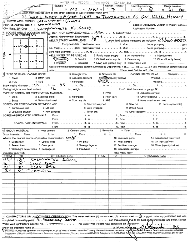
T11S, R21E, Sec. 7 NE NW |
Leavenworth County | 42 ft. | 18 ft. | Domestic | Plugged | 02-Feb-2000 | Scan | ||
|
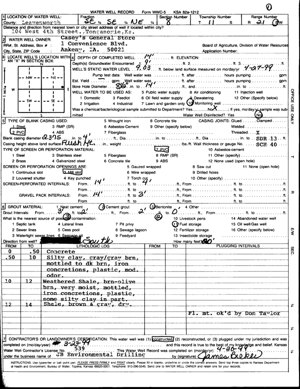
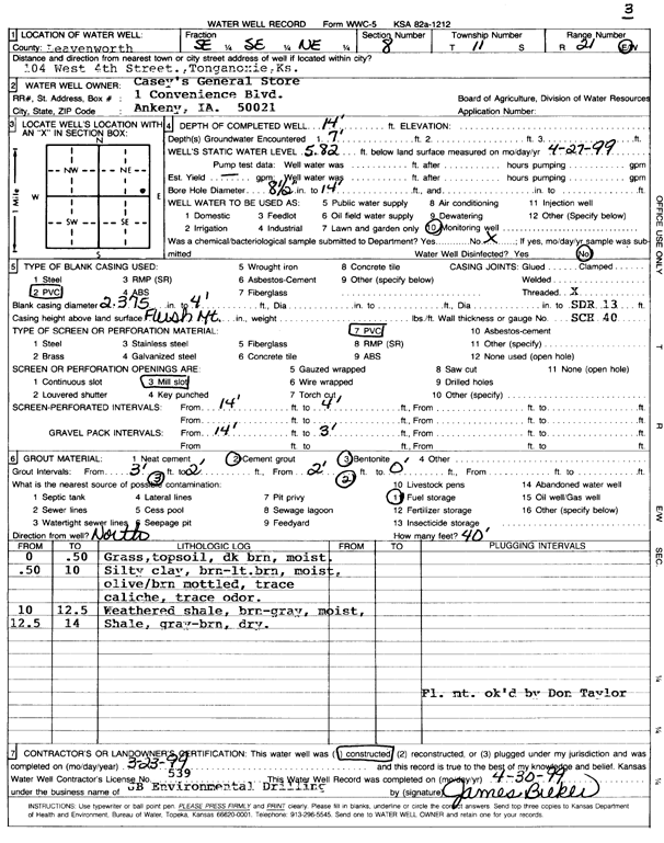
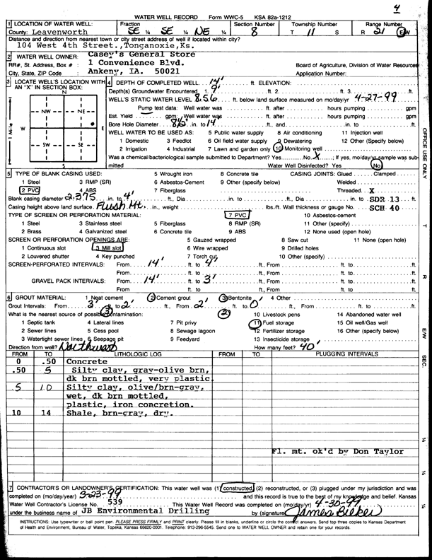
T11S, R21E, Sec. 8 SE SE NE |
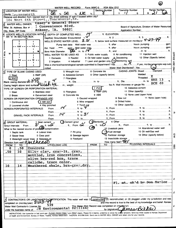
Casey's General Store | 14 ft. | 9.03 ft. | Monitoring well/observation/piezometer | MW 1 | Constructed | 23-Mar-1999 | Scan | |
|
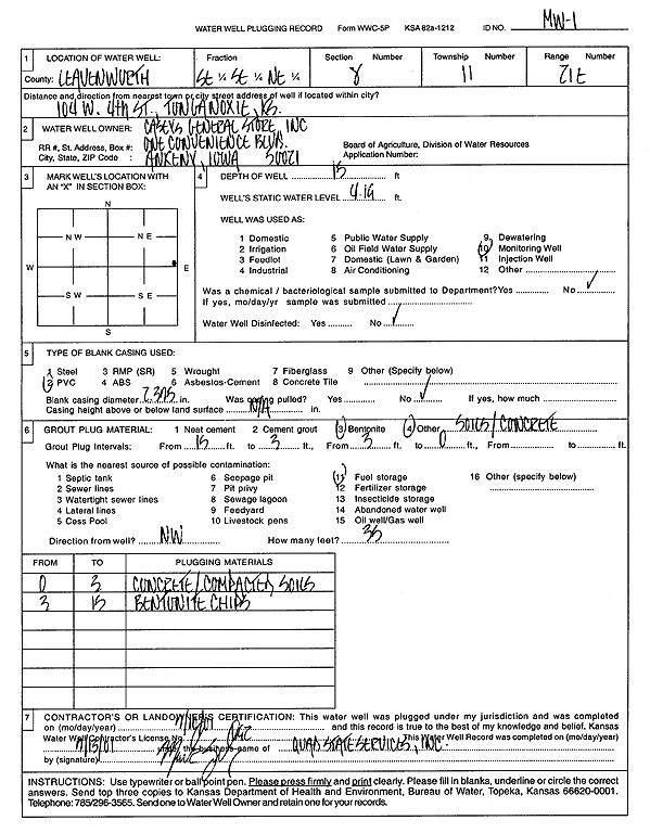
T11S, R21E, Sec. 8 SE SE NE |
Casey's General Store | 15 ft. | 4.19 ft. | Monitoring well/observation/piezometer | MW 1 | Plugged | 10-Jul-2001 | Scan | |
|
T11S, R21E, Sec. 8 SE SE NE |
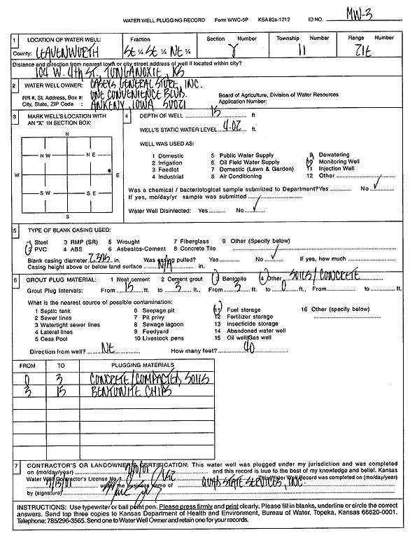
Casey's General Store | 15 ft. | 4.02 ft. | Monitoring well/observation/piezometer | MW 3 | Plugged | 10-Jul-2001 | Scan | |
|
T11S, R21E, Sec. 8 SE SE NE |
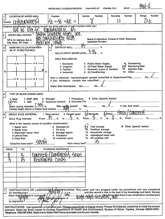
Casey's General Store | 15 ft. | 3.76 ft. | Monitoring well/observation/piezometer | MW 4 | Plugged | 10-Jul-2001 | Scan | |
|
T11S, R21E, Sec. 8 SE SE NE |
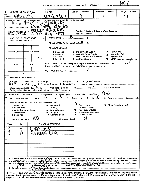
Casey's General Store | 14 ft. | 3.51 ft. | Monitoring well/observation/piezometer | MW 2 | Constructed | 23-Mar-1999 | Scan | |
|
T11S, R21E, Sec. 8 SE SE NE |
Casey's General Store | 15 ft. | 4.1 ft. | Monitoring well/observation/piezometer | MW 2 | Plugged | 10-Jul-2001 | Scan | |
|
T11S, R21E, Sec. 8 SE SE NE |
Casey's General Store | 14 ft. | 5.82 ft. | Monitoring well/observation/piezometer | MW 3 | Constructed | 23-Mar-1999 | Scan | |
|
T11S, R21E, Sec. 8 SE SE NE |
Casey's General Store | 14 ft. | 8.56 ft. | Monitoring well/observation/piezometer | MW 4 | Constructed | 23-Mar-1999 | Scan | |
|
T11S, R21E, Sec. 8 NW NE SE NW |
Ground Source, Inc | 180 ft. | Geothermal, Closed Loop, Vertical | Constructed | 28-Aug-2014 |
KOLAR |
|||
|
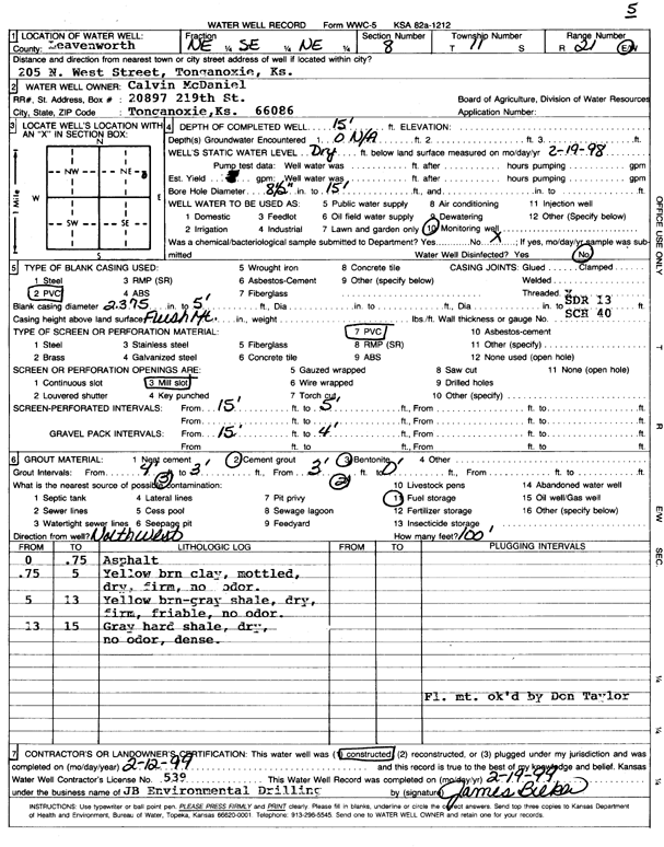
T11S, R21E, Sec. 8 NE SE NE |
McDaniel, Calvin | 15 ft. | Monitoring well/observation/piezometer | MW 5 | Constructed | 12-Feb-1999 | Scan | ||
| View page: < Prev || 31 || 32 || 33 || 34 || 35 || 36 || 37 || 38 || 39 || 40 || Next > | |||||||||