Select location of well to view details.
Click on column heading to sort.
|
|
|
County: Leavenworth Select location of well to view details. Click on column heading to sort. |
|
|
|
| View page: < Prev || 51 || 52 || 53 || 54 || 55 || 56 || 57 | |||||||||
| T-R-S | Owner | Well Depth Ascend. Desc. |
Static Water Level Ascend. Desc. |
Est. Yield Ascend. Desc. |
Well Use | Other ID | Action Taken | Completion Date Ascend. Desc. |
Scan? |
|
T12S, R22E, Sec. 22 SW NW SE |
Orlander, Jay | 49 ft. | 21.05 ft. | Domestic | Constructed | 29-Aug-2007 | |||
|
T12S, R22E, Sec. 22 SW NE |
Spring, C.E. | 30 ft. | Domestic | Constructed | 23-Apr-1973 | ||||
|
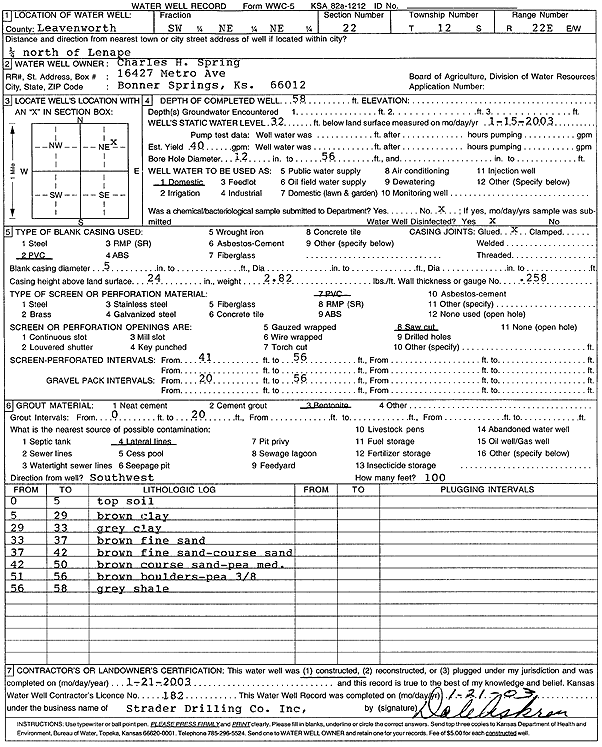
T12S, R22E, Sec. 22 SW NE NE |
Spring, Charles H. | 58 ft. | 32 ft. | 40 gpm. | Domestic | Constructed | 21-Jan-2003 | Scan | |
|
T12S, R22E, Sec. 22 SW NE NE |
Spring, Chet | 56 ft. | 32 ft. | 40 gpm. | Domestic | Constructed | 19-Feb-1990 | ||
|
T12S, R22E, Sec. 22 NW NE NE |
Spring, Chet E. | 38 ft. | 20 ft. | 8 gpm. | Domestic | Constructed | 28-Sep-1979 | ||
|
T12S, R22E, Sec. 22 NE NE NW |
Tinberg Farms | 48 ft. | 25 ft. | 60 gpm. | Domestic | Constructed | 06-Jun-1988 | ||
|
T12S, R22E, Sec. 22 SW SW NE |
Tinberg Farms | 40 ft. | 20 ft. | 40 gpm. | Domestic | Constructed | 03-Jun-1988 | ||
|
T12S, R22E, Sec. 22 NE NE NW |
Tinberg, Ken | 43 ft. | 32 ft. | 20 gpm. | Domestic | Constructed | 29-Sep-1979 | ||
|
T12S, R22E, Sec. 22 NW NE |
Tinberg, Kenneth | 42 ft. | 17 ft. | 20 gpm. | (unstated)/abandoned | Constructed | 16-May-1965 | ||
|
T12S, R22E, Sec. 27 NE NW NE |
City of Olathe | 58 ft. | 17.5 ft. | Monitoring well/observation/piezometer | OB 23 2 E | Constructed | 23-Aug-2007 | ||
|
T12S, R22E, Sec. 27 SE NW NW |
City of Olathe | 60 ft. | Monitoring well/observation/piezometer | TW 22 OB 1 W | Constructed | 14-Nov-2006 | |||
|
T12S, R22E, Sec. 27 SW NE NW |
City of Olathe | 57 ft. | Monitoring well/observation/piezometer | TW 22 OB 1 E | Constructed | 14-Nov-2006 | |||
|
T12S, R22E, Sec. 27 NE NW NE |
City of Olathe | 60 ft. | 18 ft. | Monitoring well/observation/piezometer | OB 23 1 E | Plugged | 09-Oct-2007 | ||
|
T12S, R22E, Sec. 27 NE NW NE |
City of Olathe | 55 ft. | 18 ft. | Monitoring well/observation/piezometer | OB 23 1 N | Plugged | 09-Oct-2007 | ||
|
T12S, R22E, Sec. 27 NE NW NE |
City of Olathe | 56 ft. | 18 ft. | Monitoring well/observation/piezometer | OB 23 2 E | Plugged | 09-Oct-2007 | ||
|
T12S, R22E, Sec. 27 NW NW NE |
City of Olathe | 58 ft. | 17.51 ft. | Monitoring well/observation/piezometer | OB 23 2 N | Constructed | 28-Aug-2007 | ||
|
T12S, R22E, Sec. 27 SE NW NW |
City of Olathe | 60 ft. | 30 ft. | Test hole/well | TW 22 | Constructed | 28-Dec-2006 | ||
|
T12S, R22E, Sec. 27 SW NW NE NW |
City of Olathe | 68 ft. | 22 ft. | 50 gpm. | Domestic | Constructed | 25-Feb-2016 | ||
|
T12S, R22E, Sec. 27 SE NW NW |
City of Olathe | 60 ft. | 30 ft. | Monitoring well/observation/piezometer | TW 22 OB 1 W | Plugged | 20-Mar-2007 | ||
|
T12S, R22E, Sec. 27 SE NW NW |
City of Olathe | 57 ft. | Monitoring well/observation/piezometer | TW 22 OB 2 W | Constructed | 13-Nov-2006 | |||
|
T12S, R22E, Sec. 27 NE NW NE |
City of Olathe | 60 ft. | Monitoring well/observation/piezometer | OB 23 1 E | Constructed | 21-Aug-2007 | |||
|
T12S, R22E, Sec. 27 SE NW NW |
City of Olathe | 57 ft. | 30 ft. | Monitoring well/observation/piezometer | TW 22 OB 2 W | Plugged | 20-Mar-2007 | ||
|
T12S, R22E, Sec. 27 SE NW NW |
City of Olathe | 60 ft. | 30 ft. | Monitoring well/observation/piezometer | TW 22 OB 1 N | Plugged | 20-Mar-2007 | ||
|
T12S, R22E, Sec. 27 SW NE NW |
City of Olathe | 57 ft. | 30 ft. | Monitoring well/observation/piezometer | TW 22 OB 1 E | Plugged | 20-Mar-2007 | ||
|
T12S, R22E, Sec. 27 SE NW NW |
City of Olathe | 60 ft. | Monitoring well/observation/piezometer | TW 22 OB 1 N | Constructed | 14-Nov-2006 | |||
|
T12S, R22E, Sec. 27 NW NW NE |
City of Olathe | 58 ft. | 17.78 ft. | Monitoring well/observation/piezometer | OB 23 1 W | Constructed | 24-Aug-2007 | ||
|
T12S, R22E, Sec. 27 NW NW NE |
City of Olathe | 56 ft. | 18 ft. | Monitoring well/observation/piezometer | OB 23-2 N | Plugged | 09-Oct-2007 | ||
|
T12S, R22E, Sec. 27 NW NW NE |
City of Olathe | 58 ft. | 17.8 ft. | Monitoring well/observation/piezometer | OB 23 1 W | Plugged | 05-Dec-2007 | ||
|
T12S, R22E, Sec. 27 NE NW NE |
City of Olathe | 57 ft. | 17.44 ft. | Monitoring well/observation/piezometer | OB 23 1 N | Constructed | 28-Aug-2007 | ||
|
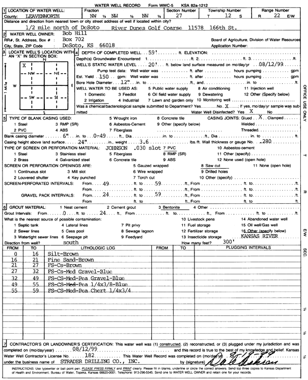
T12S, R22E, Sec. 27 NW NW NW |
Hill, Bob | 59 ft. | 20 ft. | 150 gpm. | Irrigation | Constructed | 12-Aug-1999 | Scan | |
|
T12S, R22E, Sec. 27 NW NE NW NW |
Kansas Geological Survey | 65 ft. | 16.6 ft. | Monitoring well/observation/piezometer | KAW-LV01 | Constructed | 08-May-2018 | ||
|
T12S, R22E, Sec. 28 SE NE NE |
City of Olathe | 58 ft. | 30 ft. | Monitoring well/observation/piezometer | TW 18 OB 1 E | Plugged | 20-Mar-2007 | ||
|
T12S, R22E, Sec. 28 NE NE NE |
City of Olathe | 58 ft. | 30 ft. | Monitoring well/observation/piezometer | OB 19-06 | Plugged | 20-Mar-2007 | ||
|
T12S, R22E, Sec. 28 SE NE NE |
City of Olathe | 60 ft. | 30 ft. | Monitoring well/observation/piezometer | TW 18 OB 2 N | Plugged | 20-Mar-2007 | ||
|
T12S, R22E, Sec. 28 SE NE NE |
City of Olathe | 55 ft. | 30 ft. | Monitoring well/observation/piezometer | OB 18-06 | Plugged | 20-Mar-2007 | ||
|
T12S, R22E, Sec. 28 SE NE NE |
City of Olathe | 58 ft. | 30 ft. | Monitoring well/observation/piezometer | TW 18 OB 1 N | Plugged | 20-Mar-2007 | ||
|
T12S, R22E, Sec. 28 SE NE NE |
City of Olathe | 60 ft. | Monitoring well/observation/piezometer | TW 18 OB 1 N | Constructed | 06-Nov-2006 | |||
|
T12S, R22E, Sec. 28 SE NE NE |
City of Olathe | 60 ft. | Monitoring well/observation/piezometer | TW 18 OB 1 E | Constructed | 07-Nov-2006 | |||
|
T12S, R22E, Sec. 28 NE NE NE |
City of Olathe | 60 ft. | Monitoring well/observation/piezometer | OB 19-06 | Constructed | 10-Aug-2006 | |||
|
T12S, R22E, Sec. 28 SE NE NE |
City of Olathe | 58 ft. | 30 ft. | Test hole/well | TW 18 | Constructed | 27-Dec-2006 | ||
|
T12S, R22E, Sec. 28 SE NE NE |
City of Olathe | 60 ft. | Monitoring well/observation/piezometer | TW 18 OB 2 E | Constructed | 07-Nov-2006 | |||
|
T12S, R22E, Sec. 28 SE NE NE |
City of Olathe | 60 ft. | Monitoring well/observation/piezometer | TW 18 OB 2 N | Constructed | 07-Nov-2006 | |||
|
T12S, R22E, Sec. 28 SE NE NE |
City of Olathe | 57 ft. | Monitoring well/observation/piezometer | OB 18-06 | Constructed | 07-Aug-2006 | |||
|
T12S, R22E, Sec. 28 SE NE NE |
City of Olathe | 60 ft. | 30 ft. | Monitoring well/observation/piezometer | TW 18 OB 2 E | Plugged | 20-Mar-2007 | ||
|
T12S, R22E, Sec. 28 SE NE NE |
City of Olathe | 56 ft. | 30 ft. | Monitoring well/observation/piezometer | TW 18 | Plugged | 20-Mar-2007 | ||
|
T12S, R22E, Sec. 28 NW NE NE |
Rieke, Walter | 50 ft. | 25 ft. | 60 gpm. | Domestic | Constructed | 05-Jun-1990 | ||
| View page: < Prev || 51 || 52 || 53 || 54 || 55 || 56 || 57 | |||||||||