Select location of well to view details.
Click on column heading to sort.
|
|
|
County: Lyon Select location of well to view details. Click on column heading to sort. |
|
|
|
| View page: < Prev || 11 || 12 || 13 || 14 || 15 || 16 || 17 || 18 || 19 || 20 || Next > | |||||||||
| T-R-S | Owner | Well Depth Ascend. Desc. |
Static Water Level Ascend. Desc. |
Est. Yield Ascend. Desc. |
Well Use | Other ID | Action Taken | Completion Date Ascend. Desc. |
Scan? |
|
T19S, R11E, Sec. 8 SE NE SW |
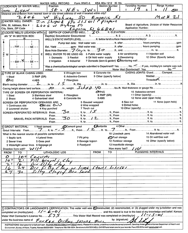
S and S Oil and Propane | 30 ft. | Monitoring well/observation/piezometer | MW 21 | Constructed | 06-Nov-2001 | Scan | ||
|
T19S, R11E, Sec. 8 SE NE SW |
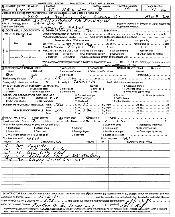
S and S Oil and Propane | 30 ft. | Monitoring well/observation/piezometer | MW 20 | Constructed | 06-Nov-2001 | Scan | ||
|
T19S, R11E, Sec. 8 SE NE SW |
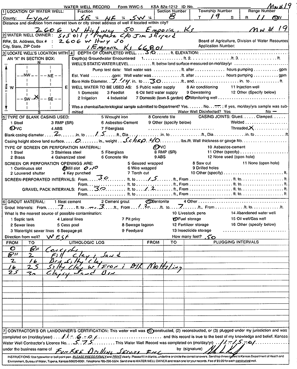
S and S Oil and Propane | 30 ft. | Monitoring well/observation/piezometer | MW 19 | Constructed | 06-Nov-2001 | Scan | ||
|
T19S, R11E, Sec. 8 SE NE SW |
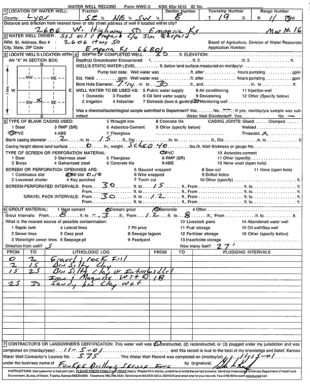
S and S Oil and Propane | 30 ft. | Monitoring well/observation/piezometer | MW 16 | Constructed | 05-Nov-2001 | Scan | ||
|
T19S, R11E, Sec. 8 SE NE SW |
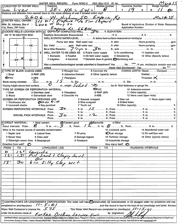
S and S Oil and Propane | 30 ft. | Monitoring well/observation/piezometer | MW 15 | Constructed | 05-Nov-2001 | Scan | ||
|
T19S, R11E, Sec. 8 SE NE SW |
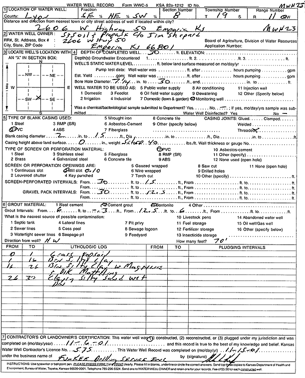
S and S Oil and Propane | 30 ft. | Monitoring well/observation/piezometer | MW 23 | Constructed | 06-Nov-2001 | Scan | ||
|
T19S, R11E, Sec. 8 NE SW SE |
S and S Oil and Propane | 29 ft. | 17.45 ft. | Monitoring well/observation/piezometer | MW 10 | Constructed | 10-Feb-1995 | ||
|
T19S, R11E, Sec. 8 NE SW SE |
S and S Oil and Propane | 29 ft. | 19.3 ft. | Monitoring well/observation/piezometer | MW 7 | Constructed | 08-Feb-1995 | ||
|
T19S, R11E, Sec. 8 NE SW SE |
S and S Oil and Propane | 29 ft. | 20.9 ft. | Monitoring well/observation/piezometer | MW 5 | Constructed | 08-Feb-1995 | ||
|
T19S, R11E, Sec. 8 NE SW SE |
S and S Oil and Propane | 29 ft. | 19.75 ft. | Monitoring well/observation/piezometer | MW 2 | Constructed | 07-Feb-1995 | ||
|
T19S, R11E, Sec. 8 NE SW SE |
S and S Oil and Propane | 29 ft. | 17.82 ft. | Monitoring well/observation/piezometer | MW 8 | Constructed | 09-Feb-1995 | ||
|
T19S, R11E, Sec. 8 SE SW SE |
S and S Oil and Propane | 29 ft. | 19.71 ft. | Monitoring well/observation/piezometer | MW 4 | Constructed | 07-Feb-1995 | ||
|
T19S, R11E, Sec. 8 NE SW SE |
S and S Oil and Propane | 29 ft. | 20.11 ft. | Monitoring well/observation/piezometer | MW 3 | Constructed | 07-Feb-1995 | ||
|
T19S, R11E, Sec. 8 NE SW SE |
S and S Oil and Propane | 29 ft. | 20.5 ft. | Monitoring well/observation/piezometer | MW 6 | Constructed | 08-Feb-1995 | ||
|
T19S, R11E, Sec. 8 NW SE SE |
S and S Oil and Propane | 29 ft. | 17.28 ft. | Monitoring well/observation/piezometer | MW 12 | Constructed | 10-Feb-1995 | ||
|
T19S, R11E, Sec. 8 SE NE SW |
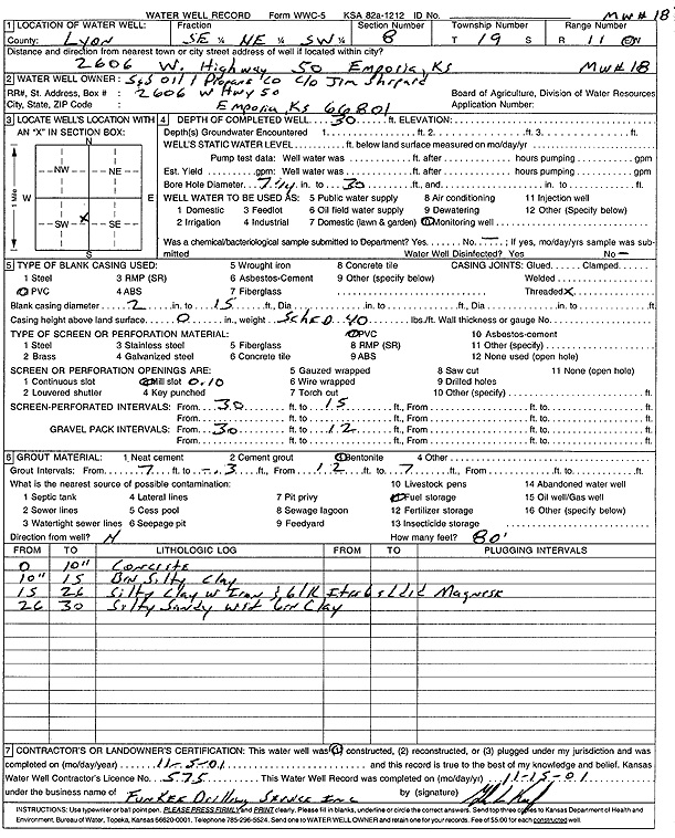
S and S Oil and Propane | 30 ft. | Monitoring well/observation/piezometer | MW 18 | Constructed | 05-Nov-2001 | Scan | ||
|
T19S, R11E, Sec. 8 NE NE SW SE |
Shepherd, Jim | 9.7 ft. | 4.68 ft. | Monitoring well/observation/piezometer | Plugged | 05-Mar-2009 | |||
|
T19S, R11E, Sec. 8 SW SE SW |
Smith, Joyce K. | 42 ft. | 28 ft. | Domestic | Plugged | 15-Dec-1995 | |||
|
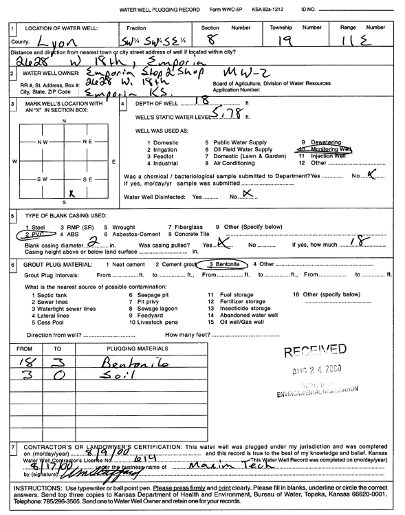
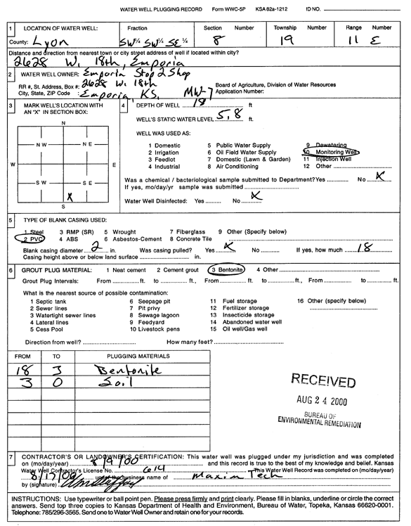
T19S, R11E, Sec. 8 SW SW SE |
Stop 2 Shop | 18 ft. | 5.78 ft. | Monitoring well/observation/piezometer | MW 2 | Plugged | 09-Aug-2000 | Scan | |
|
T19S, R11E, Sec. 8 SW SW SE |
Stop 2 Shop | 18 ft. | 5.8 ft. | Monitoring well/observation/piezometer | MW 7 | Plugged | 09-Aug-2000 | Scan | |
|
T19S, R11E, Sec. 8 NW NW SW |
Wright, Ron | 45 ft. | Monitoring well/observation/piezometer | MW 12 | Constructed | 26-Apr-2007 | |||
|
T19S, R11E, Sec. 9 SE SE SE |
Adams, Elizabeth | 20 ft. | Domestic | Plugged | Scan | ||||
|
T19S, R11E, Sec. 9 NE SW SE |
Anderson, Scott and Jennifer | 43 ft. | 7.5 ft. | Domestic, Lawn and Garden | Plugged | 23-May-2003 | Scan | ||
|
T19S, R11E, Sec. 9 NE SE SW |
Blomenkamp, Larry | 36 ft. | 24 ft. | 20 gpm. | Domestic, Lawn and Garden | Constructed | 19-Nov-1983 | ||
|
T19S, R11E, Sec. 9 SE NW SW |
City of Emporia | 28 ft. | 22 ft. | (unstated)/abandoned | Plugged | 27-Apr-2017 | |||
|
T19S, R11E, Sec. 9 SW SW SW |
Coastal Mart 9197 | 40 ft. | 24.49 ft. | Monitoring well/observation/piezometer | MW 2 | Constructed | 08-Mar-1994 | ||
|
T19S, R11E, Sec. 9 SW SW SW |
Coastal Mart 9197 | 30 ft. | 21.08 ft. | Monitoring well/observation/piezometer | MW 4 | Constructed | 08-Mar-1994 | ||
|
T19S, R11E, Sec. 9 SW SW SW |
Coastal Mart 9197 | 34.6 ft. | Monitoring well/observation/piezometer | MW 1 | Constructed | 04-Jan-1996 | |||
|
T19S, R11E, Sec. 9 SW SW SW |
Coastal Mart 9197 | 35 ft. | 20.83 ft. | Monitoring well/observation/piezometer | MW 3 | Constructed | 08-Mar-1994 | ||
|
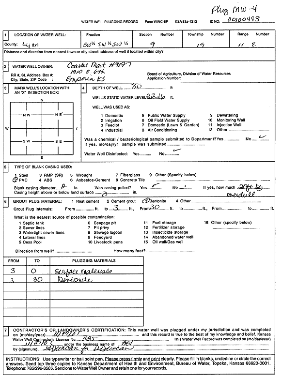
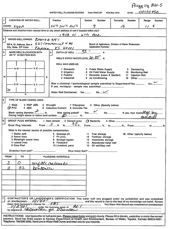
T19S, R11E, Sec. 9 SW SW SW |
Coastal Mart 9197 | 30 ft. | 22.16 ft. | Monitoring well/observation/piezometer | MW 4 | Plugged | 17-Nov-2001 | Scan | |
|
T19S, R11E, Sec. 9 SW SW SW |
Coastal Mart 9197 | 20 ft. | 4.3 ft. | Monitoring well/observation/piezometer | Plugged | 04-Jan-1996 | |||
|
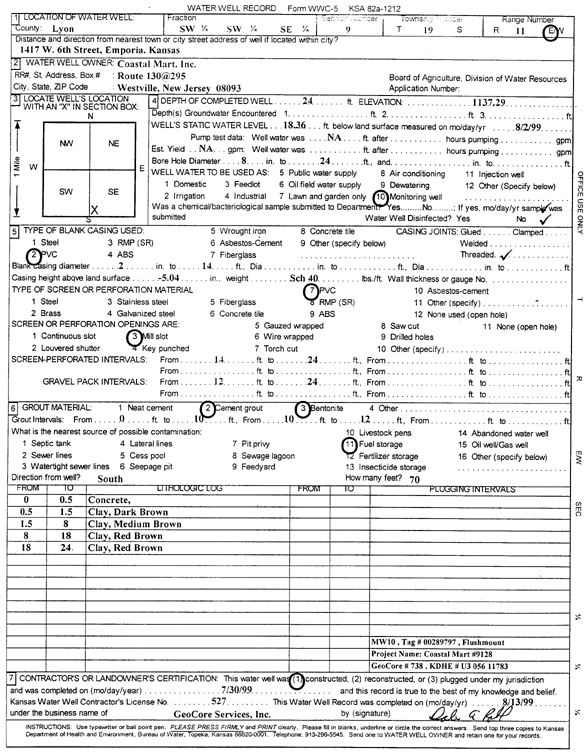
T19S, R11E, Sec. 9 SW SW SE |
Coastal Mart 9197 | 24 ft. | 18.36 ft. | Monitoring well/observation/piezometer | MW 10 | Constructed | 30-Jul-1999 | Scan | |
|
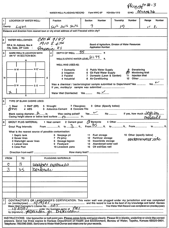
T19S, R11E, Sec. 9 SW SW SW |
Coastal Mart 9197 | 35 ft. | 21.74 ft. | Monitoring well/observation/piezometer | MW 3 | Plugged | 19-Nov-2001 | Scan | |
|
T19S, R11E, Sec. 9 SW SW SW |
Coastal Mart 9197 | 20 ft. | 2.78 ft. | Monitoring well/observation/piezometer | MW 1 | Constructed | 08-Mar-1994 | ||
|
T19S, R11E, Sec. 9 SW SW SW |
Coastal Mart 9197 | 32 ft. | 20.85 ft. | Monitoring well/observation/piezometer | MW 5 | Plugged | 17-Nov-2001 | Scan | |
|
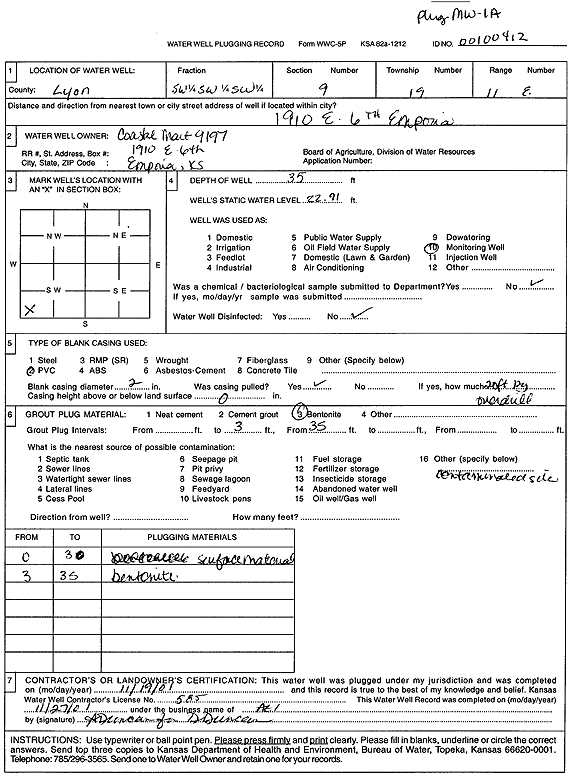
T19S, R11E, Sec. 9 SW SW SW |
Coastal Mart 9197 | 35 ft. | 22.91 ft. | Monitoring well/observation/piezometer | MW 1 A | Plugged | 19-Nov-2001 | Scan | |
|
T19S, R11E, Sec. 9 NE SE SW |
Crist, J.W. | 40 ft. | 22 ft. | 20 gpm. | Domestic, Lawn and Garden | Constructed | 18-May-1984 | ||
|
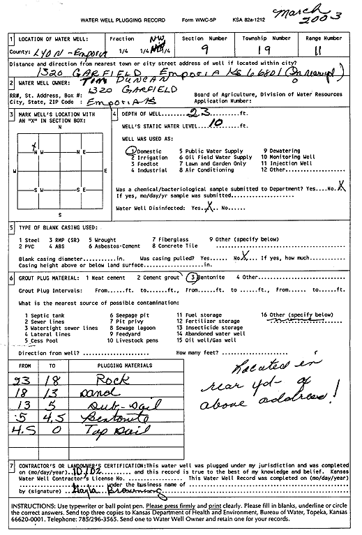
T19S, R11E, Sec. 9 NW NW |
Duncan, Tim | 23 ft. | 10 ft. | Domestic | Plugged | 01-Oct-2002 | Scan | ||
|
T19S, R11E, Sec. 9 SW SW SW |
Felipe, Humberto | 33 ft. | 13 ft. | 50 gpm. | Domestic, Lawn and Garden | Constructed | 27-Jun-1979 | ||
|
T19S, R11E, Sec. 9 NE NE SW |
Feltner, Vernon | 77 ft. | Domestic, Lawn and Garden | Plugged | 27-Sep-1980 | ||||
|
T19S, R11E, Sec. 9 NE NE SW |
Fisher, Rex | 39.5 ft. | 14 ft. | 15 gpm. | Domestic, Lawn and Garden | Constructed | 01-Sep-1990 | ||
|
T19S, R11E, Sec. 9 SW SW SW |
Grover, Robert and Susan | 38 ft. | 35.5 ft. | Domestic | Plugged | 13-Aug-1995 | |||
|
T19S, R11E, Sec. 9 NW NW SE |
Johnson, Eric A. | 27 ft. | 4.5 ft. | Domestic, Lawn and Garden | Plugged | 13-Nov-1993 | |||
|
T19S, R11E, Sec. 9 SE SE SE |
KDHE | 40 ft. | Monitoring well/observation/piezometer | CCMW 1 R | Constructed | 24-Nov-2010 | |||
|
T19S, R11E, Sec. 9 SE SE SE |
KDHE | 30.3 ft. | Environmental Remediation, Injection | CDW 1 | Constructed | 22-Nov-2010 | |||
|
T19S, R11E, Sec. 9 SE SE SE |
KDHE | 30 ft. | Environmental Remediation, Injection | CDW 2 | Constructed | 22-Nov-2010 | |||
|
T19S, R11E, Sec. 9 SE SE SE |
KDHE | 30 ft. | Environmental Remediation, Injection | CDW 3 | Constructed | 23-Nov-2010 | |||
|
T19S, R11E, Sec. 9 SE SE SE |
KDHE | 30 ft. | Environmental Remediation, Injection | CDW 5 | Constructed | 23-Nov-2010 | |||
|
T19S, R11E, Sec. 9 SE SE SE |
KDHE | 30 ft. | Environmental Remediation, Injection | CDW 4 | Constructed | 23-Nov-2010 | |||
|
T19S, R11E, Sec. 9 SE SE SE |
KDHE Drycleaning Release Trust Fund | 30 ft. | 19.16 ft. | Monitoring well/observation/piezometer | CC MW 2 | Constructed | 16-Jun-2006 | ||
| View page: < Prev || 11 || 12 || 13 || 14 || 15 || 16 || 17 || 18 || 19 || 20 || Next > | |||||||||