Select location of well to view details.
Click on column heading to sort.
|
|
|
County: Montgomery Select location of well to view details. Click on column heading to sort. |
|
|
|
| View page: < Prev || 11 || 12 || 13 || 14 || 15 || 16 || 17 || 18 || 19 || 20 || Next > | |||||||||
| T-R-S | Owner | Well Depth Ascend. Desc. |
Static Water Level Ascend. Desc. |
Est. Yield Ascend. Desc. |
Well Use | Other ID | Action Taken | Completion Date Ascend. Desc. |
Scan? |
|
T32S, R17E, Sec. 16 SW SW SW |
National Zinc Site | 14 ft. | 8 ft. | Monitoring well/observation/piezometer | MW 3 | Plugged | 26-Jun-2007 | ||
|
T32S, R17E, Sec. 16 SW SW SW |
National Zinc Site | 10.2 ft. | 5.2 ft. | Monitoring well/observation/piezometer | TW 3 | Plugged | 27-Jun-2007 | ||
|
T32S, R17E, Sec. 16 SW SW SW |
National Zinc Site | 11 ft. | 9 ft. | Monitoring well/observation/piezometer | MW 20 | Plugged | 26-Jun-2007 | ||
|
T32S, R17E, Sec. 16 SW SW SW |
National Zinc Site | 4.56 ft. | 4 ft. | Monitoring well/observation/piezometer | MW 25 | Plugged | 26-Jun-2007 | ||
|
T32S, R17E, Sec. 16 SW SW SW |
National Zinc Site | 9 ft. | 4 ft. | Monitoring well/observation/piezometer | TW 9 | Plugged | 26-Jun-2007 | ||
|
T32S, R17E, Sec. 16 SW SW SW |
National Zinc Site | 14 ft. | 9 ft. | Monitoring well/observation/piezometer | TW 1 | Plugged | 26-Jun-2007 | ||
|
T32S, R17E, Sec. 16 SW SW SW |
National Zinc Site | 22.5 ft. | 7.5 ft. | Monitoring well/observation/piezometer | MW 8 | Plugged | 26-Jun-2007 | ||
|
T32S, R17E, Sec. 16 SW SW SW |
National Zinc Site | 16.5 ft. | 6.5 ft. | Monitoring well/observation/piezometer | MW 5 | Plugged | 26-Jun-2007 | ||
|
T32S, R17E, Sec. 16 SW SW SW |
National Zinc Site | 11.1 ft. | 6.1 ft. | Monitoring well/observation/piezometer | TW 2 | Plugged | 26-Jun-2007 | ||
|
T32S, R17E, Sec. 16 SW SW SW |
National Zinc Site | 22.5 ft. | 7.5 ft. | Monitoring well/observation/piezometer | MW 7 | Plugged | 26-Jun-2007 | ||
|
T32S, R17E, Sec. 17 NE NE NE |
Crescent Oil Co. | 11.5 ft. | 10.35 ft. | Monitoring well/observation/piezometer | MW 6 | Plugged | 17-Oct-2007 | ||
|
T32S, R17E, Sec. 17 NE NE NE |
Crescent Oil Co. | 10 ft. | 9.15 ft. | Monitoring well/observation/piezometer | MW 5 | Plugged | 17-Oct-2007 | ||
|
T32S, R17E, Sec. 17 NE NE NE |
Crescent Oil Co. | 13.5 ft. | 10.4 ft. | Monitoring well/observation/piezometer | MW 4 | Plugged | 17-Oct-2007 | ||
|
T32S, R17E, Sec. 17 NE NE NE |
Crescent Oil Co. | 11.5 ft. | 8.21 ft. | Monitoring well/observation/piezometer | MW 1 | Plugged | 17-Oct-2007 | ||
|
T32S, R17E, Sec. 17 NE NE NE |
Crescent Oil Co. | 13 ft. | 8.65 ft. | Monitoring well/observation/piezometer | MW 2 | Plugged | 17-Oct-2007 | ||
|
T32S, R17E, Sec. 17 NE NE NE |
Crescent Oil Co. | 13.5 ft. | 8.52 ft. | Monitoring well/observation/piezometer | MW 3 | Plugged | 17-Oct-2007 | ||
|
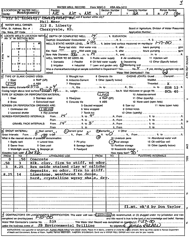
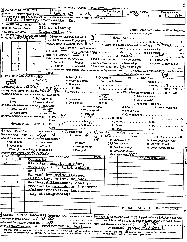
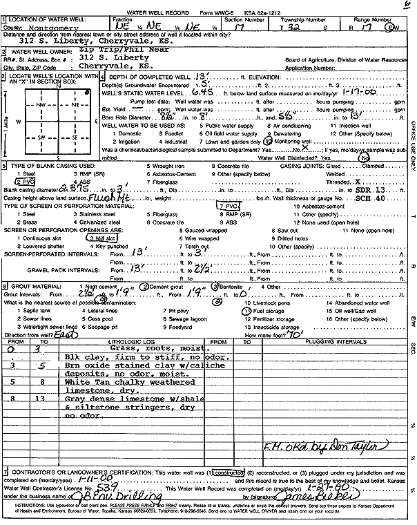
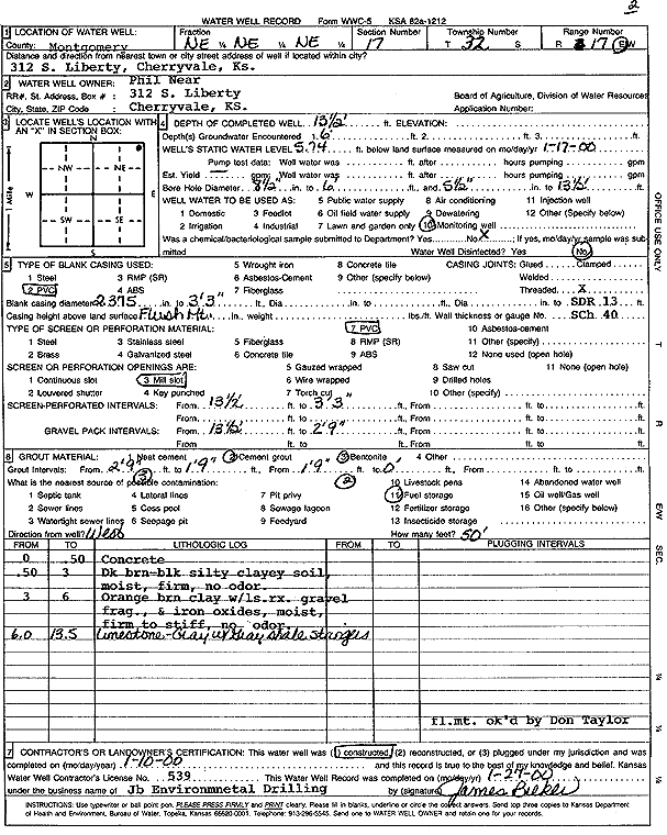
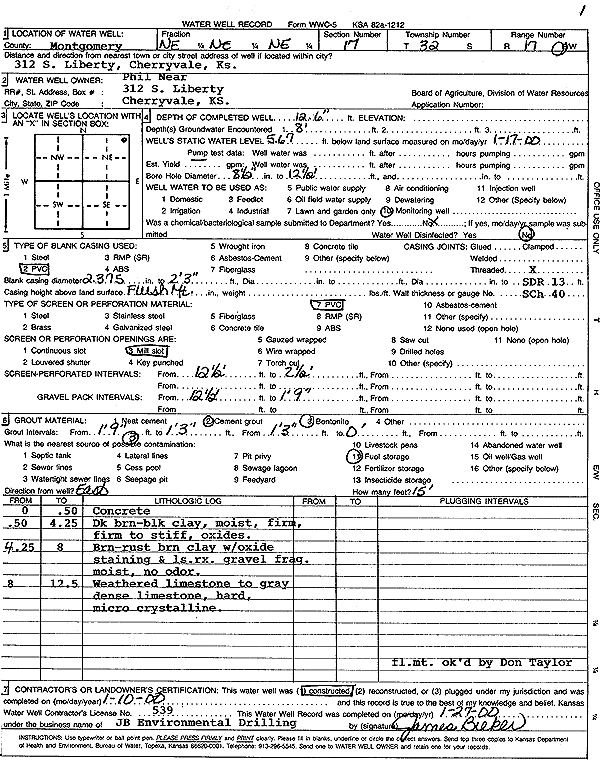
T32S, R17E, Sec. 17 NE NE NE |
Near, Phil | 14 ft. | 6.95 ft. | Monitoring well/observation/piezometer | MW 4 | Constructed | 10-Jan-2000 | Scan | |
|
T32S, R17E, Sec. 17 NE NE NE |
Near, Phil | 14 ft. | 3.41 ft. | Monitoring well/observation/piezometer | MW 3 | Constructed | 10-Jan-2000 | Scan | |
|
T32S, R17E, Sec. 17 NE NE NE |
Near, Phil | 13 ft. | 6.45 ft. | Monitoring well/observation/piezometer | MW 6 | Constructed | 11-Jan-2000 | Scan | |
|
T32S, R17E, Sec. 17 NE NE NE |
Near, Phil | 13.5 ft. | 5.74 ft. | Monitoring well/observation/piezometer | MW 2 | Constructed | 10-Jan-2000 | Scan | |
|
T32S, R17E, Sec. 17 NE NE NE |
Near, Phil | 12.5 ft. | 5.67 ft. | Monitoring well/observation/piezometer | MW 1 | Constructed | 10-Jan-2000 | Scan | |
|
T32S, R17E, Sec. 18 SE SE SE |
Cretcher, Fuller | 100 ft. | 15.5 ft. | .75 gpm. | Domestic | Constructed | 23-Dec-1980 | ||
|
T32S, R17E, Sec. 18 SE SE SE |
Cretcher, Fuller and Dody | 15 ft. | 12 ft. | Domestic | Plugged | 24-Aug-1992 | |||
|
T32S, R17E, Sec. 18 NE NE SE |
Foreman, Wayne | 94 ft. | 20 ft. | 1.5 gpm. | Domestic | Constructed | 04-May-1981 | ||
|
T32S, R17E, Sec. 19 NE NE NW |
Cretcher, Lawrence R. | 140 ft. | 60 ft. | Domestic | Constructed | 28-Apr-1981 | |||
|
T32S, R17E, Sec. 20 NW SW NE |
Williams, Jason | 132 ft. | 40 ft. | 7 gpm. | Domestic, Lawn and Garden | Constructed | 18-Jul-2022 |
KOLAR |
|
|
T32S, R17E, Sec. 21 NW NW NW |
Coats, David | 65 ft. | 12 ft. | 1 gpm. | Domestic | Constructed | 28-Apr-1977 | ||
|
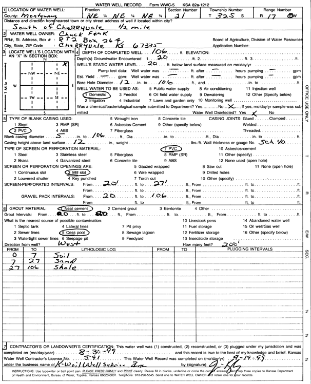
T32S, R17E, Sec. 21 NE NE NE |
Fink, Chuck | 106 ft. | 20 ft. | Domestic | Constructed | 30-Aug-1999 | Scan | ||
|
T32S, R17E, Sec. 21 NW NW NW |
Line, Eugine F. | 65 ft. | 10 ft. | 1 gpm. | Domestic | Constructed | 20-Apr-1977 | ||
|
T32S, R17E, Sec. 27 NE |
Fink, Charles Jeff | 2 ft. | Feedlot | Plugged | 23-Feb-1998 | ||||
|
T32S, R17E, Sec. 28 SE SE SE |
Housel, Charles | 100 ft. | 15 ft. | .25 gpm. | Domestic | Constructed | 20-Mar-1983 | ||
|
T32S, R17E, Sec. 30 NE SW NE |
Crawford, Howard | 82 ft. | 17.5 ft. | .5 gpm. | Domestic | Constructed | 29-Sep-1980 | ||
|
T32S, R17E, Sec. 30 NE NE NE |
Wicher, Boyd | 100 ft. | 35 ft. | Domestic | Constructed | 17-Dec-1982 | |||
|
T32S, R17E, Sec. 31 SW SW SW NE |
Resource Recovery Land Fill | 29.5 ft. | 10 ft. | Monitoring well/observation/piezometer | B-7BS | Plugged | 17-Sep-2019 |
KOLAR |
|
|
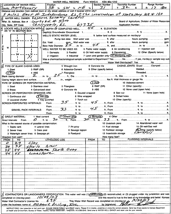
T32S, R17E, Sec. 31 SE SW NE |
Resource Recovery Landfill | 45 ft. | Monitoring well/observation/piezometer | Constructed | 29-Oct-2003 | Scan | |||
|
T32S, R17E, Sec. 31 SE SW NE |
Resource Recovery Landfill | 30 ft. | Monitoring well/observation/piezometer | Constructed | 09-Aug-2004 | ||||
|
T32S, R17E, Sec. 31 SE SW NE |
Resource Recovery Landfill | 30 ft. | Monitoring well/observation/piezometer | Constructed | 09-Aug-2004 | ||||
|
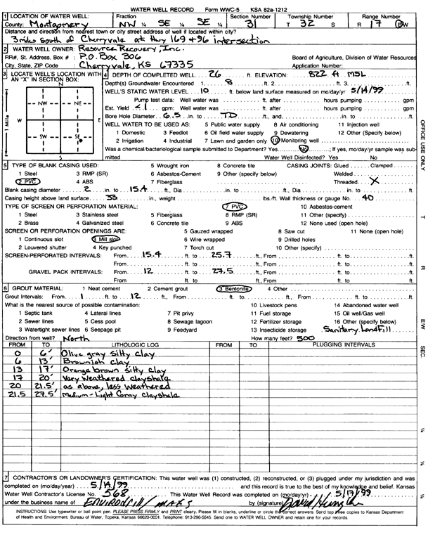
T32S, R17E, Sec. 31 SE NW NW |
Resource Recovery, Inc. | 85 ft. | Monitoring well/observation/piezometer | MW 4 | Constructed | 28-Apr-1993 | |||
|
T32S, R17E, Sec. 31 NE NE SE |
Resource Recovery, Inc. | 16.5 ft. | Monitoring well/observation/piezometer | MW 1 | Constructed | 27-May-1998 | |||
|
T32S, R17E, Sec. 31 NE SW SE |
Resource Recovery, Inc. | 23.5 ft. | 5.18 ft. | Monitoring well/observation/piezometer | MW 4 | Constructed | 27-May-1998 | ||
|
T32S, R17E, Sec. 31 NW SE NE |
Resource Recovery, Inc. | 22.5 ft. | Monitoring well/observation/piezometer | MW 9 | Constructed | 28-May-1998 | |||
|
T32S, R17E, Sec. 31 SW SW NE |
Resource Recovery, Inc. | 34 ft. | 11.1 ft. | Monitoring well/observation/piezometer | MW 7 | Constructed | 27-May-1998 | ||
|
T32S, R17E, Sec. 31 SW NW SE |
Resource Recovery, Inc. | 17.5 ft. | Monitoring well/observation/piezometer | MW 5 | Constructed | 27-May-1998 | |||
|
T32S, R17E, Sec. 31 SW NW SE |
Resource Recovery, Inc. | 21.3 ft. | Monitoring well/observation/piezometer | MW 6 | Constructed | 27-May-1998 | |||
|
T32S, R17E, Sec. 31 NE SW SE |
Resource Recovery, Inc. | 23.9 ft. | 6.6 ft. | Monitoring well/observation/piezometer | MW 3 | Constructed | 26-May-1998 | ||
|
T32S, R17E, Sec. 31 NE NE SE |
Resource Recovery, Inc. | 55 ft. | Monitoring well/observation/piezometer | MW 1 | Constructed | 28-Apr-1993 | |||
|
T32S, R17E, Sec. 31 SE NE SE |
Resource Recovery, Inc. | 20.5 ft. | 5.3 ft. | Monitoring well/observation/piezometer | MW 2 | Constructed | 22-May-1998 | ||
|
T32S, R17E, Sec. 31 NW SE SE |
Resource Recovery, Inc. | 26 ft. | 10 ft. | Monitoring well/observation/piezometer | Constructed | 14-May-1999 | Scan | ||
|
T32S, R17E, Sec. 31 NW SW NE |
Resource Recovery, Inc. | 16.5 ft. | 10.6 ft. | Monitoring well/observation/piezometer | MW 8 | Constructed | 27-May-1998 | ||
|
T32S, R17E, Sec. 31 NW NW SE |
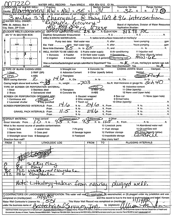
Resource Recovery, Inc. | 24.6 ft. | Monitoring well/observation/piezometer | MW 6 R | Constructed | 09-Oct-2000 | Scan | ||
| View page: < Prev || 11 || 12 || 13 || 14 || 15 || 16 || 17 || 18 || 19 || 20 || Next > | |||||||||