Select location of well to view details.
Click on column heading to sort.
|
|
|
County: Morton Select location of well to view details. Click on column heading to sort. |
|
|
|
| View page: < Prev || 11 || 12 || 13 || 14 || 15 || 16 || 17 || 18 || 19 || 20 || Next > | |||||||||
| T-R-S | Owner | Well Depth Ascend. Desc. |
Static Water Level Ascend. Desc. |
Est. Yield Ascend. Desc. |
Well Use | Other ID | Action Taken | Completion Date Ascend. Desc. |
Scan? |
|
T33S, R43W, Sec. 18 NE SW SW NW |
Kinder Morgan | 117 ft. | 105 ft. | Monitoring well/observation/piezometer | MC MW 15 | Constructed | 21-Jun-2017 | ||
|
T33S, R43W, Sec. 19 SW SW SE |
Cimarron National Grassland | 110 ft. | (unstated)/abandoned | Plugged | 09-Oct-1997 | ||||
|
T33S, R43W, Sec. 21 SW NE NE |
Oxy USA, Inc. | 260 ft. | 100 ft. | 100 gpm. | Oil Field Water Supply | Bradshaw A 2 | Constructed | 18-Apr-1998 | |
|
T33S, R43W, Sec. 24 SW NE SE |
Cities Service Co. | 240 ft. | 105 ft. | 80 gpm. | Oil Field Water Supply | Constructed | 14-Dec-1978 | ||
|
T33S, R43W, Sec. 25 C SE |
U.S. Forest Service | 180 ft. | 122 ft. | 10 gpm. | Domestic, Livestock | Well 22 | Constructed | 15-Jun-1978 | |
|
T33S, R43W, Sec. 25 C SE SE |
U.S. Forest Service | 152 ft. | 125 ft. | Domestic, Livestock | A-14 | Plugged | 25-Sep-1992 | ||
|
T33S, R43W, Sec. 26 NE NW NE |
U.S. Forest Service | 180 ft. | 110 ft. | 35 gpm. | Domestic, Livestock | Well 21 | Constructed | 15-Jun-1978 | |
|
T33S, R43W, Sec. 27 NW SE SW |
Smith, Bob | 260 ft. | 123 ft. | 25 gpm. | Domestic | Constructed | 30-Mar-2000 | Scan | |
|
T33S, R43W, Sec. 27 NE NE SW |
Witcher, Dan | 37 ft. | 35 ft. | Domestic | Plugged | 12-Jan-1995 | |||
|
T33S, R43W, Sec. 29 SE NW |
Ryman, Louis | 460 ft. | 116 ft. | 370 gpm. | Irrigation | Constructed | 27-Oct-1975 | ||
|
T33S, R43W, Sec. 29 NW SE NW |
Ryman, Louis | 450 ft. | 116 ft. | 370 gpm. | Irrigation | Constructed | 15-Mar-1976 | ||
|
T33S, R43W, Sec. 31 C SW |
Ferguson Oil and Gas Co. | 280 ft. | 163 ft. | 60 gpm. | Oil Field Water Supply | Jackson 1 | Constructed | 05-Jul-1980 | |
|
T33S, R43W, Sec. 34 SE NE NE |
Fletcher, W.D. | 190 ft. | 126 ft. | 25 gpm. | Domestic | Constructed | 28-Oct-1975 | ||
|
T33S, R43W, Sec. 34 NW NE NW |
U.S. Forest Service | 200 ft. | 128 ft. | 10 gpm. | Domestic, Livestock | Well 20 | Constructed | 16-Jun-1978 | |
|
T34S, R39W, Sec. 4 NE SW NE |
Gabbert and Jones | 270 ft. | 200 ft. | 80 gpm. | Oil Field Water Supply | Dole 1 | Constructed | 17-Mar-1989 | |
|
T34S, R39W, Sec. 5 NE NE SW |
U.S. Forest Service | 240 ft. | 120 ft. | 40 gpm. | Domestic, Livestock | Well 25 | Constructed | 22-Jun-1978 | |
|
T34S, R39W, Sec. 7 C |
Cimarron National Grassland | 200 ft. | 150 ft. | 40 gpm. | Domestic, Livestock | Constructed | 21-Apr-1983 | ||
|
T34S, R39W, Sec. 7 C NE SW |
U.S. Forest Service | 200 ft. | 150 ft. | Domestic, Livestock | B-4 | Plugged | 14-Oct-1992 | ||
|
T34S, R39W, Sec. 8 C NE SW |
Mobil Oil Corp./Wesley Bressler | 320 ft. | 156 ft. | 60 gpm. | Oil Field Water Supply | F.A. Thompson 1 | Constructed | 23-Mar-1984 | |
|
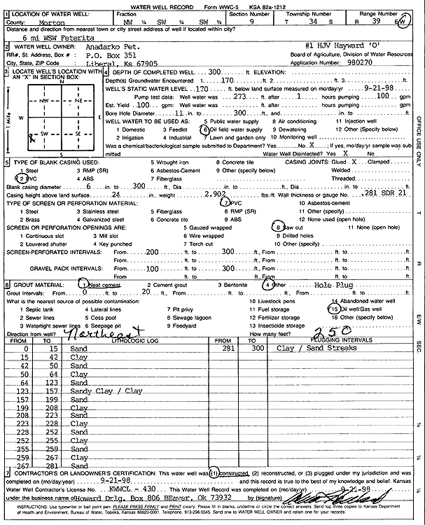
T34S, R39W, Sec. 9 NW SW SW |
Anadarko Petroleum Corp. | 300 ft. | 170 ft. | 100 gpm. | Oil Field Water Supply | HJV Hayward O-1 | Constructed | 21-Sep-1998 | Scan |
|
T34S, R39W, Sec. 9 C NE |
U.S. Forest Service | 116 ft. | Domestic, Livestock | A-13 | Plugged | 07-Oct-1992 | |||
|
T34S, R39W, Sec. 16 SW SE SW SW |
Cimarron National Grasslands | 460 ft. | 204 ft. | 50 gpm. | Domestic, Livestock | Constructed | 18-Nov-2019 | ||
|
T34S, R39W, Sec. 16 SE SE NE |
Gabbert and Jones | 320 ft. | 200 ft. | 70 gpm. | Oil Field Water Supply | McCalp 1 | Constructed | 05-Dec-1988 | |
|
T34S, R39W, Sec. 16 SE SE NE |
Gabbert and Jones | 320 ft. | 200 ft. | Oil Field Water Supply | McCalp 1 | Plugged | 29-Dec-1988 | ||
|
T34S, R39W, Sec. 17 C NE NE |
Cimarron National Grassland | 176 ft. | 171 ft. | Domestic, Livestock | Plugged | 25-Oct-1996 | |||
|
T34S, R39W, Sec. 17 SE SW SE |
Hinch, Charles F. | 475 ft. | 188 ft. | Irrigation | Constructed | 25-Feb-1992 | |||
|
T34S, R39W, Sec. 17 NE NE NE |
U.S. Forest Service | 265 ft. | 170 ft. | 25 gpm. | Domestic | Well 5 | Constructed | 04-Aug-1995 | |
|
T34S, R39W, Sec. 18 NW NW NW |
Cimarron National Grassland | 95 ft. | (unstated)/abandoned | Plugged | 22-Oct-1997 | ||||
|
T34S, R39W, Sec. 18 SE NE SE |
Randle, Randy | 359 ft. | 107 ft. | 25 gpm. | Domestic | Constructed | 14-Dec-1994 | ||
|
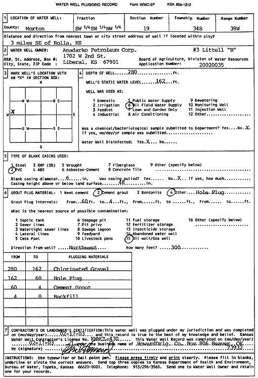
T34S, R39W, Sec. 19 SW SW NW |
Anadarko Petroleum Corp. | 280 ft. | 162 ft. | Oil Field Water Supply | Littell B-3 | Plugged | 17-Feb-2003 | Scan | |
|
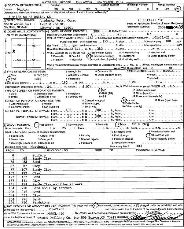
T34S, R39W, Sec. 19 SW SW NW |
Anadarko Petroleum Corp. | 280 ft. | 162 ft. | 100 gpm. | Oil Field Water Supply | Littell B-3 | Constructed | 21-Jan-2002 | Scan |
|
T34S, R39W, Sec. 19 SE SE SW |
Littell, Clark | 480 ft. | 180 ft. | Irrigation | Constructed | 10-Nov-1997 | |||
|
T34S, R39W, Sec. 20 SW NE SW |
Gabbert and Jones | 420 ft. | 210 ft. | 65 gpm. | Oil Field Water Supply | Bennett 1 | Constructed | 06-Dec-1988 | |
|
T34S, R39W, Sec. 21 NE SW SE |
Light, Bill | 506 ft. | 141 ft. | Irrigation | Constructed | 21-May-1976 | |||
|
T34S, R39W, Sec. 21 C NE |
U.S. Forest Service | 220 ft. | 150 ft. | 30 gpm. | Domestic, Livestock | Well 27 | Constructed | 27-Jun-1978 | |
|
T34S, R39W, Sec. 28 SW SW SE |
Easterwood, Dale | 525 ft. | 193 ft. | Irrigation | Constructed | 07-May-1996 | |||
|
T34S, R39W, Sec. 28 SE NE NE |
Light, W.J. | 540 ft. | 195 ft. | Irrigation | Constructed | 05-May-1998 | |||
|
T34S, R39W, Sec. 29 NE NE NE |
Hinch, Charles | 533 ft. | 202 ft. | Irrigation | Constructed | 10-Apr-1992 | |||
|
T34S, R39W, Sec. 29 NE NE SE |
Hinch, Charlie | 208 ft. | Domestic, Livestock | Plugged | 05-Oct-2001 | Scan | |||
|
T34S, R39W, Sec. 31 SE SE SW |
Brummett, Ronald | 340 ft. | Domestic | Constructed | 06-Dec-1996 | ||||
|
T34S, R39W, Sec. 31 SE SE NW |
Johnson, Wayne | 490 ft. | 228 ft. | Irrigation | Constructed | 16-Feb-2004 | Scan | ||
|
T34S, R39W, Sec. 31 NW NW SE |
Murfin Drilling/Albert Clinesmith | 300 ft. | 222 ft. | Oil Field Water Supply | Constructed | 24-Mar-1995 | |||
|
T34S, R39W, Sec. 31 NW NW SE |
Murfin Drilling/Albert Clinesmith | 300 ft. | 222 ft. | Oil Field Water Supply | Plugged | 01-Jul-1995 | |||
|
T34S, R39W, Sec. 32 NE NE SE |
Easterwood, Dale | 500 ft. | Test hole/well | Constructed | 08-Jun-1997 | ||||
|
T34S, R39W, Sec. 32 SE SE |
Easterwood, Dale | 331 ft. | 180 ft. | Domestic | Constructed | 08-Apr-1985 | |||
|
T34S, R39W, Sec. 32 NE NE NE |
Easterwood, Dale | 503 ft. | 204 ft. | 1319 gpm. | Irrigation | Constructed | 18-Apr-1998 | ||
|
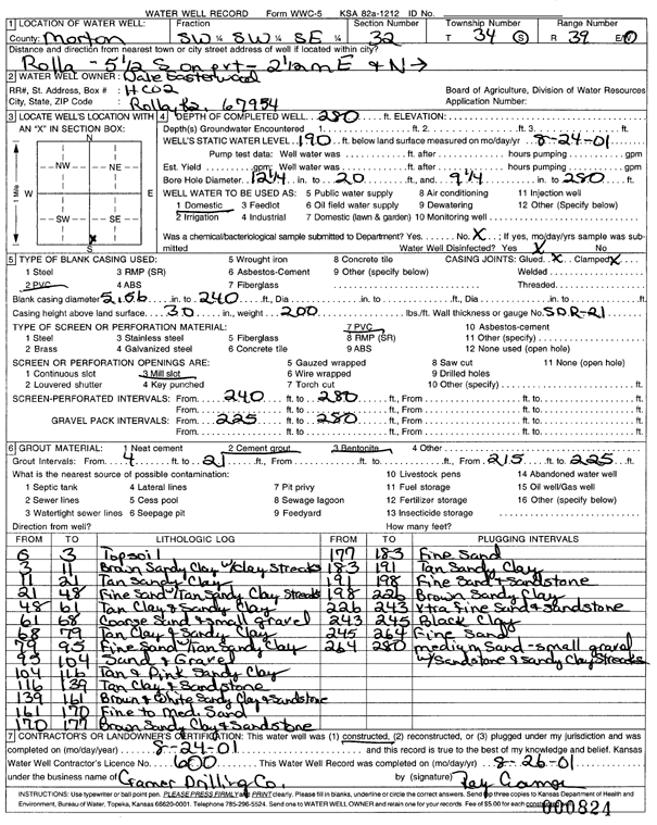
T34S, R39W, Sec. 32 SW SW SE |
Easterwood, Dale | 280 ft. | 190 ft. | Domestic | Constructed | 24-Aug-2001 | Scan | ||
|
T34S, R39W, Sec. 32 SW NW SE |
Easterwood, Elizabeth | 490 ft. | 250 ft. | Irrigation | Constructed | 23-May-2007 | |||
|
T34S, R39W, Sec. 32 SW SW NW |
Johnson, Kyle | 484 ft. | 280 ft. | 50 gpm. | Domestic, Livestock | Constructed | 29-Oct-2025 |
KOLAR |
|
|
T34S, R39W, Sec. 32 NE NE NW |
Littell, Clark | 480 ft. | 156 ft. | Irrigation | Constructed | 17-Nov-1995 | |||
| View page: < Prev || 11 || 12 || 13 || 14 || 15 || 16 || 17 || 18 || 19 || 20 || Next > | |||||||||