Select location of well to view details.
Click on column heading to sort.
|
|
|
County: Morton Select location of well to view details. Click on column heading to sort. |
|
|
|
| View page: < Prev || 21 || 22 || 23 || 24 || 25 | |||||||||
| T-R-S | Owner | Well Depth Ascend. Desc. |
Static Water Level Ascend. Desc. |
Est. Yield Ascend. Desc. |
Well Use | Other ID | Action Taken | Completion Date Ascend. Desc. |
Scan? |
|
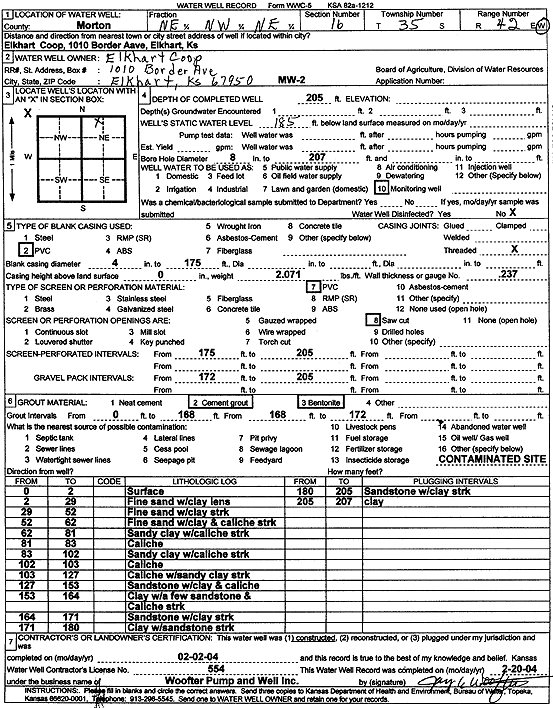
T35S, R42W, Sec. 16 NE NW NE |
Elkhart Coop | 205 ft. | 185 ft. | Monitoring well/observation/piezometer | MW 2 | Constructed | 02-Feb-2004 | Scan | |
|
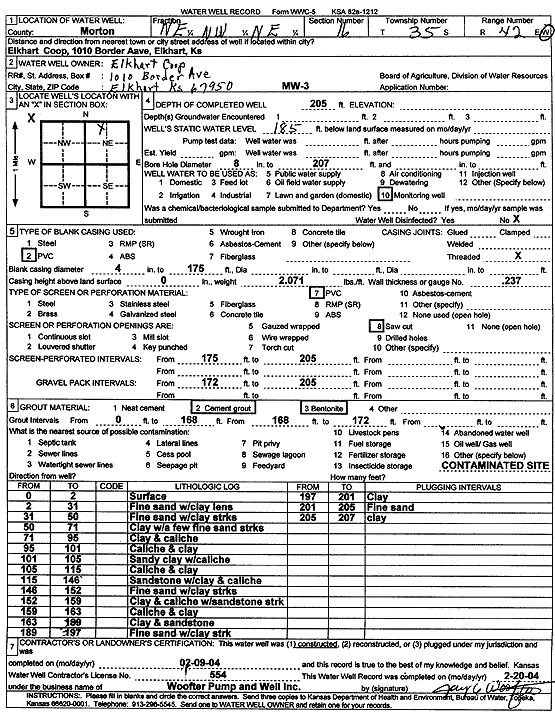
T35S, R42W, Sec. 16 NE NW NE |
Elkhart Coop | 205 ft. | 185 ft. | Monitoring well/observation/piezometer | MW 3 | Constructed | 09-Feb-2004 | Scan | |
|
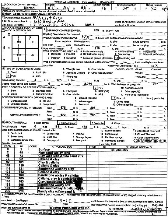
T35S, R42W, Sec. 16 NE NW NE |
Elkhart Coop | 205 ft. | 185 ft. | Monitoring well/observation/piezometer | MW 5 | Constructed | 03-Feb-2004 | Scan | |
|
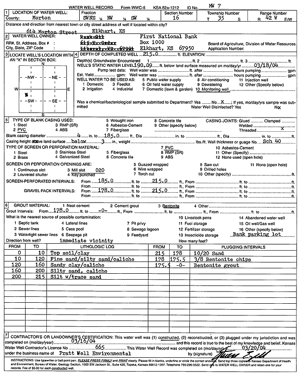
T35S, R42W, Sec. 16 SW NE NW SW |
First National Bank | 215 ft. | 190.09 ft. | Monitoring well/observation/piezometer | MW 7 | Constructed | 16-Mar-2004 | Scan | |
|
T35S, R42W, Sec. 16 NE NE NW NW |
KDHE | 238 ft. | 196 ft. | Monitoring well/observation/piezometer | RA MW 3 | Constructed | 25-Jun-2020 |
KOLAR |
|
|
T35S, R42W, Sec. 16 NE NE NW NW |
KDHE | 241 ft. | 204.81 ft. | Monitoring well/observation/piezometer | RA MW 1 | Constructed | 25-Jun-2020 |
KOLAR |
|
|
T35S, R42W, Sec. 16 NW NE NW NW |
KDHE | 241 ft. | 210.66 ft. | Monitoring well/observation/piezometer | RA MW 2 | Constructed | 25-Jun-2020 |
KOLAR |
|
|
T35S, R42W, Sec. 16 NE NE SW NW |
KDHE | 240 ft. | 201.1 ft. | Monitoring well/observation/piezometer | MW 5 | Constructed | 15-Jul-2020 |
KOLAR |
|
|
T35S, R42W, Sec. 16 NW SW NW NW |
KDHE | 237 ft. | 204.02 ft. | Monitoring well/observation/piezometer | MW 2 | Constructed | 15-Jul-2020 |
KOLAR |
|
|
T35S, R42W, Sec. 16 SW SW NE NW |
KDHE | 237 ft. | 202 ft. | Monitoring well/observation/piezometer | RA MW 4 | Constructed | 24-Jun-2020 |
KOLAR |
|
|
T35S, R42W, Sec. 16 SW NE NW NW |
KDHE | 238 ft. | 203.83 ft. | Monitoring well/observation/piezometer | RA MW 5 | Constructed | 25-Jun-2020 |
KOLAR |
|
|
T35S, R42W, Sec. 16 NW SW NW NW |
KDHE | 238 ft. | 204.73 ft. | Monitoring well/observation/piezometer | MW 1 | Constructed | 15-Jul-2020 |
KOLAR |
|
|
T35S, R42W, Sec. 16 NE SW NW NW |
KDHE | 237 ft. | 198 ft. | Monitoring well/observation/piezometer | MW 3 | Constructed | 15-Jul-2020 |
KOLAR |
|
|
T35S, R42W, Sec. 16 NW SE NW NW |
KDHE | 238 ft. | 205.91 ft. | Monitoring well/observation/piezometer | MW 4 | Constructed | 15-Jul-2020 |
KOLAR |
|
|
T35S, R42W, Sec. 16 SW NE SW NE |
KDHE-BER | 211.12 ft. | 205.4 ft. | Monitoring well/observation/piezometer | MW 2 | Plugged | 10-Mar-2016 | ||
|
T35S, R42W, Sec. 16 SW NE SW NE |
KDHE-BER | 215 ft. | 208.4 ft. | Monitoring well/observation/piezometer | MW 1 | Constructed | 28-Aug-2014 | ||
|
T35S, R42W, Sec. 16 SE NE SW NE |
KDHE-BER | 215 ft. | 206.8 ft. | Monitoring well/observation/piezometer | MW 3 | Constructed | 27-Aug-2014 | ||
|
T35S, R42W, Sec. 16 SE NE SW NE |
KDHE-BER | 215.6 ft. | 208.13 ft. | Monitoring well/observation/piezometer | MW 3 | Plugged | 10-Mar-2016 | ||
|
T35S, R42W, Sec. 16 SW NE SW NE |
KDHE-BER | 216.65 ft. | 209.64 ft. | Monitoring well/observation/piezometer | MW 1 | Plugged | 09-Mar-2016 | ||
|
T35S, R42W, Sec. 16 SW NE SW NE |
KDHE-BER | 210 ft. | 210.1 ft. | Monitoring well/observation/piezometer | MW 2 | Constructed | 27-Aug-2014 | ||
|
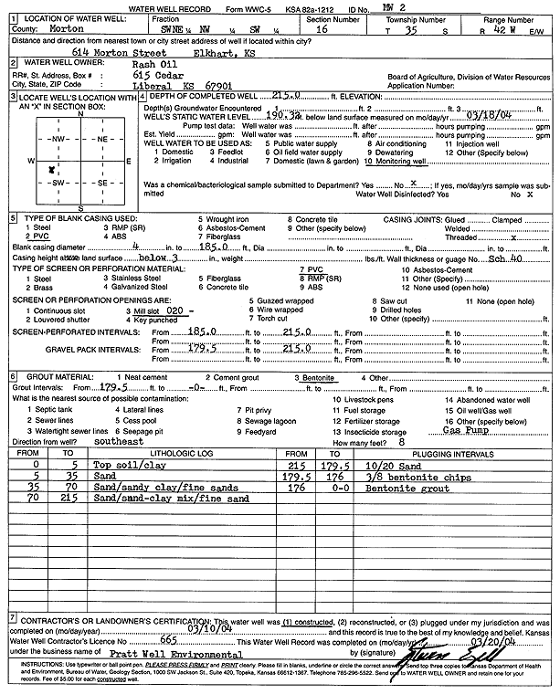
T35S, R42W, Sec. 16 SW NE NW SW |
Rash Oil | 215 ft. | 190.32 ft. | Monitoring well/observation/piezometer | MW 2 | Constructed | 10-Mar-2004 | Scan | |
|
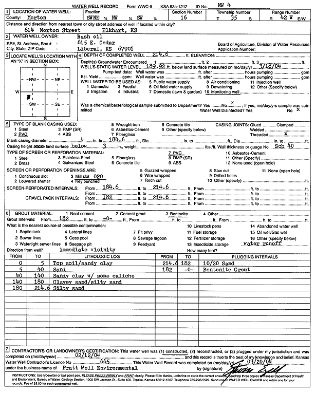
T35S, R42W, Sec. 16 SW NE NW SW |
Rash Oil | 214.6 ft. | 189.92 ft. | Monitoring well/observation/piezometer | MW 4 | Constructed | 12-Feb-2004 | Scan | |
|
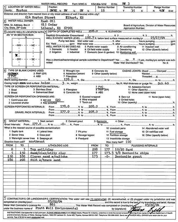
T35S, R42W, Sec. 16 SW NE NW SW |
Rash Oil | 208 ft. | 188.7 ft. | Monitoring well/observation/piezometer | MW 3 | Constructed | 02-Mar-2004 | Scan | |
|
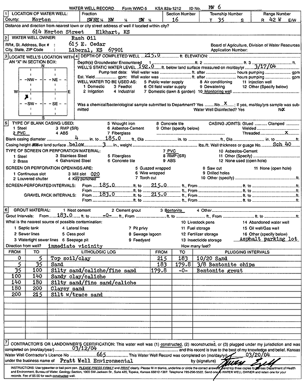
T35S, R42W, Sec. 16 SW NE NW SW |
Rash Oil | 215 ft. | 192 ft. | Monitoring well/observation/piezometer | MW 6 | Constructed | 12-Mar-2004 | Scan | |
|
T35S, R42W, Sec. 16 SW NE NW SW |
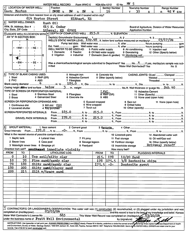
Rash Oil | 215 ft. | 189.48 ft. | Monitoring well/observation/piezometer | MW 5 | Constructed | 05-Mar-2004 | Scan | |
|
T35S, R42W, Sec. 16 SW NE NW SW |
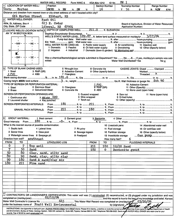
Rash Oil | 211 ft. | 189.87 ft. | Monitoring well/observation/piezometer | MW 1 | Constructed | 10-Feb-2004 | Scan | |
|
T35S, R42W, Sec. 16 SW NE NW SW |
Rash, Don | 210 ft. | 192.16 ft. | Monitoring well/observation/piezometer | MW 12 | Constructed | 16-Feb-2005 | ||
|
T35S, R42W, Sec. 16 NE NW SW |
Rash, Don | 212 ft. | 197 ft. | 2 gpm. | Monitoring well/observation/piezometer | MW 25 | Constructed | 29-Aug-2006 | |
|
T35S, R42W, Sec. 16 NE NW SW |
Rash, Don | 210 ft. | 190.2 ft. | 2 gpm. | Monitoring well/observation/piezometer | MW 27 | Constructed | 05-Sep-2006 | |
|
T35S, R42W, Sec. 16 NE NW SW |
Rash, Don | 210 ft. | 188.2 ft. | 2 gpm. | Monitoring well/observation/piezometer | MW 28 | Constructed | 06-Sep-2006 | |
|
T35S, R42W, Sec. 16 SW NE NW SW |
Rash, Don | 210 ft. | 186.81 ft. | Monitoring well/observation/piezometer | MW 22 | Constructed | 07-Feb-2006 | ||
|
T35S, R42W, Sec. 16 SW NE NW SW |
Rash, Don | 214 ft. | 187.75 ft. | Monitoring well/observation/piezometer | MW 15 | Constructed | 29-Aug-2005 | ||
|
T35S, R42W, Sec. 16 SW NE NW SW |
Rash, Don | 210 ft. | 185.26 ft. | Monitoring well/observation/piezometer | MW 21 | Constructed | 06-Feb-2006 | ||
|
T35S, R42W, Sec. 16 SW NE NW SW |
Rash, Don | 208.5 ft. | 185.7 ft. | Monitoring well/observation/piezometer | MW 17 | Constructed | 01-Sep-2005 | ||
|
T35S, R42W, Sec. 16 SW NE NW SW |
Rash, Don | 210 ft. | 185.9 ft. | Monitoring well/observation/piezometer | MW 16 | Constructed | 31-Aug-2005 | ||
|
T35S, R42W, Sec. 16 SW NE NW SW |
Rash, Don | 210 ft. | Monitoring well/observation/piezometer | MW 20 | Constructed | 07-Sep-2005 | |||
|
T35S, R42W, Sec. 16 SW NE NW SW |
Rash, Don | 213 ft. | Monitoring well/observation/piezometer | MW 19 | Constructed | 06-Sep-2005 | |||
|
T35S, R42W, Sec. 16 NE NW SW |
Rash, Don | 210 ft. | 185.1 ft. | 2 gpm. | Monitoring well/observation/piezometer | MW 30 | Constructed | 07-Sep-2006 | |
|
T35S, R42W, Sec. 16 NE NW SW |
Rash, Don | 210 ft. | 186.3 ft. | 2 gpm. | Monitoring well/observation/piezometer | MW 29 | Constructed | 07-Sep-2006 | |
|
T35S, R42W, Sec. 16 NE NW SW |
Rash, Don | 210 ft. | 189.6 ft. | 2 gpm. | Monitoring well/observation/piezometer | MW 26 | Constructed | 31-Aug-2006 | |
|
T35S, R42W, Sec. 16 SW NE NW SW |
Rash, Don | 210 ft. | 193.55 ft. | Monitoring well/observation/piezometer | MW 24 | Constructed | 09-Feb-2006 | ||
|
T35S, R42W, Sec. 16 SW NE NW SW |
Rash, Don | 212 ft. | 192.65 ft. | Monitoring well/observation/piezometer | MW 10 | Constructed | 22-Feb-2005 | ||
|
T35S, R42W, Sec. 16 SW NE NW SW |
Rash, Don | 215 ft. | 197.8 ft. | Monitoring well/observation/piezometer | MW 13 | Constructed | 21-Feb-2005 | ||
|
T35S, R42W, Sec. 16 SW NE NW SW |
Rash, Don | 209.5 ft. | 189.61 ft. | Monitoring well/observation/piezometer | MW 14 | Constructed | 23-Feb-2005 | ||
|
T35S, R42W, Sec. 16 SW NE NW SW |
Rash, Don | 212 ft. | 194.24 ft. | Monitoring well/observation/piezometer | MW 9 | Constructed | 22-Feb-2005 | ||
|
T35S, R42W, Sec. 16 SW NE NW SW |
Rash, Don | 212 ft. | 193.6 ft. | Monitoring well/observation/piezometer | MW 11 | Constructed | 17-Feb-2005 | ||
|
T35S, R42W, Sec. 16 SW NE NW SW |
Rash, Don | 214 ft. | 196.04 ft. | Monitoring well/observation/piezometer | MW 8 | Constructed | 17-Feb-2005 | ||
|
T35S, R42W, Sec. 16 SW NE NW SW |
Rash, Don | 210 ft. | 191.02 ft. | Monitoring well/observation/piezometer | MW 23 | Constructed | 08-Feb-2006 | ||
|
T35S, R42W, Sec. 16 SW NE NW SW |
Rash, Don | 212 ft. | 194.29 ft. | Monitoring well/observation/piezometer | MW 18 | Constructed | 02-Sep-2005 | ||
|
T35S, R42W, Sec. 16 SE NW SW |
Spencer Distributing | 209.68 ft. | 187.03 ft. | Monitoring well/observation/piezometer | MW 1 | Plugged | 20-Sep-2006 | ||
| View page: < Prev || 21 || 22 || 23 || 24 || 25 | |||||||||