Select location of well to view details.
Click on column heading to sort.
|
|
|
County: Morton Select location of well to view details. Click on column heading to sort. |
|
|
|
| View page: 1 || 2 || 3 || 4 || 5 || 6 || 7 || 8 || 9 || 10 || Next > | |||||||||
| T-R-S | Owner | Well Depth Ascend. Desc. |
Static Water Level Ascend. Desc. |
Est. Yield Ascend. Desc. |
Well Use | Other ID | Action Taken | Completion Date Ascend. Desc. |
Scan? |
|
T33S, R41W, Sec. 3 C SE SE |
Ladd Petroleum | 300 ft. | 168 ft. | 60 gpm. | Oil Field Water Supply | Berryman-Richfield | Constructed | 11-May-1981 | |
|
T33S, R41W, Sec. 3 SE SE NW |
Ladd Petroleum | 200 ft. | 120 ft. | 60 gpm. | Oil Field Water Supply | Berryman-Richfield 11-2 | Constructed | 12-Jul-1984 | |
|
T33S, R41W, Sec. 3 C NW NE |
Ladd Petroleum | 380 ft. | 145 ft. | 60 gpm. | Oil Field Water Supply | Berryman-Richfield 12-3 | Constructed | 04-Aug-1981 | |
|
T33S, R41W, Sec. 3 C NW SE |
Ladd Petroleum/Robert Davis | 300 ft. | 130 ft. | 60 gpm. | Oil Field Water Supply | Berryman-Richfield 14-3 | Constructed | 18-Apr-1983 | |
|
T33S, R41W, Sec. 3 SE SE NW |
Nelson, Seth | 661 ft. | 144 ft. | Irrigation | 5-24 | Constructed | 11-Jul-2024 |
KOLAR |
|
|
T33S, R41W, Sec. 3 NE NE NE |
Nelson, Seth | 638 ft. | 160 ft. | Irrigation | 4-24 | Constructed | 09-Jul-2024 |
KOLAR |
|
|
T33S, R41W, Sec. 4 NW SE NW NE |
Nelson, Seth | 442 ft. | 99 ft. | 400 gpm. | Irrigation | Constructed | 27-May-2010 | ||
|
T33S, R41W, Sec. 4 SW SW NW SW |
Robert W. Davis Trust | 427 ft. | 134 ft. | 354 gpm. | Irrigation | Constructed | 24-Sep-2018 |
KOLAR |
|
|
T33S, R41W, Sec. 7 S2 SE |
Lowery Lease Management | 280 ft. | 108 ft. | 60 gpm. | Oil Field Water Supply | Irene Hitchcock 1 | Constructed | 24-Apr-1981 | |
|
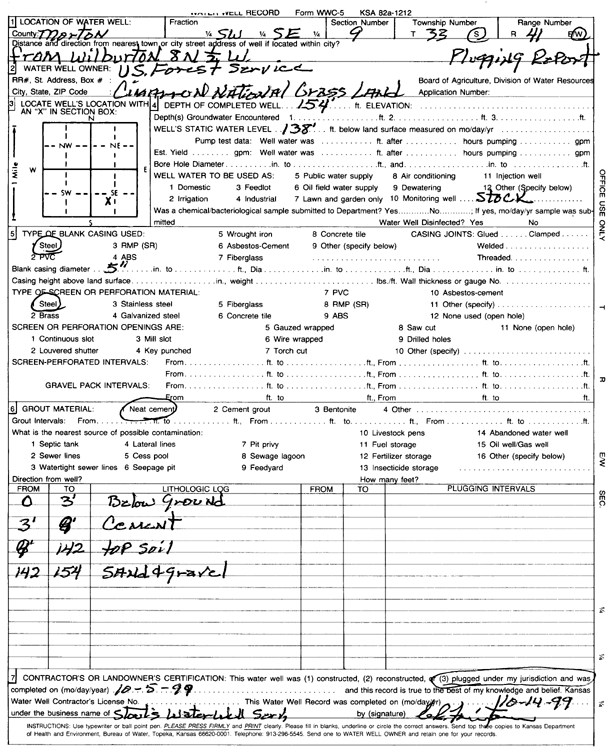
T33S, R41W, Sec. 9 SW SE |
Cimarron National Grassland | 154 ft. | 138 ft. | Domestic, Livestock | Well 2 | Plugged | 05-Oct-1999 | Scan | |
|
T33S, R41W, Sec. 9 SE SE NE |
Johnson, Betty | 260 ft. | 125 ft. | Domestic | Constructed | 20-Jun-1981 | |||
|
T33S, R41W, Sec. 9 C NE SW |
Ladd Petroleum/Betty Johnson | 280 ft. | 115 ft. | 60 gpm. | Oil Field Water Supply | Berryman-Richfield 22-3 | Constructed | 29-Apr-1983 | |
|
T33S, R41W, Sec. 9 NW SE NE SW |
Nelson, Seth | 405 ft. | 94 ft. | 300 gpm. | Irrigation | Constructed | 18-Mar-2011 | ||
|
T33S, R41W, Sec. 9 SW SE NE |
Nelson, Seth | 403 ft. | 112 ft. | Domestic | Constructed | 23-Mar-2010 | |||
|
T33S, R41W, Sec. 10 NW NW NE |
Ladd Petroleum | 290 ft. | 170 ft. | 55 gpm. | Oil Field Water Supply | Berryman-Richfield 20-1 | Constructed | 20-Sep-1985 | |
|
T33S, R41W, Sec. 13 N2 N2 SE |
Morton County Grazing Assoc. | 90 ft. | 55 ft. | 60 gpm. | Domestic, Livestock | Constructed | 18-May-1984 | ||
|
T33S, R41W, Sec. 13 S2 SE |
Panhandle Eastern Pipeline | 35 ft. | 27 ft. | Monitoring well/observation/piezometer | Constructed | 13-Nov-1992 | |||
|
T33S, R41W, Sec. 14 SE SE SE |
Gabbert and Jones/Morton County Grazing Assoc. | 240 ft. | 75 ft. | 50 gpm. | Oil Field Water Supply | Constructed | 25-Nov-1981 | ||
|
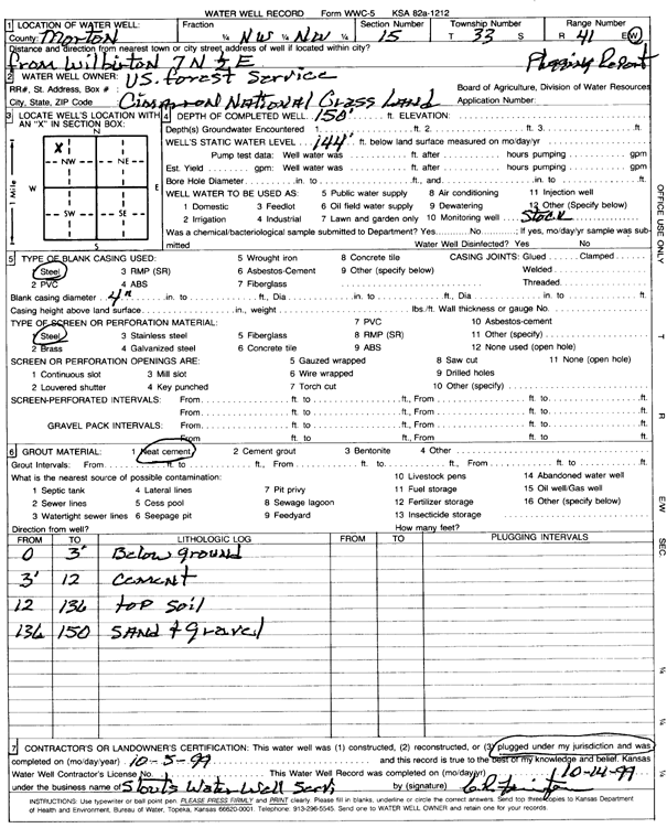
T33S, R41W, Sec. 15 NW NW |
Cimarron National Grassland | 150 ft. | 144 ft. | Domestic, Livestock | Well 3 | Plugged | 05-Oct-1999 | Scan | |
|
T33S, R41W, Sec. 15 SW SE NW |
USDA Forest Service (was EOG Resources, Inc.) | 240 ft. | 122 ft. | 70 gpm. | Domestic, changed from Oil Field Water Supply | Grassland 15-1 | Constructed | 23-Apr-2009 | |
|
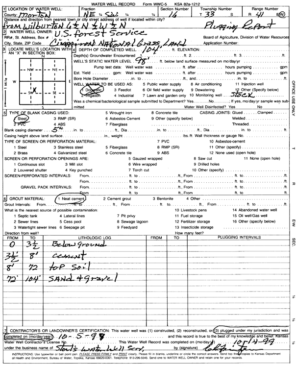
T33S, R41W, Sec. 16 NE SW |
Cimarron National Grassland | 104 ft. | 98 ft. | Domestic, Livestock | Well 9 | Plugged | 05-Oct-1999 | Scan | |
|
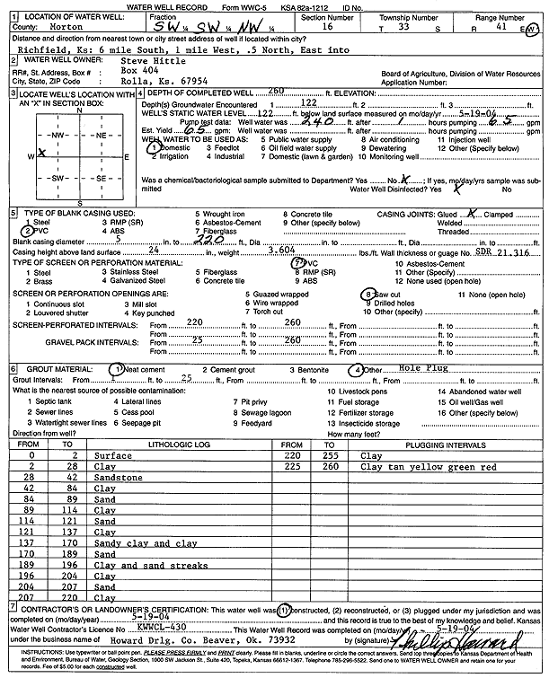
T33S, R41W, Sec. 16 SW SW NW |
Hittle, Steve | 260 ft. | 122 ft. | 65 gpm. | Domestic | Constructed | 19-May-2004 | Scan | |
|
T33S, R41W, Sec. 16 NE NE NW |
Ladd Petroleum | 398 ft. | Oil Field Water Supply | Constructed | 25-Aug-1975 | ||||
|
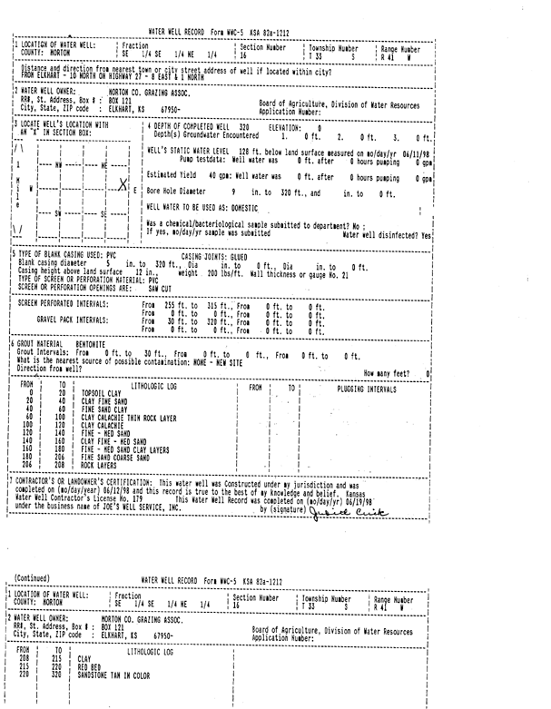
T33S, R41W, Sec. 16 SE SE NE |
Morton County Grazing Assoc. | 320 ft. | 128 ft. | 40 gpm. | Domestic | Constructed | 12-Jun-1998 | Scan | |
|
T33S, R41W, Sec. 16 NE NE NW |
TriPower Resources Inc. | 432 ft. | 156 ft. | Oil Field Water Supply | Plugged | 05-Sep-1995 | |||
|
T33S, R41W, Sec. 18 NW NW NW |
Midwestern Exploration | 180 ft. | 80 ft. | 75 gpm. | Oil Field Water Supply | Davis 1-18 | Constructed | 23-Jun-1991 | |
|
T33S, R41W, Sec. 20 NE NW NW |
Morton County Grazing Assoc. | 240 ft. | 124 ft. | 30 gpm. | Domestic, Livestock | Constructed | 22-Sep-1977 | ||
|
T33S, R41W, Sec. 21 C NW NW |
Cimarron National Grassland | 10 ft. | Domestic, Livestock | Plugged | 30-Dec-1995 | ||||
|
T33S, R41W, Sec. 21 SW SW SW |
Morton County Grazing Assoc. | 103 ft. | 20 ft. | Domestic | Constructed | 31-Jul-1993 | |||
|
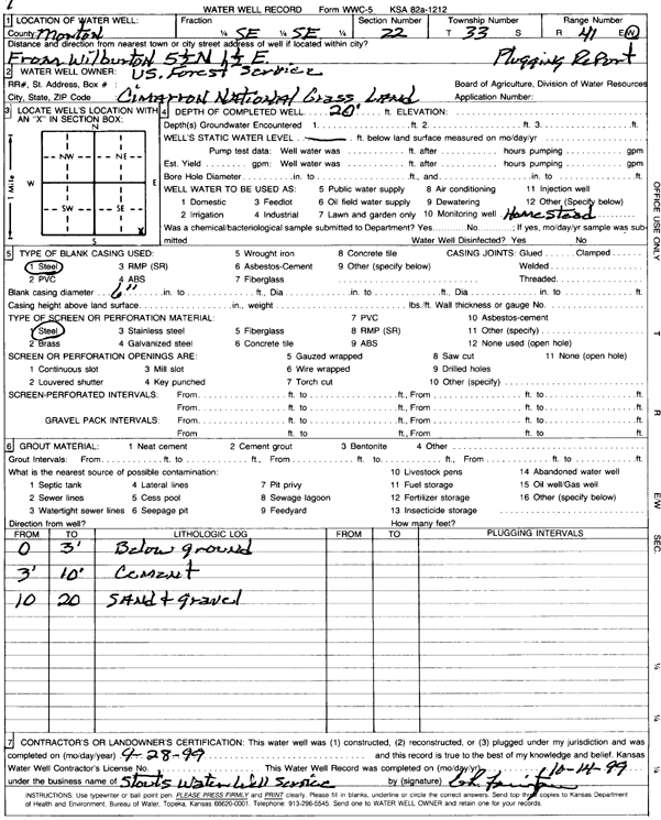
T33S, R41W, Sec. 22 SE SE |
Cimarron National Grassland | 20 ft. | Domestic | Well 7 | Plugged | 28-Sep-1999 | Scan | ||
|
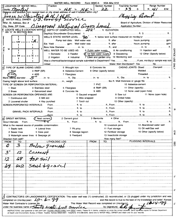
T33S, R41W, Sec. 22 NE NE |
Cimarron National Grassland | 212 ft. | 80 ft. | Oil Field Water Supply | Well 15 | Plugged | 06-Oct-1999 | Scan | |
|
T33S, R41W, Sec. 22 C NE NE |
Morton County Grazing Assoc. | 210 ft. | 85 ft. | 50 gpm. | Oil Field Water Supply | Constructed | 13-Dec-1981 | ||
|
T33S, R41W, Sec. 23 C |
Morton County Grazing Assoc. | 140 ft. | 42 ft. | 40 gpm. | Domestic | Constructed | 09-May-1990 | ||
|
T33S, R41W, Sec. 25 C SW NE |
Anadarko Petroleum Corp. | 200 ft. | 70 ft. | 45 gpm. | Oil Field Water Supply | Honour A 1 | Constructed | 17-Jun-1975 | |
|
T33S, R41W, Sec. 26 SW SE NW |
Cimarron National Grassland | 30 ft. | Domestic, Livestock | Plugged | 21-Aug-1998 | ||||
|
T33S, R41W, Sec. 27 SW SE SE |
Morton County Grazing Assoc. | 120 ft. | 60 ft. | 45 gpm. | Domestic, Livestock | Constructed | 21-Sep-1977 | ||
|
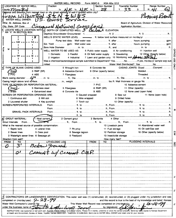
T33S, R41W, Sec. 28 NE NE |
Cimarron National Grassland | 3 ft. | Domestic | Well 9 | Plugged | 28-Sep-1999 | Scan | ||
|
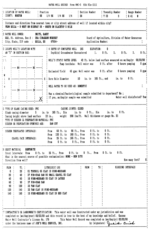
T33S, R41W, Sec. 28 SE SE SE |
Smith, Randy | 165 ft. | 42 ft. | 45 gpm. | Domestic | Constructed | 23-Feb-2000 | Scan | |
|
T33S, R41W, Sec. 31 NE SW SW |
Cimarron Recreation Area | 130 ft. | 12 ft. | 35 gpm. | Domestic | Constructed | 19-Jun-1991 | ||
|
T33S, R41W, Sec. 32 C NE |
Barnes, Bill | 244 ft. | 44 ft. | 50 gpm. | Domestic | Constructed | 28-May-2008 | ||
|
T33S, R41W, Sec. 33 SW NE NE |
Anadarko Petroleum Corp. | 245 ft. | 68 ft. | 100 gpm. | Oil Field Water Supply | USA Baker G 3 | Constructed | 29-Apr-1998 | |
|
T33S, R41W, Sec. 33 SE SE SE |
Morton County Grazing Assoc. | 190 ft. | 70 ft. | 25 gpm. | Domestic | Well 3 | Constructed | 27-Aug-1994 | |
|
T33S, R41W, Sec. 33 C SE SE |
Morton County Grazing Assoc. | 72 ft. | 68 ft. | Domestic, Livestock | Plugged | 20-Sep-1994 | |||
|
T33S, R42W, Sec. 2 C NW |
Cimarron National Grassland | 61 ft. | Domestic, Livestock | Plugged | 30-Dec-1995 | ||||
|
T33S, R42W, Sec. 2 SW SW SE |
Johnson, Marvin, Jr. | 138 ft. | 45 ft. | 25 gpm. | Domestic | Constructed | 14-Jun-1995 | ||
|
T33S, R42W, Sec. 2 NW NW SE NE |
Nelson, Seth and Jodi | 601 ft. | 132 ft. | 350 gpm. | Irrigation | Constructed | 06-Aug-2021 |
KOLAR |
|
|
T33S, R42W, Sec. 2 SW NE NE |
Nelson, Wesley | 357 ft. | 96 ft. | Irrigation | Constructed | 31-Mar-2008 | |||
|
T33S, R42W, Sec. 3 NE NE NW NW |
Parker, Chase | 240 ft. | 94 ft. | 30 gpm. | Domestic, Livestock | Constructed | 04-Sep-2018 | ||
|
T33S, R42W, Sec. 4 SW NW NW |
U.S. Forest Service | 140 ft. | 56 ft. | 40 gpm. | Domestic, Livestock | Well 12 | Constructed | 13-Jun-1978 | |
|
T33S, R42W, Sec. 5 SW SW SE |
Nelson, Seth | 600 ft. | 115 ft. | 200 gpm. | Irrigation | Constructed | 29-Feb-2012 | ||
| View page: 1 || 2 || 3 || 4 || 5 || 6 || 7 || 8 || 9 || 10 || Next > | |||||||||