Select location of well to view details.
Click on column heading to sort.
|
|
|
County: Brown Select location of well to view details. Click on column heading to sort. |
|
|
|
| View page: < Prev || 11 || 12 || 13 || 14 || 15 || 16 || 17 || 18 || 19 || 20 || Next > | |||||||||
| T-R-S | Owner | Well Depth Ascend. Desc. |
Static Water Level Ascend. Desc. |
Est. Yield Ascend. Desc. |
Well Use | Other ID | Action Taken | Completion Date Ascend. Desc. |
Scan? |
|
T2S, R17E, Sec. 28 NW NW NW |
Stop 2 Shop/JCD Investors | 30 ft. | 29.2 ft. | Monitoring well/observation/piezometer | MW 6 R | Constructed | 09-Apr-2008 | ||
|
T2S, R17E, Sec. 28 NW NW NW |
Stop 2 Shop/JCD Investors | 17.75 ft. | Monitoring well/observation/piezometer | MW 6 | Plugged | 09-Apr-2008 | |||
|
T2S, R17E, Sec. 28 NW NW SW |
40 ft. | 39.5 ft. | Monitoring well/observation/piezometer | Plugged | 01-Mar-2005 | ||||
|
T2S, R17E, Sec. 29 SE NW NW |
Ag Partners Coop | 15 ft. | 6.65 ft. | Monitoring well/observation/piezometer | MW 12 | Constructed | 23-Dec-2013 | ||
|
T2S, R17E, Sec. 29 NW NE SW |
Ag Partners Coop | 25 ft. | 8.58 ft. | Monitoring well/observation/piezometer | MW 8 | Constructed | 06-Dec-2023 |
KOLAR |
|
|
T2S, R17E, Sec. 29 SE NW SW |
Ag Partners Coop | 30 ft. | 9.43 ft. | Monitoring well/observation/piezometer | MW 1 | Constructed | 06-Dec-2023 |
KOLAR |
|
|
T2S, R17E, Sec. 29 NE NW SW |
Ag Partners Coop | 25 ft. | 9.45 ft. | Monitoring well/observation/piezometer | MW 5 | Constructed | 06-Dec-2023 |
KOLAR |
|
|
T2S, R17E, Sec. 29 NW NE SW |
Ag Partners Coop | 25 ft. | 8.46 ft. | Monitoring well/observation/piezometer | MW 7 | Constructed | 06-Dec-2023 |
KOLAR |
|
|
T2S, R17E, Sec. 29 NW NW SW |
Ag Partners Coop | 30 ft. | 6.78 ft. | Monitoring well/observation/piezometer | MW 2 | Constructed | 06-Dec-2023 |
KOLAR |
|
|
T2S, R17E, Sec. 29 NE NW SW |
Ag Partners Coop | 25 ft. | 3.74 ft. | Monitoring well/observation/piezometer | MW 4 | Constructed | 06-Dec-2023 |
KOLAR |
|
|
T2S, R17E, Sec. 29 NE NW SW |
Ag Partners Coop | 28.5 ft. | 3.57 ft. | Monitoring well/observation/piezometer | MW 3 | Constructed | 08-Jul-2025 |
KOLAR |
|
|
T2S, R17E, Sec. 29 NE NW SW |
Ag Partners Coop | 25 ft. | 8.06 ft. | Monitoring well/observation/piezometer | MW 6 | Constructed | 06-Dec-2023 |
KOLAR |
|
|
T2S, R17E, Sec. 29 SW NW NE |
Bearce, Patricia | 25.05 ft. | Monitoring well/observation/piezometer | MW 4 | Plugged | 27-Aug-2015 | |||
|
T2S, R17E, Sec. 29 SW NW NE |
Bearce, Patricia | 25.19 ft. | Monitoring well/observation/piezometer | MW 2 | Plugged | 27-Aug-2015 | |||
|
T2S, R17E, Sec. 29 SW NW NE |
Bearce, Patricia | 25 ft. | Monitoring well/observation/piezometer | MW 1 | Plugged | 27-Aug-2015 | |||
|
T2S, R17E, Sec. 29 SW NW NE |
Bearce, Patricia | 25.22 ft. | 9.51 ft. | Monitoring well/observation/piezometer | MW 6 | Constructed | 18-Mar-2014 | ||
|
T2S, R17E, Sec. 29 SW NW NE |
Bearce, Patricia | 24.06 ft. | Monitoring well/observation/piezometer | MW 5 | Plugged | 27-Aug-2015 | |||
|
T2S, R17E, Sec. 29 SW NW NE |
Bearce, Patricia | 25.05 ft. | 9.99 ft. | Monitoring well/observation/piezometer | MW 5 | Constructed | 19-Mar-2014 | ||
|
T2S, R17E, Sec. 29 SW NW NE |
Bearce, Patricia | 19.31 ft. | Monitoring well/observation/piezometer | MW 3 | Plugged | 27-Aug-2015 | |||
|
T2S, R17E, Sec. 29 SW NW NE |
Bearce, Patricia | 25.2 ft. | Monitoring well/observation/piezometer | MW 6 | Plugged | 27-Aug-2015 | |||
|
T2S, R17E, Sec. 29 SW NW NE |
Bearce, Patricia | 25.06 ft. | 10.63 ft. | Monitoring well/observation/piezometer | MW 1 | Constructed | 17-Mar-2014 | ||
|
T2S, R17E, Sec. 29 SW NW NE |
Bearce, Patricia | 25.25 ft. | 13.27 ft. | Monitoring well/observation/piezometer | MW 2 | Constructed | 18-Mar-2014 | ||
|
T2S, R17E, Sec. 29 SW NW NE |
Bearce, Patricia | 22.35 ft. | 9.89 ft. | Monitoring well/observation/piezometer | MW 3 | Constructed | 17-Mar-2014 | ||
|
T2S, R17E, Sec. 29 SW NW NE |
Bearce, Patricia | 25.1 ft. | 9.62 ft. | Monitoring well/observation/piezometer | MW 4 | Constructed | 18-Mar-2014 | ||
|
T2S, R17E, Sec. 29 NW NE SE NW |
Brown County | 48 ft. | 6.5 ft. | Domestic | Plugged | 11-Aug-2009 | |||
|
T2S, R17E, Sec. 29 NW NE SE NW |
Brown County | 50 ft. | 6.5 ft. | Domestic | Plugged | 08-Jul-2009 | |||
|
T2S, R17E, Sec. 29 SW SW SW |
Brown County | 44.5 ft. | 20 ft. | (unstated)/abandoned | Plugged | 29-Nov-1990 | |||
|
T2S, R17E, Sec. 29 SW NE NW |
Brown County Coop | 12.5 ft. | 10.58 ft. | Monitoring well/observation/piezometer | MW 3 | Constructed | 14-Jul-1994 | ||
|
T2S, R17E, Sec. 29 SW NE NW |
Brown County Coop | 12.5 ft. | 7.76 ft. | Monitoring well/observation/piezometer | MW 2 | Constructed | 14-Jul-1994 | ||
|
T2S, R17E, Sec. 29 SW NE NW |
Brown County Coop | 12.5 ft. | 6.16 ft. | Monitoring well/observation/piezometer | MW 4 | Constructed | 14-Jul-1994 | ||
|
T2S, R17E, Sec. 29 SW NE NW |
Brown County Coop | 12.5 ft. | 4.2 ft. | Monitoring well/observation/piezometer | MW 6 | Constructed | 14-Jul-1994 | ||
|
T2S, R17E, Sec. 29 SW NE NW |
Brown County Coop | 12 ft. | 2 ft. | Monitoring well/observation/piezometer | MW 9 | Constructed | 18-Nov-1996 | ||
|
T2S, R17E, Sec. 29 SW NE NW |
Brown County Coop | 18 ft. | 6.44 ft. | Monitoring well/observation/piezometer | MW 8 | Constructed | 18-Nov-1996 | ||
|
T2S, R17E, Sec. 29 SW NE NW |
Brown County Coop | 12.5 ft. | 5.22 ft. | Monitoring well/observation/piezometer | MW 1 | Constructed | 14-Jul-1994 | ||
|
T2S, R17E, Sec. 29 SW NE NW |
Brown County Coop | 12.03 ft. | Monitoring well/observation/piezometer | MW 1 | Plugged | 07-Aug-2014 | |||
|
T2S, R17E, Sec. 29 SW NE NW |
Brown County Coop | 12.43 ft. | Monitoring well/observation/piezometer | MW 2 | Plugged | 07-Aug-2014 | |||
|
T2S, R17E, Sec. 29 SW NE NW |
Brown County Coop | 12.6 ft. | Monitoring well/observation/piezometer | MW 3 | Plugged | 07-Aug-2014 | |||
|
T2S, R17E, Sec. 29 SW NE NW |
Brown County Coop | 12.44 ft. | Monitoring well/observation/piezometer | MW 4 | Plugged | 07-Aug-2014 | |||
|
T2S, R17E, Sec. 29 SW NE NW |
Brown County Coop | 11.74 ft. | Monitoring well/observation/piezometer | MW 7 | Plugged | 07-Aug-2014 | |||
|
T2S, R17E, Sec. 29 SW NE NW |
Brown County Coop | 17.7 ft. | Monitoring well/observation/piezometer | MW 8 | Plugged | 07-Aug-2014 | |||
|
T2S, R17E, Sec. 29 SW NE NW |
Brown County Coop | 12.29 ft. | Monitoring well/observation/piezometer | MW 5 | Plugged | 07-Aug-2014 | |||
|
T2S, R17E, Sec. 29 SW NE NW |
Brown County Coop | 11.32 ft. | Monitoring well/observation/piezometer | MW 9 | Plugged | 07-Aug-2014 | |||
|
T2S, R17E, Sec. 29 SW NE NW |
Brown County Coop | 14.38 ft. | Monitoring well/observation/piezometer | MW 10 | Plugged | 07-Aug-2014 | |||
|
T2S, R17E, Sec. 29 SW NE NW |
Brown County Coop | 14.77 ft. | Monitoring well/observation/piezometer | MW 11 | Plugged | 07-Aug-2014 | |||
|
T2S, R17E, Sec. 29 SW NW NW |
Brown County Coop | 15.03 ft. | Monitoring well/observation/piezometer | MW 12 | Plugged | 07-Aug-2014 | |||
|
T2S, R17E, Sec. 29 SW NE NW |
Brown County Coop | 12 ft. | 5.19 ft. | Monitoring well/observation/piezometer | MW 7 | Constructed | 18-Nov-1996 | ||
|
T2S, R17E, Sec. 29 SW NE NW |
Brown County Coop | 12.5 ft. | 4.1 ft. | Monitoring well/observation/piezometer | MW 5 | Constructed | 14-Jul-1994 | ||
|
T2S, R17E, Sec. 29 SE NW NE |
Casey's General Store | 45 ft. | 13.86 ft. | Monitoring well/observation/piezometer | MW 2 | Constructed | 26-Jul-1994 | ||
|
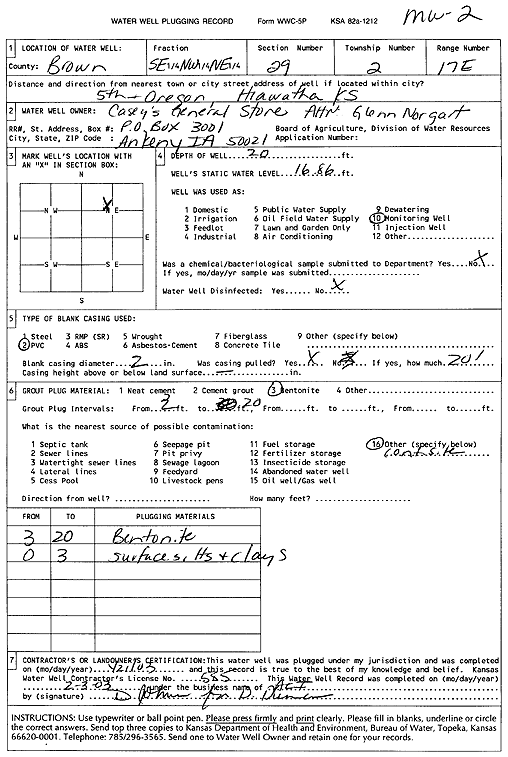
T2S, R17E, Sec. 29 SE NW NE |
Casey's General Store | 20 ft. | 16.86 ft. | Monitoring well/observation/piezometer | MW 2 | Plugged | 21-Jan-2003 | Scan | |
|
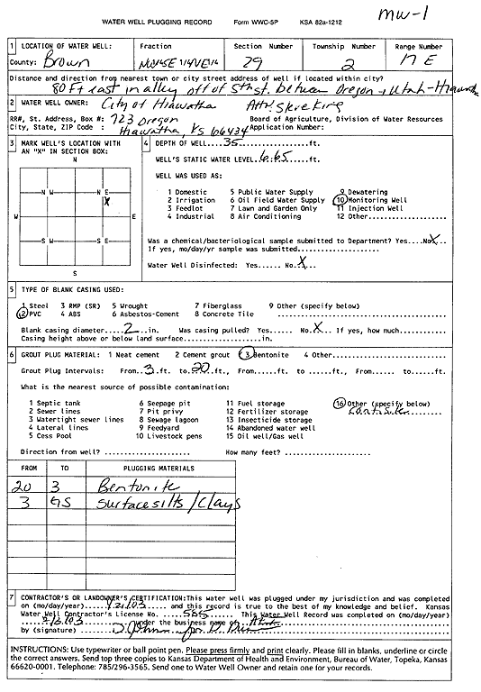
T2S, R17E, Sec. 29 NW SE NE |
City of Hiawatha | 35 ft. | 6.65 ft. | Monitoring well/observation/piezometer | MW 1 | Plugged | 21-Jan-2003 | Scan | |
| View page: < Prev || 11 || 12 || 13 || 14 || 15 || 16 || 17 || 18 || 19 || 20 || Next > | |||||||||