Select location of well to view details.
Click on column heading to sort.
|
|
|
County: Nemaha Select location of well to view details. Click on column heading to sort. |
|
|
|
| View page: 1 || 2 || 3 || 4 || 5 || 6 || 7 || 8 || 9 || 10 || Next > | |||||||||
| T-R-S | Owner | Well Depth Ascend. Desc. |
Static Water Level Ascend. Desc. |
Est. Yield Ascend. Desc. |
Well Use | Other ID | Action Taken | Completion Date Ascend. Desc. |
Scan? |
|
T2S, R13E, Sec. 36 NW SW NE |
Nemaha County Landfill | 60 ft. | 21.5 ft. | Monitoring well/observation/piezometer | Well 6 | Constructed | 09-May-1975 | ||
|
T2S, R13E, Sec. 36 NW SW NE |
Nemaha County Landfill | 80 ft. | 6 ft. | Monitoring well/observation/piezometer | Constructed | 12-Jan-1994 | |||
|
T2S, R13E, Sec. 36 C SW NE |
Nemaha County Landfill | 60 ft. | 21.5 ft. | Monitoring well/observation/piezometer | Well 5 | Constructed | 09-May-1975 | ||
|
T2S, R13E, Sec. 36 NW NW NE |
Nemaha County Landfill | 49 ft. | 9 ft. | Monitoring well/observation/piezometer | Well 1 | Constructed | 09-May-1975 | ||
|
T2S, R13E, Sec. 36 NE SW NE |
Nemaha County Landfill | 60 ft. | 18 ft. | Monitoring well/observation/piezometer | Constructed | 11-Jan-1994 | |||
|
T2S, R13E, Sec. 36 SE SW NE |
Nemaha County Landfill | 80 ft. | 12 ft. | Monitoring well/observation/piezometer | Constructed | 14-Jan-1994 | |||
|
T2S, R13E, Sec. 36 SW SW NE |
Nemaha County Landfill | 60 ft. | 16.7 ft. | Monitoring well/observation/piezometer | Well 4 | Constructed | 10-May-1975 | ||
|
T2S, R13E, Sec. 36 SE NW NE |
Nemaha County Landfill | 60 ft. | 6 ft. | Monitoring well/observation/piezometer | Well 2 | Constructed | 09-May-1975 | ||
|
T2S, R13E, Sec. 36 SW SW NE |
Nemaha County Landfill | 80 ft. | 10 ft. | Monitoring well/observation/piezometer | Constructed | 20-Jan-1994 | |||
|
T2S, R13E, Sec. 36 W2 NE |
Nemaha County Landfill | 60 ft. | (unstated)/abandoned | Well 7 | Plugged | 03-Jun-1975 | |||
|
T2S, R13E, Sec. 36 S2 NW NE |
Nemaha County Landfill | 60 ft. | 7.6 ft. | Monitoring well/observation/piezometer | Well 3 | Constructed | 09-May-1975 | ||
|
T2S, R13E, Sec. 36 NE NW NE |
Nemaha County Sanitary Landfill | 60 ft. | Monitoring well/observation/piezometer | 9f | Plugged | 03-Jun-1975 | |||
|
T2S, R13E, Sec. 36 NE NW NE |
Nemaha County Sanitary Landfill | 60 ft. | 16.66 ft. | Monitoring well/observation/piezometer | 9g | Constructed | 03-Jun-1975 | ||
|
T2S, R13E, Sec. 36 NE NW NE |
Nemaha County Sanitary Landfill | 60 ft. | 7.583 ft. | Monitoring well/observation/piezometer | 9c | Constructed | 03-Jun-1975 | ||
|
T2S, R13E, Sec. 36 NE NW NE |
Nemaha County Sanitary Landfill | 60 ft. | 6 ft. | Monitoring well/observation/piezometer | 9b | Constructed | 03-Jun-1975 | ||
|
T2S, R13E, Sec. 36 NE NW NE |
Nemaha County Sanitary Landfill | 60 ft. | 21.33 ft. | Monitoring well/observation/piezometer | 9e | Constructed | 03-Jun-1975 | ||
|
T2S, R13E, Sec. 36 NE NW NE |
Nemaha County Sanitary Landfill | 49 ft. | 9.25 ft. | Monitoring well/observation/piezometer | 9a | Constructed | 03-Jun-1975 | ||
|
T2S, R13E, Sec. 36 NE NW NE |
Nemaha County Sanitary Landfill | 60 ft. | 21.5 ft. | Monitoring well/observation/piezometer | 9d | Constructed | 03-Jun-1975 | ||
|
T2S, R14E, Sec. 1 NW SE SW |
Agees Service Inc. | 137 ft. | 114 ft. | 20 gpm. | Industrial | Constructed | 14-Jan-1989 | ||
|
T2S, R14E, Sec. 1 NW NW NE |
Albany Properties | 100 ft. | 47 ft. | 20 gpm. | Domestic, Lawn and Garden | Constructed | 06-Nov-2006 | ||
|
T2S, R14E, Sec. 1 NW NW NE |
Albany Properties | 100 ft. | 62 ft. | 40 gpm. | Domestic, Lawn and Garden | Constructed | 03-Nov-2006 | ||
|
T2S, R14E, Sec. 1 SW NW NW |
Allison, Bob | 120 ft. | 98 ft. | 15 gpm. | Domestic, Lawn and Garden | Constructed | 11-Aug-1981 | ||
|
T2S, R14E, Sec. 1 NW SE SE |
Baker, Gerald | 160 ft. | 110 ft. | 10 gpm. | Domestic | Constructed | 23-Aug-1989 | ||
|
T2S, R14E, Sec. 1 NE SE NW |
Bockerstette, Gene | 120 ft. | 78 ft. | 20 gpm. | Domestic, Lawn and Garden | Constructed | 23-May-1992 | ||
|
T2S, R14E, Sec. 1 NE SW SW |
Bowlinger, Fred | 178 ft. | 106 ft. | 8 gpm. | Domestic | Constructed | 03-Aug-1983 | ||
|
T2S, R14E, Sec. 1 SE SW NW |
Busch, Tom and Ann | 132 ft. | 97.42 ft. | 25 gpm. | Domestic, Lawn and Garden | Constructed | 01-Aug-2013 | ||
|
T2S, R14E, Sec. 1 NE SE SE |
Casey's General Store | 25 ft. | 5.41 ft. | Monitoring well/observation/piezometer | MW 1 | Constructed | 23-Jul-1997 | ||
|
T2S, R14E, Sec. 1 NE SE SE |
Casey's General Store | 25 ft. | 8.13 ft. | Monitoring well/observation/piezometer | Constructed | 24-Jul-1997 | |||
|
T2S, R14E, Sec. 1 NW SW SW |
Casey's General Store | 25 ft. | 5.42 ft. | Monitoring well/observation/piezometer | MW 10 | Constructed | 24-Jul-1997 | ||
|
T2S, R14E, Sec. 1 SE NE SE |
Casey's General Store | 25 ft. | 10.47 ft. | Monitoring well/observation/piezometer | MW 8 R | Constructed | 13-Aug-2014 | ||
|
T2S, R14E, Sec. 1 NE SE SE |
Casey's General Store | 25 ft. | 6.96 ft. | Monitoring well/observation/piezometer | MW 7 | Constructed | 24-Jul-1997 | ||
|
T2S, R14E, Sec. 1 SE NE SE |
Casey's General Store | 20 ft. | 20.06 ft. | Monitoring well/observation/piezometer | MW 2 R | Constructed | 13-Aug-2014 | ||
|
T2S, R14E, Sec. 1 NE NE SE SE |
Casey's General Store | 20 ft. | 3.15 ft. | Monitoring well/observation/piezometer | MW 18 | Constructed | 17-Dec-2019 |
KOLAR |
|
|
T2S, R14E, Sec. 1 NW SW SW |
Casey's General Store | 25 ft. | 5.93 ft. | Monitoring well/observation/piezometer | MW 4 | Constructed | 23-Jul-1997 | ||
|
T2S, R14E, Sec. 1 NW SW SW |
Casey's General Store | 25 ft. | 6.69 ft. | Monitoring well/observation/piezometer | MW 5 | Constructed | 23-Jul-1997 | ||
|
T2S, R14E, Sec. 1 NE SE SE |
Casey's General Store | 25 ft. | 6.66 ft. | Monitoring well/observation/piezometer | MW 9 | Constructed | 24-Jul-1997 | ||
|
T2S, R14E, Sec. 1 NE SE SE |
Casey's General Store | 20 ft. | 7.08 ft. | Monitoring well/observation/piezometer | MW 3 | Constructed | 23-Jul-1997 | ||
|
T2S, R14E, Sec. 1 NW SW SW |
Casey's General Store | 25 ft. | 5.39 ft. | Monitoring well/observation/piezometer | MW 6 | Constructed | 23-Jul-1997 | ||
|
T2S, R14E, Sec. 1 NE NE SE SE |
Casey's General Store | 20 ft. | 4.05 ft. | Monitoring well/observation/piezometer | MW 15 | Constructed | 17-Dec-2019 |
KOLAR |
|
|
T2S, R14E, Sec. 1 NE SE SE |
Casey's General Store | 20 ft. | 5.47 ft. | Monitoring well/observation/piezometer | MW 2 | Constructed | 23-Jul-1997 | ||
|
T2S, R14E, Sec. 1 SE NE SE |
Casey's General Store | 25 ft. | 6.17 ft. | Monitoring well/observation/piezometer | MW 8 | Constructed | 24-Jul-1997 | ||
|
T2S, R14E, Sec. 1 NE NE SE SE |
Casey's Retail Co. | 20 ft. | 16.25 ft. | Monitoring well/observation/piezometer | MW 19 | Constructed | 04-Aug-2022 | ||
|
T2S, R14E, Sec. 1 NE NE SE SE |
Casey's Retail Co. | 20 ft. | 16.25 ft. | Monitoring well/observation/piezometer | MW 15 R | Constructed | 04-Aug-2022 | ||
|
T2S, R14E, Sec. 1 NE NE SE SE |
Casey's Retail Co. | 20 ft. | 16.25 ft. | Monitoring well/observation/piezometer | MW 1 R | Constructed | 04-Aug-2022 | ||
|
T2S, R14E, Sec. 1 NE NE SE SE |
Casey's Retail Co. | 20 ft. | 16.25 ft. | Monitoring well/observation/piezometer | MW 21 | Constructed | 04-Aug-2022 | ||
|
T2S, R14E, Sec. 1 NE NE SE SE |
Casey's Retail Co. | 20 ft. | 12.85 ft. | Monitoring well/observation/piezometer | MW 20 | Constructed | 02-Aug-2022 | ||
|
T2S, R14E, Sec. 1 SE NW SW |
City of Sabetha | 13.05 ft. | 3.17 ft. | Monitoring well/observation/piezometer | MW 11 | Plugged | 06-Jan-2009 | ||
|
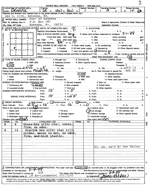
T2S, R14E, Sec. 1 SE NW SW |
City of Sabetha | 13 ft. | 0 ft. | Monitoring well/observation/piezometer | MW 7 | Constructed | 09-Feb-1999 | Scan | |
|
T2S, R14E, Sec. 1 NE SE NE |
City of Sabetha | 100 ft. | 58 ft. | 60 gpm. | Public Water Supply | Constructed | 26-Jan-1989 | ||
|
T2S, R14E, Sec. 1 SE NW SW |
City of Sabetha | 14.85 ft. | 2.58 ft. | Monitoring well/observation/piezometer | MW 2 | Plugged | 06-Jan-2009 | ||
| View page: 1 || 2 || 3 || 4 || 5 || 6 || 7 || 8 || 9 || 10 || Next > | |||||||||